Approximate Location Map
Large Map »
This site is entirely user-supported. See how you can help.
If Google Street View is available, the image is from the best available vantage point looking, if possible, towards the location of the monument. Where it is not available, the satellite view is shown instead.
Latitude: 55.9096 / 55°54'34"N
Longitude: -3.0676 / 3°4'3"W
OS Eastings: 333357
OS Northings: 669017
OS Grid: NT333690
Mapcode National: GBR 7003.ND
Mapcode Global: WH6SV.VQDG
Entry Name: Newton Church,church,enclosures and field system
Scheduled Date: 9 November 1992
Source: Historic Environment Scotland
Source ID: SM5441
Schedule Class: Cultural
Category: Ecclesiastical: church; Secular: enclosure
Location: Newton
County: Midlothian
Electoral Ward: Dalkeith
Traditional County: Midlothian
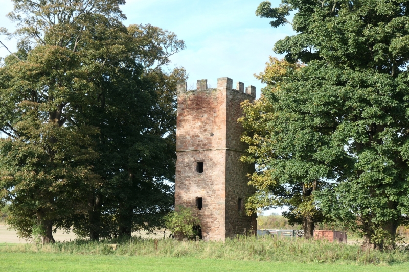
The monument consists of the remains of the 17th century tower of Old Newton Kirk also called St Mary's, its surrounding graveyard which is situated within a group of three contiguous sub rectangular
enclosures of medieval date, and an adjacent rig and furrow field system. The enclosures and field system are only visible in aerial photographs.
The roofless church tower (height c.10.5m) is built of rough cast
rubble with ashlar dressings. It has had five storeys with a
crenellated parapet. The upper storeys above the horizontal string course set at third floor level appear to have been rebuilt shortly after 1915. The tower is oblong on plan, measuring 5.1m N-S by 4.8m
E-W. The rest of the gabled church is no longer extant. It appears to have been constructed at a subsequent date to the tower and would
have been built against its N wall. The entrance from the N wall of
the tower to the body of the church has been blocked up, other
blocked entrances are in the N and W walls on the first floor. In the
S wall of the tower is a semi-circular headed doorway and a small
window in the E wall. The wooded burial ground has been fenced off.
The rectangular area measures 28m NW by 18.5m NE. In it are three eighteenth century table tombs. The church and burial ground occupy
the NE end of a large sub rectangular enclosure which is contiguous
with two smaller enclosures of similar shape. In the NE enclosure
there are a group of post holes which indicate the position of at
least one rectangular building. The area of these enclosures which appear as crop marks is 140m NW by 80m NE. To the NW of the
enclosures is an area of rig and furrow which is probably of contemporary date. This feature has been truncated by the Edinburgh
City bypass.
The area to be scheduled is an irregular pentagon, it includes the church tower, surrounding enclosures and a sample of the associated field system. The N boundary is defined by the line of the overhead electricity cable on the S side of the Edinburgh City bypass, the S boundary is defined by the wall of Dalkeith Park. The area measures a maximum of 280m E-W by 160m N-S, as marked in red on the accompanying map.
Source: Historic Environment Scotland
Bibliography
No Bibliography entries for this designation
Source: Historic Environment Scotland
Other nearby scheduled monuments