Approximate Location Map
Large Map »
This site is entirely user-supported. See how you can help.
If Google Street View is available, the image is from the best available vantage point looking, if possible, towards the location of the monument. Where it is not available, the satellite view is shown instead.
Latitude: 50.9726 / 50°58'21"N
Longitude: 0.8914 / 0°53'28"E
OS Eastings: 603089.626835
OS Northings: 123221.873232
OS Grid: TR030232
Mapcode National: GBR T05.XX2
Mapcode Global: FRA D6RJ.WLJ
Entry Name: Abandoned Medieval Church and Graveyard, Midley
Scheduled Date: 15 December 1989
Source: Historic England
Source ID: 1012338
English Heritage Legacy ID: 12705
County: Kent
Civil Parish: Lydd
Traditional County: Kent
Lieutenancy Area (Ceremonial County): Kent
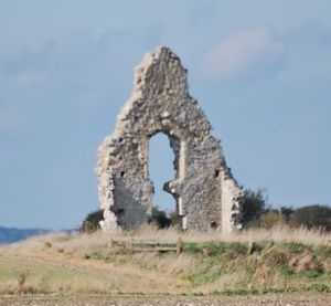
The remains of the church at Midley are situated on a slight rise between Lydd
and Old Romney. Only the west gable and fragments of the north and south
walls remain upstanding, rising to a maximum height of 8 metres. The walls
are made of unusual buff-coloured bricks. Although deteriorated, the window
openings and doorway survive in sufficient detail to suggest a date in the
later 15th century for the building of this part of the church. The complete
ground-plan of this structure is assumed to have survived unaltered since the
decay of the church since before 1573.
Midley church (formerly "Midelea"), however, is mentioned in Domesday and at
least one phase of church is presumed to underlie the present ruined building,
signified by the distinct mound some 20m by 15m on which the upstanding
remains are situated. The underlying church is likely to date from the
12th/13th century, and is contemporary with a neighbouring deserted medieval
village (now destroyed). Around the ruins, especially on the west side,
fragments of human bone visible on the surface indicate the location of a
graveyard belonging to the church.
The upstanding walls are listed grade II (Vol. 437, 9/99).
MAP EXTRACT
The site of the monument is shown on the attached map extract.
Source: Historic England
The remains of the later 15th century church at Midley survive only partially
but to an impressive height of 8 metres at the west end. The upstanding walls
and ground-plan of this church are of great architectural and historical
importance because the church demonstrates a very rare and early use of brick
for building in the region. The site is lent additional importance by the
high archaeological potential of the land around the surviving remains, both
for the earlier church buildings considered to survive as foundations below
the present structure (Domesday Book refers to a church at Midelea) and for
its adjoining graveyard in which bone is well preserved. From these
archaeological contexts can be expected evidence of the disastrous floods in
ca. 1287 (eg. changes in the death rate, evidence of depopulation, flood
damage to the church itself). These were the same floods in which Old
Winchelsea perished and which precipitated dramatic changes in the development
of the region for which little evidence survives, relevant contexts having
been either submerged by the sea or altered in more recent times.
Source: Historic England
Other
Listed buildings Vol 437, 9/99, (1959)
R.A.F. 4008 UK/1752:21, R.A.F. 4008 UK/1752:21, (1946)
Tatton-Brown, T, Midley Parish Church, 1988, Unpublished note
Source: Historic England
Other nearby scheduled monuments