Approximate Location Map
Large Map »
This site is entirely user-supported. See how you can help.
If Google Street View is available, the image is from the best available vantage point looking, if possible, towards the location of the monument. Where it is not available, the satellite view is shown instead.
Latitude: 54.0829 / 54°4'58"N
Longitude: -0.8767 / 0°52'35"W
OS Eastings: 473585.454392
OS Northings: 465803.744308
OS Grid: SE735658
Mapcode National: GBR QPB7.04
Mapcode Global: WHFBM.HMRV
Entry Name: Kirkham Priory Augustinian monastery: monastic precinct, three fishponds, and precinct boundary
Scheduled Date: 9 October 1981
Last Amended: 24 April 1996
Source: Historic England
Source ID: 1014024
English Heritage Legacy ID: 13269
County: North Yorkshire
Civil Parish: Westow
Traditional County: Yorkshire
Lieutenancy Area (Ceremonial County): North Yorkshire
Kirkham Priory is situated on the north east bank of the River Derwent between
York and Malton. The monument comprises two separate areas, the first
containing the standing remains and precinct of the Augustinian priory of the
Holy Trinity and the second a line of three fishponds.
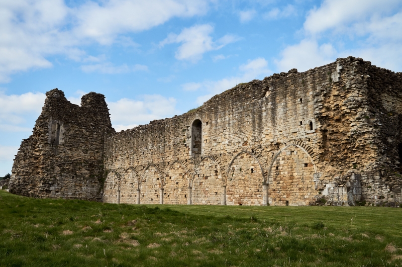
The standing remains include the 12th and 13th century ruins of the priory
church whose east front is still partly upstanding and the nave of which forms
the north range of the cloister. The late 13th century chapter house and
dorter (sleeping quarters) form the east range while the frater (refectory) is
located to the south. Additional domestic buildings make up the west side of
the cloister with a separate guest house and kitchen lying to the south of
these. To the south of the east range lay a complex of late 13th and 14th
century buildings comprising the kitchen, prior's lodging, infirmary and
reredorter (latrine) with a drain running underneath. A separate gatehouse
dating to the late 13th century lies to the north west, and the stump of a
square-section 14th century cross, supported on a stepped plinth and with a
limestone base carved with pairs of quatrefoils, stands outside. To the north
and east of the upstanding remains, traces of a right-angled bank make up the
visible remains of the precinct boundary. This is at its most substantial on
the south east side where it runs downslope, north east to south west, and
measures c.5m wide and c.1m high. To the north west of the precinct, alongside
the river, is a line of three associated fishponds. Kirkham Priory is a Grade
I Listed Building and the cross-stump is Grade II Listed.
Extensive documentation tells us that Kirkham Priory was founded by Walter
Espec, Lord of Helmsley, in the 1120s. Soon after its foundation it survived a
move to transfer it to the Cistercian order and flourished in the 13th century
under the patronage of the de Roos family, Espec's successors at Helmsley. A
major rebuilding programme began at this time but was never completed as, by
the end of the 13th century, the priory was heavily in debt. It continued to
support a prior and 16 canons, however, almost up to its suppression in 1539.
After this date it gradually fell into ruin until being placed in State care
in 1927.
Excluded from the scheduling are all English Heritage fittings such as the
ticket office, benches, signs and grilles, and also the modern gate and the
surfaces of paths and driveway. Also excluded are sheds inside the gate tower
and against the south east boundary, a stone building lying half inside the
area of the scheduling on the south east side, the water-tank next to it, two
electricity boxes and all modern boundary walls and fencing. The ground
beneath all these features, however, is included.
MAP EXTRACT
The site of the monument is shown on the attached map extract.
Source: Historic England
From the time of St Augustine's mission to refound Christianity in AD 597 to
the reign of Henry VIII, monasteries formed an important facet of both
religious and secular life in the British Isles. Monasteries were built to
house communities of monks, canons (priests), and sometimes lay-brothers,
living a common life of religious observance under some form of systematic
discipline. It is estimated from documentary evidence that over 700
monasteries were founded in England. These ranged in size from major
communities with several hundred members to tiny establishments with a handful
of brethren. They belonged to a wide variety of different religious orders,
each with its own philosophy. As a result, they vary considerably in the
detail of their appearance and layout, although all possess the basic elements
of church, domestic accommodation for the community, and work buildings.
Monasteries were inextricably woven into the fabric of medieval society,
acting not only as centres of worship, learning, and charity, but also,
because of the vast landholdings of some orders, of immense wealth and
political influence. They were established in all parts of England, some in
towns and others in the remotest of areas. Many monasteries acted as the
centre of a wide network including parish churches, almshouses, hospitals,
farming estates and tenant villages.
Some 225 of these religious houses belonged to the Order of Saint Augustine.
The Augustinians were not monks in the strict sense, but rather communities of
canons - or priests - living under the rule of Saint Augustine. From the
twelfth century onwards, they undertook much valuable work in the parishes,
running almshouses, schools and hospitals as well as maintaining and preaching
in parish churches. It was from the churches that they derived much of their
revenue.
Kirkham Priory is particularly important for its wide range of surviving
features, including both upstanding remains and monastic earthworks, which
together provide important evidence of the economy and way of life peculiar to
Augustinian monasticism. Fish from the ponds provided a significant
contribution to the monastic economy. The location of these ponds in low-
lying ground frequently waterlogged and flooded means that organic and
palaeo-environmental remains will have survived.
Source: Historic England
Books and journals
'The Times' in 10/10/1927, (1927)
Other
DOE Historic Plans room, Mitchinson, H, (DOE Historic Plans room), (1932)
Sir Charles Peers, Kirkham Priory, 1988, Official HBMC Handbook
Williams, R A W, (Archive with Williams R A W), (1978)
YAS archives MSS 397 and 399, Hope, W H St John, (YAS archives MSS 397 and 399), (1886)
Source: Historic England
Other nearby scheduled monuments