Approximate Location Map
Large Map »
This site is entirely user-supported. See how you can help.
If Google Street View is available, the image is from the best available vantage point looking, if possible, towards the location of the monument. Where it is not available, the satellite view is shown instead.
Latitude: 53.2272 / 53°13'38"N
Longitude: -2.9761 / 2°58'33"W
OS Eastings: 334935.338548
OS Northings: 370464.324676
OS Grid: SJ349704
Mapcode National: GBR 76.0PL4
Mapcode Global: WH886.842S
Entry Name: Shotwick Castle motte and bailey and late medieval garden remains
Scheduled Date: 9 October 1981
Last Amended: 16 April 1999
Source: Historic England
Source ID: 1016616
English Heritage Legacy ID: 13452
County: Flintshire (Sir y Fflint)
Community: Sealand
Traditional County: Cheshire
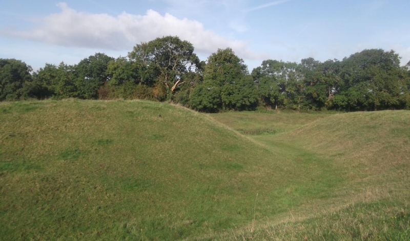
The monument at Shotwick includes a medieval motte and bailey castle on the
crest of a steep escarpment above the east bank of the former course of the
River Dee. Its defensive position is enhanced by two steep sided watercourses
flanking it on the north and south sides.
The motte itself is a small mound, hexagonal in plan and 40m by 20m at the
top. From limited excavation in the last century there appears to be the
foundations of the stone keep surviving to a depth of 2.3m under the turf. The
motte ditch surrounds the motte and is about 25m wide and 3m deep. This would
have been flooded at high tide. To the south east is a small bailey 38m wide
at the top, which reveals that it was remodelled as a part of a formal garden
scheme after its function as a defensive work had ceased.
The castle was built by Hugh Lupus, Earl of Chester, during the 11th century.
Under various owners the castle formed part of the defence of the borders with
the Welsh until 1281 when peace was finally made with the rulers of Wales. In
1327 the manor was emparked as a royal game park for the recreation of Edward
III. The manor was occupied under a series of owners acting as magistrates for
the Crown until the estate was aquired by the Wilbraham family in 1627. At
this time the castle appears to have been in ruins.
At some date within the late medieval period the north western part of the
site was formed into a series of water garden features and the bailey was
sculpted into a formal garden with terraces and parterres. The moat may have
been widened at the same time to make a further water feature for this garden
scheme. It was this western side of the moat which used to be regarded as a
quay and harbour for access to the castle from the estuary of the River Dee.
Further survey work by the Royal Commission on the Historical Monuments of
England has confirmed that the surroundings of the castle are indeed a garden.
A wide ditch cuts off the castle from its surrounding landscape on the eastern
side. This is 35m wide and 2.5m deep. The stream valley on the north west of
the site was considerably altered in the medieval period to form a water
feature, including three pools with walkways created over a series of dams and
on a spinal bank separating the water features from the moat along the north
western edge of the site. Ridge and furrow cultivation can be traced over all
of the monument, including the bottom of the moat. This has obscured much of
the detail of the earthworks.
Post and wire fences which surround the monument are excluded from the
scheduling, although the ground beneath is included.
MAP EXTRACT
The site of the monument is shown on the attached map extract.
Source: Historic England
Motte and bailey castles are medieval fortifications introduced into Britain
by the Normans. They comprised a large conical mound of earth or rubble, the
motte, surmounted by a palisade and a stone or timber tower. In a majority of
examples an embanked enclosure containing additional buildings, the bailey,
adjoined the motte. Motte castles and motte-and-bailey castles acted as
garrison forts during offensive military operations, as strongholds, and, in
many cases, as aristocratic residences and as centres of local or royal
administration. Built in towns, villages and open countryside, motte and
bailey castles generally occupied strategic positions dominating their
immediate locality and, as a result, are the most visually impressive
monuments of the early post-Conquest period surviving in the modern landscape.
Over 600 motte castles or motte-and-bailey castles are recorded nationally,
with examples known from most regions. As one of a restricted range of
recognised early post-Conquest monuments, they are particularly important for
the study of Norman Britain and the development of the feudal system. Although
many were occupied for only a short period of time, motte castles continued to
be built and occupied from the 11th to the 13th centuries, after which they
were superseded by other types of castle.
The motte and bailey castle at Shotwick together with the later medieval
garden remains survive well despite later ridge and furrow cultivation. The
earthworks are well defined and the limited excavation of the site has
demonstrated the survival of important remains of the stone foundations and
other features of the construction. The monument forms part of the post-
Conquest Anglo-Norman defence of the Welsh border and is one of the important
series of motte and bailey castles along the line.
The late medieval garden remains are of particular importance, being one
example among only a handful of similar surviving sites in England.
Source: Historic England
Books and journals
Stewart-Brown, R, 'Trans. Lancs. and Ches. Hist. Soc.' in Trans. Lancs. and Ches. Hist. Soc., , Vol. 28, (1912)
Other
In Chester City Records Office, Broster, P., Letter in the Earwaker Collection. CR/3/2/133, (1810)
Leach, P.E., MPP Single Monument Class Descriptions - Motte & Bailey Castles, (1988)
MS 2073, Harl,
Record No. 2025/1/1, Shotwick Castle, (1989)
Turner, R.C., To SMR Record No. 2025/1/1, (1987)
Source: Historic England
Other nearby scheduled monuments