Approximate Location Map
Large Map »
This site is entirely user-supported. See how you can help.
If Google Street View is available, the image is from the best available vantage point looking, if possible, towards the location of the monument. Where it is not available, the satellite view is shown instead.
Latitude: 53.2479 / 53°14'52"N
Longitude: -2.414 / 2°24'50"W
OS Eastings: 372473.649619
OS Northings: 372397.914839
OS Grid: SJ724723
Mapcode National: GBR CZLW.5F
Mapcode Global: WH99D.WMNG
Entry Name: Hulme Hall moated site
Scheduled Date: 2 January 1992
Source: Historic England
Source ID: 1012356
English Heritage Legacy ID: 13491
County: Cheshire West and Chester
Civil Parish: Allostock
Traditional County: Cheshire
Lieutenancy Area (Ceremonial County): Cheshire
Church of England Parish: Lower or Nether Peover St Oswald
Church of England Diocese: Chester
The monument is the moated site of Hulme Hall. It includes an island
measuring c.60m x 54m upon which stands Hulme Hall. Surrounding the island is
a waterlogged moat c.10-30m wide x 1.5m deep that has a 10m square projection
at the southern corner. Access to the island is via a causeway on the
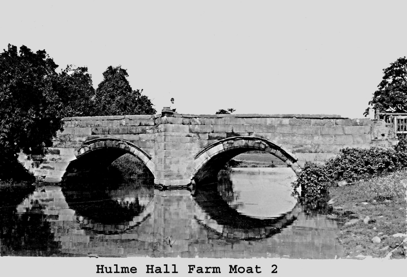
southeast arm and a bridge of 15th century origin across the northeast arm.
Hulme Hall has a long history of occupation commencing as the seat of the
Grosvenor family and passing to the Sharkleys during the 15th century. The
present hall has 15th century origins with 17th and 19th century alterations
and additions. Limited excavation on the island revealed well preserved
foundations to a depth of c.1m. Various parts of the ancient hall and their
uses are named in documentary sources of 1429.
Hulme Hall and the bridge are both Listed Buildings Grade II*.
Hulme Hall and its service pipes, the bridge, access drives, all fences,
hedges and telegraph poles, and a small structure associated with drainage in
the southerly projection of the moat are excluded from the scheduling but the
ground beneath all these features is included.
MAP EXTRACT
The site of the monument is shown on the attached map extract.
It includes a 2 metre boundary around the archaeological features,
considered to be essential for the monument's support and preservation.
Source: Historic England
Around 6,000 moated sites are known in England. They consist of wide ditches,
often or seasonally water-filled, partly or completely enclosing one or more
islands of dry ground on which stood domestic or religious buildings. In some
cases the islands were used for horticulture. The majority of moated sites
served as prestigious aristocratic and seigneurial residences with the
provision of a moat intended as a status symbol rather than a practical
military defence. The peak period during which moated sites were built was
between about 1250 and 1350 and by far the greatest concentration lies in
central and eastern parts of England. However, moated sites were built
throughout the medieval period, are widely scattered throughout England and
exhibit a high level of diversity in their forms and sizes. They form a
significant class of medieval monument and are important for the understanding
of the distribution of wealth and status in the countryside. Many examples
provide conditions favourable to the survival of organic remains.
The monument is a well preserved example of a medieval moated site. It has a
long and well documented history of occupation and limited excavation on the
island has revealed substantial evidence of structures. Further evidence of
the medieval buildings which originally occupied the site will exist beneath
the present hall and upon the remainder of the island. Additionally the
waterlogged moat will preserve organic material.
Source: Historic England
Books and journals
Ormerod, G, 'History of Cheshire' in History of Cheshire, , Vol. 3, (1882)
Wilson, D, 'CAB' in , , Vol. 6, (1978)
Other
Darvill, T., MPP Single Monument Class Description - Moats, (1988)
DOE, List of Buildings of Historic & Architectural Interest,
Scott, Mr. A. (Site occupier), To Robinson, K.D. MPPFW, (1991)
Source: Historic England
Other nearby scheduled monuments