Approximate Location Map
Large Map »
This site is entirely user-supported. See how you can help.
If Google Street View is available, the image is from the best available vantage point looking, if possible, towards the location of the monument. Where it is not available, the satellite view is shown instead.
Latitude: 52.7463 / 52°44'46"N
Longitude: -1.4664 / 1°27'58"W
OS Eastings: 436119.055892
OS Northings: 316651.091218
OS Grid: SK361166
Mapcode National: GBR 6H0.VF4
Mapcode Global: WHDHS.F7YG
Entry Name: Ashby Castle and associated formal garden
Scheduled Date: 10 April 1915
Last Amended: 13 November 1995
Source: Historic England
Source ID: 1013324
English Heritage Legacy ID: 17121
County: Leicestershire
Civil Parish: Ashby-de-la-Zouch
Built-Up Area: Ashby-de-la-Zouch
Traditional County: Leicestershire
Lieutenancy Area (Ceremonial County): Leicestershire
Church of England Parish: Ashby-de-la-Zouch St Helen
Church of England Diocese: Leicester
The monument is situated on the eastern outskirts of Ashby-de-la-Zouch and
includes the standing, earthwork and buried remains of Ashby Castle, a
fortified dwelling house, and the earthwork remains of an associated formal
garden known as The Wilderness. The core of Ashby Castle, that is the
standing ruins (which are Listed Grade I) and the garden remains, are in the
care of the Secretary of State.
The manor of Ashby was granted by William I to Hugh de Grantmesnil and
subsequently passed by marriage to the Zouch family towards the end of the
12th century. The site is primarily a 12th century house which was redesigned
and rebuilt over a period of several centuries. Following the Wars of the
Roses in the 15th century, Edward IV granted Ashby to his Lord Chamberlain,
Lord Hastings who, between 1464 and 1483, undertook an extensive building
programme at Ashby, whilst retaining many of the site's existing structures.
Although Lord Hastings was beheaded in 1483, Ashby Castle remained in the
ownership of the Hastings family until the mid 17th century. During the Civil
War it was besieged and surrendered to the Parliamentarians in 1646. Several
principal buildings were slighted, rendering them untenable, and the family
abandoned Ashby as a residence in favour of their seat at Donnington Park.
Illustrations of the site, however, indicate that several buildings remained
habitable throughout the 18th century but these are thought to have been
superseded in 1724 by the construction of Ashby Place in the northern part of
the site.
The buildings of the early Norman house are thought originally to have been
timber structures which were replaced after 1150 by ones built of stone. The
standing remains of the 12th century hall and the solar are situated in the
central part of the site and clearly formed the focal point of the original
house. In its earliest arrangement, the hall is thought to have been of two
storeys although the building has undergone several periods of rebuilding
since its construction. Blocked openings in the west wall of the hall provided
access into the original solar situated to the west. In c.1350 the hall was
redesigned as a single storey building and stone arcades were constructed to
support the roof. At the same time the arrangement of hall and solar was
reversed; a new solar was erected at the eastern end of the hall while the
existing solar to the west was adapted to serve as buttery and pantry. To the
west of the hall are the standing remains of a kitchen building. Documentary
evidence indicates that there was a kitchen here in 1347 but the standing
remains suggest that the present structure was erected between 1350 and 1400.
The kitchen is connected to the buttery and pantry by means of a passage.
The plan and extent of the early site is now unclear mostly due to the
extensive building programme which occurred at the site during the 15th
century and also due to the construction of buildings in more recent times,
particularly in the northern part of the site. However, sections of medieval
masonry and brickwork within the southern wall of St Helen's churchyard
indicate that this wall formed the northern boundary to the site and this wall
is, therefore, included in the scheduling. In the north western part of the
site a break in slope which is now overlaid by a modern wall is thought to
define the western boundary to the site. Approximately 42m to the north east
of this wall are the remains of a further length of walling which projects
northwards from the northern end of the kitchen building and, together with
the northern and eastern boundary walls, formed a courtyard area immediately
to the north of the hall and its adjacent buildings. The courtyard is now
partly occupied by the buildings of Manor House Preparatory School, the main
building of which is Listed Grade II and is excluded from the scheduling.
There is no surface evidence of the various buildings, namely domestic
quarters, stabling and storage buildings, which were originally situated here
but their foundations will survive beneath the ground surface. Access into the
site is thought to have been from the north and the remains of the gateway
will survive as a buried feature in the northern part of the courtyard. A
further courtyard occupied the area to the south of the hall. It was bounded
to the west by a wall which projects southwards from the southern wall of the
kitchen building and is thought to date from the late 14th century. There is
no surface evidence for the southern and eastern boundaries to this courtyard
but these will survive as buried features.
During the late 15th century the dwelling house at Ashby was granted to Lord
Hastings. His ambitions evidently included a desire to build on a scale worthy
of his position and in 1474 he obtained a licence to erect a fortified house
at Ashby. Several new buildings were constructed at the site during this
period, including a large tower house, known as the Hastings Tower, a chapel
and a small courtyard of domestic buildings. The chapel is thought to be the
earliest of the extensive additions which took place at the site between 1464
and 1483. It is situated to the south east of the solar building abutting its
south eastern corner. An engraving of 1730 shows that the chapel had a
low-pitched roof with large battlements. The entrance into the chapel, through
the west wall, has similar architectural details to those visible in the
Hastings Tower. Various holes within the fabric of the internal walls suggest
original wooden panelling and seating and the joist holes for a first floor
gallery are visible within the west wall.
Immediately to the south east of the chapel are the standing remains of a
range of two storey buildings, traditionally known as the Priest's Rooms,
although they are thought to have served as guest rooms. Each suite of rooms
has a fireplace and a garderobe, and a staircase contructed within the north
wall originally provided access to the upper floor. The scar of a roof-line is
visible at the western end of the chapel's southern wall indicating that a
further building range projected southwards from here; the remains of which
will survive as buried features. This former building range and that to the
east originally formed a small courtyard in this part of the site. In the
southern part of the courtyard are the foundations of further buildings which
were demolished during Hastings' building programme. These buildings are
partly overlain by a wall which forms the southern boundary to the courtyard
and connects the eastern range of guest rooms with the Hastings Tower to the
west. Joist holes and corbels for roof timbers indicate that this wall formed
the outside wall of a two-storeyed range whose foundations will survive
beneath the ground surface.
The Hastings Tower was the last major addition to Ashby Castle and is thought
to have been completed shortly after Lord Hastings obtained a licence to
crenellate in April 1474. The tower is elaborately detailed and was evidently
intended not only to make a contribution to accommodation on the site but also
to reflect the importance and prestige of its builder, Lord Hastings.
The stone tower is now approximately 24m high and is thought to have
originally stood some 27m high. It was crowned by a parapet with
machicolation, parts of which remain visible, and there are three angle
turrets within the north wall which originally rose above parapet level. The
tower was originally roughly square in plan with a rectangular projection on
its eastern side. The southern part of the tower, including its southern wall,
was demolished by order of Parliament after the Civil War. The uneven and
slightly raised ground surface to the south of the tower indicates that some
of the rubble from the demolished section of the tower remains where it fell.
The entrance to the tower was via a narrow doorway with a pointed arch and
portcullis grooves in the northern wall. The main part of the tower was of
four storeys which have been interpreted as storage room (on the ground
floor), kitchen, private hall and solar or withdrawing room respectively. The
first two floors of the seven storey eastern projection are also thought to
have served as store rooms whilst the upper floors were probably bedrooms.
The remains of a wall are visible projecting westwards from the western wall
of the tower. This wall is thought to have connected with the wall which
originally extended south from the kitchen building and hence formed the south
and west sides of a further courtyard, known as the south courtyard. The
buildings which formed the western range of this courtyard will survive as
buried features.
To the south of the Hastings Tower are the remains of garden earthworks and
brick-built towers which were part of a formal garden associated with Ashby
Castle. The earthworks occupy an area of approximately 0.8ha and are known as
The Wilderness. The gardens were laid out in the 16th century and can be
divided into two parts. The western area is square in plan and is lower than
the surrounding ground surface. It is thought to have been laid out with
flower beds and walkways and was a sunken ornamental parterre. Illustrations
of the site indicate that during the 18th century this part of the garden was
used as a bowling green. The water garden to the east is roughly I-shaped in
plan and is now dry. The narrow, central part of the water garden is likely to
have originally been crossed by a small bridge, parts of which, although not
visible on the ground surface, will survive as buried features. Both principal
garden features are bounded by levelled walkways from which the gardens could
be viewed.
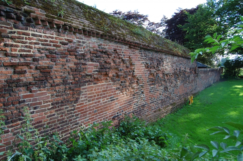
The Wilderness was originally bounded to the west and east by brick walls
which also defined part of the boundary to the castle site at this time. The
best preserved length of walling, 70m long, is situated in the south eastern
part of the site and is included in the scheduling. To the north, forming
the eastern and south eastern property boundary of Manor House School further
sections of the wall remain visible above ground, although this north western
part of the site boundary has many modern additions. In this area, therefore,
only the foundations of the 16th century wall are included in the scheduling.
In the south western part of the site, there is no surface evidence of the
boundary wall itself but its position is marked by a break of slope and it
will survive as a buried feature. At the south western and south eastern
corners of the garden are the standing remains of small towers or garden
houses. The south western tower is three storeys and has a quatrefoil plan
while the south eastern tower has two storeys and is octagonal. Both towers,
which are Listed Grade I, have large square-headed stone windows and are
included in the scheduling.
The gardens associated with Ashby Castle are thought to have originally
extended further south, beyond the southern walkway. In the area between this
walkway and the northern property boundary of Manor Close there is evidence
for two slightly raised earthworks which are parallel to the walkway and are
symmetrical with each other. There is a slight break between these features
which is thought to be the entranceway into a less formal garden area beyond.
The raised earthworks are an important aspect of the garden layout and are
included in the scheduling.
The area to the south of the raised earthworks has been incorporated within
the gardens of Manor Close and the original extent of this area of the castle
gardens is not known; this area is not included in the scheduling.
In the north western part of the site the original boundary is marked by a
continuation of the scarp further to the south (approximately 1.5m high at
this point). The flat terrace created to the east of this scarp (and now
occupied by a football pitch) may have been the original kitchen garden,
sited, as it is, to the west of the kitchen block and of any buildings
flanking the west side of the northern courtyard.
The buildings and greenhouses of Manor House Preparatory School, the ticket
building in the western part of the site and the timber sheds to the east are
excluded from the scheduling; the surfaces of all paths and driveways and that
of the tennis court, all fence posts, all walling, (with the exception of the
southern churchyard wall and the length of 16th century walling in the south
eastern part of the site), are excluded from the scheduling; the ground
beneath all these features is included.
MAP EXTRACT
The site of the monument is shown on the attached map extract.
Source: Historic England
Fortified houses were residences belonging to some of the richest and most
powerful members of society. Their design reflects a combination of domestic
and military elements. In some instances, the fortifications may be cosmetic
additions to an otherwise conventional high status dwelling, giving a military
aspect while remaining practically indefensible. They are associated with
individuals or families of high status and their ostentatious architecture
often reflects a high level of expenditure. The nature of the fortification
varies, but can include moats, curtain walls, a gatehouse and other towers,
gunports and crenellated parapets.
Their buildings normally included a hall used as communal space for domestic
and administrative purposes, kitchens, service and storage areas. In later
houses the owners had separate private living apartments, these often
receiving particular architectural emphasis. In common with castles, some
fortified houses had outer courts beyond the main defences in which stables,
brew houses, granaries and barns were located.
Fortified houses were constructed in the medieval period, primarily between
the 15th and 16th centuries, although evidence from earlier periods, such as
the increase in the number of licences to crenellate in the reigns of Edward I
and Edward II, indicates that the origins of the class can be traced further
back. They are found primarily in several areas of lowland England: in upland
areas they are outnumbered by structures such as bastles and tower houses
which fulfilled many of the same functions. As a rare monument type, with
fewer than 200 identified examples, all examples exhibiting significant
surviving archaeological remains are considered of national importance.
Ashby Castle is a well preserved example of a fortified dwelling house which
evolved over many centuries from its origins as a high status manor site into
a spectacular late medieval residence. Structural and artefactual evidence for
the original timber structures at the site and those buildings originally
situated in the north and south courtyards will survive beneath the ground
surface providing valuable information on the early occupation of the site.
The latter phases in the site's development, in particular, retain outstanding
examples of individual features which are typical of late medieval high status
residences, for example, the tower house, the kitchen building and the
gardens. The construction of the Hastings Tower and the grandiose chapel
during the 15th century clearly reflect, both in their size and in their
elaborate internal decoration, the ostentatious pride of their builder, Lord
Hastings.
The 16th century garden earthworks not only provide information for the
setting and layout of Ashby Castle, but they also reflect the trends in garden
design during this period, illustrating in particular, the emphasis on formal
ornamental gardens.
The site as a whole provides a valuable illustration of the display of wealth
and status during the late medieval period. The importance of the site is
further enhanced by the survival of medieval documentary records relating to
the occupation of the site, and antiquarian drawings of the castle ruins. As a
site in the care of the Secretary of State, and partly open to the public, it
is a valuable educational resource.
Source: Historic England
Books and journals
Jones, T L, Ashby de la Zouch Castle, (1984), 21
Jones, T L, Ashby de la Zouch Castle, (1984), 3
Jones, T L, Ashby de la Zouch Castle, (1984), 1
Pevsner, N, Williamson, E, The Buildings of England: Leicestershire and Rutland, (1984), 80-3
Source: Historic England
Other nearby scheduled monuments