Approximate Location Map
Large Map »
This site is entirely user-supported. See how you can help.
If Google Street View is available, the image is from the best available vantage point looking, if possible, towards the location of the monument. Where it is not available, the satellite view is shown instead.
Latitude: 52.7728 / 52°46'22"N
Longitude: -1.0208 / 1°1'15"W
OS Eastings: 466153.316475
OS Northings: 319915.621613
OS Grid: SK661199
Mapcode National: GBR 9MD.0QT
Mapcode Global: WHFJY.9K4N
Entry Name: Churchyard cross, All Saints' churchyard
Scheduled Date: 25 February 1951
Last Amended: 15 May 1996
Source: Historic England
Source ID: 1014510
English Heritage Legacy ID: 21643
County: Leicestershire
Civil Parish: Hoby with Rotherby
Traditional County: Leicestershire
Lieutenancy Area (Ceremonial County): Leicestershire
Church of England Parish: Upper Wreake Parish
Church of England Diocese: Leicester
The monument includes a standing stone cross located within the churchyard of
All Saints' Church, Ragdale, approximately 4m south east of the south porch.
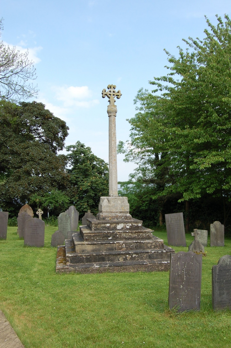
The cross is of stepped form and is medieval and later in date. It includes
the base, consisting of five steps and a socket stone, the shaft and an
ornamented head of modern date. The cross is Listed Grade II*.
The steps are square in plan and are constructed of ashlar blocks. On the
uppermost step is the socket stone, approximately 0.8m square and 0.4m high,
with moulded and chamfered corners. Set into the socket stone is a stone shaft
of square section at the base with chamfered corners tapering upwards in
octagonal section to an ornamented knop. Above this is the cross-head which
has replaced the original medieval head; it takes the form of a stone crucifix
with fleur-de-lys decoration at the end of each arm. The full height of the
cross is approximately 4.7m. It is believed to have been erected in the 14th
century and its location to the south east of the south porch suggests that it
stands in its original position.
The surface of the gravel path to the north of the cross and the grave markers
to the east and south are excluded from the scheduling, although the ground
beneath the path is included.
MAP EXTRACT
The site of the monument is shown on the attached map extract.
It includes a 1 metre boundary around the archaeological features,
considered to be essential for the monument's support and preservation.
Source: Historic England
A standing cross is a free standing upright structure, usually of stone,
mostly erected during the medieval period (mid 10th to mid 16th centuries AD).
Standing crosses served a variety of functions. In churchyards they served as
stations for outdoor processions, particularly in the observance of Palm
Sunday. Elsewhere, standing crosses were used within settlements as places for
preaching, public proclamation and penance, as well as defining rights of
sanctuary. Standing crosses were also employed to mark boundaries between
parishes, property, or settlements. A few crosses were erected to commemorate
battles. Some crosses were linked to particular saints, whose support and
protection their presence would have helped to invoke. Crosses in market
places may have helped to validate transactions. After the Reformation, some
crosses continued in use as foci for municipal or borough ceremonies, for
example as places for official proclamations and announcements; some were the
scenes of games or recreational activity.
Standing crosses were distributed throughout England and are thought to have
numbered in excess of 12,000. However, their survival since the Reformation
has been variable, being much affected by local conditions, attitudes and
religious sentiment. In particular, many cross-heads were destroyed by
iconoclasts during the 16th and 17th centuries. Less than 2,000 medieval
standing crosses, with or without cross-heads, are now thought to exist. The
oldest and most basic form of standing cross is the monolith, a stone shaft
often set directly in the ground without a base. The most common form is the
stepped cross, in which the shaft is set in a socket stone and raised upon a
flight of steps; this type of cross remained current from the 11th to 12th
centuries until after the Reformation. Where the cross-head survives it may
take a variety of forms, from a lantern-like structure to a crucifix; the more
elaborate examples date from the 15th century. Much less common than stepped
crosses are spire-shaped crosses, often composed of three or four receding
stages with elaborate architectural decoration and/or sculptured figures; the
most famous of these include the Eleanor crosses, erected by Edward I at the
stopping places of the funeral cortege of his wife, who died in 1290. Also
uncommon are the preaching crosses which were built in public places from the
13th century, typically in the cemeteries of religious communities and
cathedrals, market places and wide thoroughfares; they include a stepped base,
buttresses supporting a vaulted canopy, in turn carrying either a shaft and
head or a pinnacled spire. Standing crosses contribute significantly to our
understanding of medieval customs, both secular and religious, and to our
knowledge of medieval parishes and settlement patterns. All crosses which
survive as standing monuments, especially those which stand in or near their
original location, are considered worthy of protection.
The churchyard cross at Ragdale is a good example of a medieval standing cross
with a stepped base and octagonal shaft located in or near its original
position. Limited activity in the area surrounding the cross indicates that
archaeological deposits relating to the monument's construction and use in
this location are likely to survive intact as buried features. While most of
the cross has survived from medieval times, the subsequent restoration of the
head illustrates the continued function of the cross as a public monument and
amenity.
Source: Historic England
Other
National Monument Record, SK 61 NE 9, (1971)
Source: Historic England
Other nearby scheduled monuments