Approximate Location Map
Large Map »
This site is entirely user-supported. See how you can help.
If Google Street View is available, the image is from the best available vantage point looking, if possible, towards the location of the monument. Where it is not available, the satellite view is shown instead.
Latitude: 54.5124 / 54°30'44"N
Longitude: -2.5772 / 2°34'37"W
OS Eastings: 362728.165415
OS Northings: 513168.396499
OS Grid: NY627131
Mapcode National: GBR BJF8.V5
Mapcode Global: WH934.DV02
Entry Name: Howarcles Romano-British settlement
Scheduled Date: 24 October 1938
Last Amended: 16 February 1994
Source: Historic England
Source ID: 1011625
English Heritage Legacy ID: 22460
County: Cumbria
Civil Parish: Crosby Ravensworth
Traditional County: Westmorland
Lieutenancy Area (Ceremonial County): Cumbria
Church of England Parish: Crosby Ravensworth St Lawrence
Church of England Diocese: Carlisle
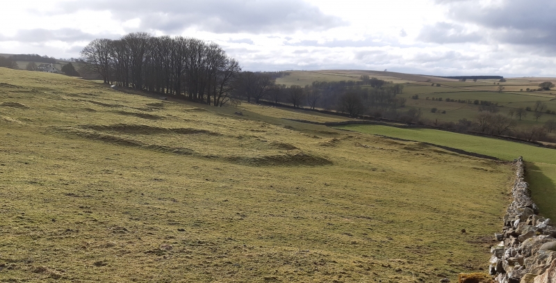
The monument is Howarcles Romano-British settlement, one of a number of such
sites surrounding the head of the Lyvennet valley. The site occupies a sloping
shelf on the west-facing hillside and includes turf-covered stone walls up to
1m high which enclose a series of rectangular and curvilinear fields
containing smaller enclosures that were stock pens. The site is divided into
two by a trackway which runs north-south along a terrace. The main block of
the settlement lies to the east of this trackway and includes a large sub-
circular enclosure 20m in diameter interpreted as the remains of a large round
house. To the west of this trackway is a small block of enclosures including
the remains of a much smaller round house, this one having a diameter of 9m.
The site would have been in use during the Roman conquest of the north. It
lies within an area once occupied by the Carvetii tribe. All modern field
boundaries and gateposts are excluded from the scheduling, but the ground
beneath these features is included.
MAP EXTRACT
The site of the monument is shown on the attached map extract.
Source: Historic England
In Cumbria and Northumberland several distinctive types of native settlements
dating to the Roman period have been identified. The majority were small, non-
defensive, enclosed homesteads or farms. In many areas they were of stone
construction, although in the coastal lowlands timber-built variants were also
common. In much of Northumberland, especially in the Cheviots, the enclosures
were curvilinear in form. Further south a rectangular form was more common.
Elsewhere, especially near the Scottish border, another type occurs where the
settlement enclosure was `scooped' into the hillslope. Frequently the
enclosures reveal a regularity and similarity of internal layout. The standard
layout included one or more stone round-houses situated towards the rear of
the enclosure, facing the single entranceway. In front of the houses were
pathways and small enclosed yards. Homesteads normally had only one or two
houses, but larger enclosures could contain as many as six. At some sites the
settlement appears to have grown, often with houses spilling out of the main
enclosure and clustered around it. At these sites up to 30 houses may be
found. In the Cumbrian uplands the settlements were of less regimented form
and unenclosed clusters of houses of broadly contemporary date are also known.
These homesteads were being constructed and used by non-Roman natives
throughout the period of the Roman occupation. Their origins lie in settlement
forms developed before the arrival of the Romans. These homesteads are common
throughout the uplands where they frequently survive as well-preserved
earthworks. In lowland coastal areas they were also originally common,
although there they can frequently only be located through aerial photography.
All homestead sites which survive substantially intact will normally be
identified as nationally important.
Howarcles is a good example of a small Romano-British native settlement with
attached fields and enclosures. Its earthworks survive well and preserve much
detail of the layout of the settlement. It is one of a group of similar
settlements at the head of the Lyvennet valley and will contribute to any
study of Romano-British settlement patterns in this area.
Source: Historic England
Books and journals
Higham, N, Jones, B, The Carvetti, (1985), 132-3
Higham, N, The Northern Counties to AD 1000, (1986), 192
Alcock, L, 'Archaeologia Cambrensis' in Gwyr Y Gogledd, , Vol. CXXXII, (1983), 4
Collingwood, R G, 'Trans Cumb & West Ant & Arch Soc. New Ser.' in Prehistoric Settlements Near Crosby Ravensworth, , Vol. XXXIII, (1936), 216
Other
Ebbatson,L., MPP Single Mon Class Descriptions - Romano-British Farmsteads, (1989)
Source: Historic England
Other nearby scheduled monuments