Approximate Location Map
Large Map »
This site is entirely user-supported. See how you can help.
If Google Street View is available, the image is from the best available vantage point looking, if possible, towards the location of the monument. Where it is not available, the satellite view is shown instead.
Latitude: 52.7332 / 52°43'59"N
Longitude: 0.0833 / 0°5'0"E
OS Eastings: 540766.628934
OS Northings: 317101.006736
OS Grid: TF407171
Mapcode National: GBR L0V.PWQ
Mapcode Global: WHJP2.7KYH
Entry Name: Boundary cross, Manor Hill Corner
Scheduled Date: 6 January 1995
Source: Historic England
Source ID: 1010688
English Heritage Legacy ID: 22683
County: Lincolnshire
Civil Parish: Sutton St James
Traditional County: Lincolnshire
Lieutenancy Area (Ceremonial County): Lincolnshire
Church of England Parish: Tydd St Mary
Church of England Diocese: Lincoln
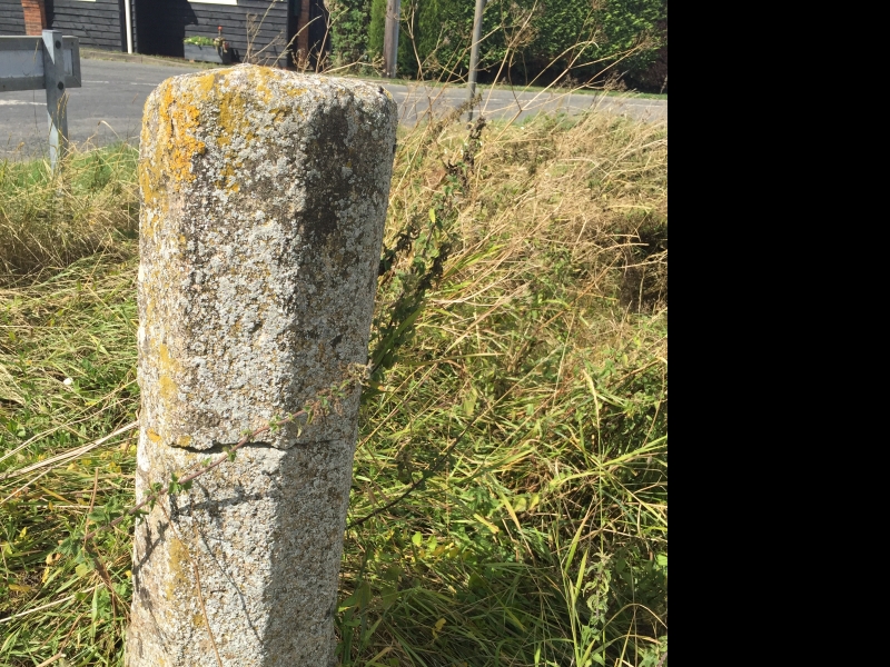
The monument includes a standing stone cross located at Manor Hill Corner. The
cross stands on a grass verge on the north east side of a road junction at the
southern end of the Master Dike, a drainage channel which runs along the
parish boundary between Tydd St Mary and Sutton St James. The cross is
medieval in date and is constructed of limestone. The monument includes the
base, comprising a socket stone, and part of the shaft.
The socket stone is constructed from a single limestone block of rectangular
section. On the north side it stands up to 0.28m above the ground surface,
which slopes down towards the Master Dike; on the south side it is partially
buried, the top of the stone lying approximately level with the ground surface
of the roadside verge. The upper edge of the stone is chamfered. Set into the
centre of the socket stone is a shaft fragment, nearly square in section at
the base rising through moulded and chamfered corners in tapering octagonal
section to a height of 1.1m. The cross is Listed Grade II.
MAP EXTRACT
The site of the monument is shown on the attached map extract.
It includes a 1 metre boundary around the archaeological features,
considered to be essential for the monument's support and preservation.
Source: Historic England
A standing cross is a free standing upright structure, usually of stone,
mostly erected during the medieval period (mid 10th to mid 16th centuries AD).
Standing crosses served a variety of functions. In churchyards they served as
stations for outdoor processions, particularly in the observance of Palm
Sunday. Elsewhere, standing crosses were used within settlements as places for
preaching, public proclamation and penance, as well as defining rights of
sanctuary. Standing crosses were also employed to mark boundaries between
parishes, property, or settlements. A few crosses were erected to commemorate
battles. Some crosses were linked to particular saints, whose support and
protection their presence would have helped to invoke. Crosses in market
places may have helped to validate transactions. After the Reformation, some
crosses continued in use as foci for municipal or borough ceremonies, for
example as places for official proclamations and announcements; some were the
scenes of games or recreational activity.
Standing crosses were distributed throughout England and are thought to have
numbered in excess of 12,000. However, their survival since the Reformation
has been variable, being much affected by local conditions, attitudes and
religious sentiment. In particular, many cross-heads were destroyed by
iconoclasts during the 16th and 17th centuries. Less than 2,000 medieval
standing crosses, with or without cross-heads, are now thought to exist. The
oldest and most basic form of standing cross is the monolith, a stone shaft
often set directly in the ground without a base. The most common form is the
stepped cross, in which the shaft is set in a socket stone and raised upon a
flight of steps; this type of cross remained current from the 11th to 12th
centuries until after the Reformation. Where the cross-head survives it may
take a variety of forms, from a lantern-like structure to a crucifix; the more
elaborate examples date from the 15th century. Much less common than stepped
crosses are spire-shaped crosses, often composed of three or four receding
stages with elaborate architectural decoration and/or sculptured figures; the
most famous of these include the Eleanor crosses, erected by Edward I at the
stopping places of the funeral cortege of his wife, who died in 1290. Also
uncommon are the preaching crosses which were built in public places from the
13th century, typically in the cemeteries of religious communities and
cathedrals, market places and wide thoroughfares; they include a stepped base,
buttresses supporting a vaulted canopy, in turn carrying either a shaft and
head or a pinnacled spire. Standing crosses contribute significantly to our
understanding of medieval customs, both secular and religious, and to our
knowledge of medieval parishes and settlement patterns. All crosses which
survive as standing monuments, especially those which stand in or near their
original location, are considered worthy of protection.
The medieval boundary cross at Manor Hill Corner, Tydd St Mary, is a good
example of a standing boundary cross with a quadrangular base and octagonal
shaft. Situated at the former south eastern corner of the parish of Sutton St
James it is believed to stand in or near its original position. Limited
disturbance of the area immediately surrounding the cross indicates that
archaeological deposits relating to the monument's construction and use are
likely to survive intact. The cross has been little altered in modern times
and has continued in use as a landmark from medieval times to the present day.
Source: Historic England
Books and journals
Davies, D S, 'Lincolnshire Notes & Queries' in Ancient Stone Crosses in Lindsey and Holland Divisions of Lincs, , Vol. XIII no7, (1915), 218
Other
account of maps seen, 16th c + later, Losco-Bradley, P.M., FMW Report, (1988)
parish clerk, Bowser, B, (1994)
Source: Historic England
Other nearby scheduled monuments