Approximate Location Map
Large Map »
This site is entirely user-supported. See how you can help.
If Google Street View is available, the image is from the best available vantage point looking, if possible, towards the location of the monument. Where it is not available, the satellite view is shown instead.
Latitude: 52.7549 / 52°45'17"N
Longitude: -0.532 / 0°31'55"W
OS Eastings: 499169.691758
OS Northings: 318491.317753
OS Grid: SK991184
Mapcode National: GBR FTJ.B96
Mapcode Global: WHGLH.S0VT
Entry Name: Castle Bytham Castle, associated town defences and ponds
Scheduled Date: 22 March 1949
Last Amended: 7 August 1996
Source: Historic England
Source ID: 1014681
English Heritage Legacy ID: 22714
County: Lincolnshire
Civil Parish: Castle Bytham
Built-Up Area: Castle Bytham
Traditional County: Lincolnshire
Lieutenancy Area (Ceremonial County): Lincolnshire
Church of England Parish: Castle Bytham St James
Church of England Diocese: Lincoln
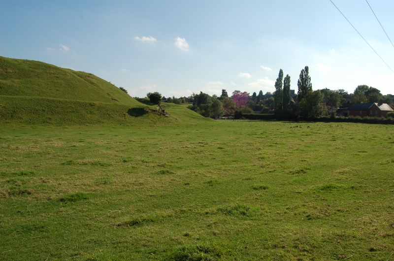
The monument includes Castle Bytham Castle, a motte and bailey castle believed
to have been constructed in the late 11th century by Drogo, brother-in-law of
William I. The castle is first directly referred to in documentary sources of
the later 12th century, when it was held by William, 3rd Earl of Albemarle;
soon after it was granted to William de Colvile, and then in 1215-16 to
William de Fortibus. In the winter of 1220-21 Fortibus fortified the castle
against King Henry III, who successfully besieged it and ordered its
destruction. The manor was returned to the Colviles, who rebuilt and
re-occupied the castle until the late 14th century when it was inhabited by
Lady Basset, grandmother of Henry V. In the 15th century it fell into decline
and by 1544 was in ruins; it was subsequently dismantled for building stone
and by 1906 no stonework was visible above ground.
The castle remains are located on a natural spur projecting westwards into the
valley of the River Tham which runs from north to south east through the
village. The motte is constructed on the tip of the spur while the bailey,
which is L-shaped, lies on the high ground to the south and east of it. The
earthwork remains of the castle are adjoined by those of an elaborate water
control system constructed on the original course of the river and composed of
a series of artificial channels and ponds linked by dams and sluices; this
system served a combination of defensive, symbolic and economic functions
associated with the castle, including fish rearing and milling. To the south
west of this complex of earthworks is the site of a settlement contemporary
with the castle, now occupied by the present village; on its south eastern
side are the remains of part of a substantial stone wall by which it was
formerly defended. The monument includes the earthwork and buried remains of
the motte and bailey castle, its water control system and the defences of its
associated settlement, which are protected within three separate areas.
The motte takes the form of a conical flat topped mound standing to a height
of approximately 18m above the river valley. The top of the mound, which is
oval, is wholly occupied by the remains of a quadrangular shell keep. These
remains take the form of earth covered stone walls defining a series of rooms
of largely rectangular shape ranged around a central courtyard. The ranges
vary in width, the most substantial structures being to the west and south.
Depressions in the south range indicate the presence of basements which are
thought to have been part of a strong tower or donjon. Structures extending
southwards from the south range onto the side of the motte include the remains
of a postern gate which were partly excavated in the 19th century. The
principal gateway to the keep was situated at the south eastern corner where
there is an opening leading eastwards from the central courtyard and passing
between the remains of two substantial stone towers built onto the side of the
motte.
The motte is surrounded by a deep ditch with, on three sides, a large external
bank surmounted by the remains of a stone curtain wall which incorporates
mural towers at its south western and north western corners. To the east of
the motte, and connected to it by a narrow causeway across the ditch, is a
mound of similar height; the top, which measures about 10m in diameter, is
occupied by the earth covered remains of a hexagonal tower. This tower is
identified as an internal barbican which served as an additional defence
between the motte and the bailey. The barbican is also surrounded by a ditch,
separated from that of the motte by an earthen bank which at each end meets
the remains of a gateway in the curtain wall; that on the north leads directly
onto the bailey, while that on the south leads over another ditch which runs
along the south side of both the motte and the barbican.
Standing on the high ground to the south and east of the motte are the
earthwork remains of the bailey, an area of reversed L-shape about 50m wide on
the east and 40m wide on the south. On the inner, north western edge are the
remains of a stone wall; on the outer, south eastern edge it is protected by a
substantial earthen bank and a wide external ditch. This ditch continues
around the north and west ends, along which is a stone wall contiguous with
the main curtain wall surrounding the motte. The bailey is divided into two
parts by the remains of a stone wall running roughly east-west from the
barbican ditch, with an entrance at its western end; to the north is a walled
inner courtyard, and to the south a larger outer courtyard. In both courtyards
are the earth covered remains of ranges of stone buildings, which are believed
to have included domestic, agricultural and service buildings such as stables,
barns, brewhouses and lodgings. The principal surviving entrance to the bailey
is from the east where the remains of a large stone gateway lead into the
outer courtyard from a causeway over the external ditch.
The curtain wall along the northern end of the bailey is abutted to the north
by the remains of a rectangular building which lies at right-angles to it on
the inner scarp of the ditch; from the outside edge of the ditch a stone wall
continues on the same alignment for a distance of nearly 80m to the river. The
wall survives as an earthwork approximately 0.5m in height and terminates in a
small mound about 1m high which is thought to represent the remains of a
tower. Together, the wall and building serve as part of the defensive scheme
of the castle. Running parallel with the wall at a distance of about 30m to
the east are a linear bank and ditch marking a small rectangular enclosure
associated with the castle, probably used for keeping animals.
To the north and west of the motte and bailey earthworks is a low, flat area
known as Castle Yard. This area represents the remains of a large pool
constructed by channelling the river towards the western side of the valley
and controlling the water level of the pool by a number of sluices. This pool
formed part of a series of water control features contemporary with the castle
which served to augment the defences both practically and symbolically and to
provide water for a variety of economic activities. There are two causeways
across the pool which would have been used in medieval and post-medieval times
when the pool was dry. This water control system continues south of the castle
where there are the earthwork remains of a large rectangular fishpond aligned
east-west on the south side of the river and measuring approximately 50m by
30m, subdivided into two tanks by a rectangular central island. The pond, now
dry, is about 3m deep; along its western side is a broad bank, up to 0.5m high
and 10m wide, with an inlet channel at each end through which water was fed
into the pond from the low ground on the west. There is another bank about
0.5m in height along the northern side of the pond. To the north west of the
pond is a shallow rectangular depression, thought to be the remains of a
smaller fishpond, and a raised platform where timber buildings associated with
fish rearing are thought to have been located; to the east of the main
fishpond is another depression about 0.5m deep which is believed to be part of
another pond.
To the south east of the castle are the earthwork remains of a second large
pool, now dry, formed behind an earthwork dam built across the original course
of the river. It is dammed at its southern end by a substantial earth and
stone bank about 2m high, 50m long and 6m wide at the top; at its eastern end
is a gap of about 5m, beyond which is a narrower, L-shaped bank meeting the
scarp which defines the eastern side of the pool. The north end of this bank
is overlain by a trackway. The western side of the pool is formed by a
retaining bank approximately 1m high, and the eastern side by a levelled
terrace built against the natural scarp. The pool formed behind the dam
covered an L-shaped area at least 350m long and up to 80m wide. The damming of
the pool is believed to date from the medieval period when a watermill
associated with the castle is thought to have been situated at the dam, with
the water wheel perhaps occupying the gap now left between the two banks.
Running along the south and west sides of the pool is the water channel in
which the river now runs; this is a man-made channel contemporary with the
construction of the pool and served as a bypass leat to carry water away from
the pool at times of increased flow. The north western part of the pool is
bounded by a levelled terrace, including a trackway and building platforms
believed to be medieval in origin. At the eastern end of the terrace are the
earthwork remains of a small house and garden constructed in the early post-
medieval period. Buildings in this area would have been associated with
economic activity such as fish rearing or milling.
The defensive scheme associated with the motte and bailey castle was completed
in the medieval period by the construction of a `town wall' to delineate and
protect an area of settlement to the south west of the castle. Running south
westwards up the slope from the fishpond complex is a linear bank,
approximately 1.5m high and 6m wide, which represents the remains of this
wall. It runs for over 160m to the edge of Station Road and then follows
the edge of the road for approximately 14m to the earth covered remains of a
small building. These features are thought to be associated with a gateway.
All fences, gates and outbuildings are excluded from the scheduling, although
the ground beneath these features is included.
MAP EXTRACT
The site of the monument is shown on the attached map extract.
Source: Historic England
Motte and bailey castles are medieval fortifications introduced into Britain
by the Normans. They comprised a large conical mound of earth or rubble, the
motte, surmounted by a palisade and a stone or timber tower. In a majority of
examples an embanked enclosure containing additional buildings, the bailey,
adjoined the motte. Motte castles and motte-and-bailey castles acted as
garrison forts during offensive military operations, as strongholds, and, in
many cases, as aristocratic residences and as centres of local or royal
administration. Built in towns, villages and open countryside, motte and
bailey castles generally occupied strategic positions dominating their
immediate locality and, as a result, are the most visually impressive
monuments of the early post-Conquest period surviving in the modern landscape.
Over 600 motte castles or motte-and-bailey castles are recorded nationally,
with examples known from most regions. As one of a restricted range of
recognised early post-Conquest monuments, they are particularly important for
the study of Norman Britain and the development of the feudal system. Although
many were occupied for only a short period of time, motte castles continued to
be built and occupied from the 11th to the 13th centuries, after which they
were superseded by other types of castle.
The remains of the motte and bailey castle at Castle Bytham survive in good
condition. Part excavation of the site in the 19th century demonstrated the
high level of survival of structural and artefactual remains while leaving the
majority of deposits intact. The castle itself is of a particularly rare type
in having an internal barbican, one of very few examples in this country; the
construction, occupation and siege of the castle are well documented and
provide the opportunity to identify specific archaeological deposits with
recorded historical events. The water control system and settlement defences
associated with the castle are outstanding in Lincolnshire and survive in
excellent condition, having been relatively unaltered since medieval times.
The archaeological relationships between the complementary elements of the
castle will show us how a high status establishment of this type functioned,
both as a defensive system and as an economic, social and symbolic force in
the local and regional landscape.
Source: Historic England
Books and journals
Chandler, J, John Lelands Itinerary: Travels in Tudor England, (1993), 287
Dolby, , A Short Account of the Church, Castle and Village of Castle B..., (1900)
Kenyon, J, Medieval Fortifications, (1990), 78-82
Wild, J, The History of Castle Bytham, (1871)
Other
Crawford, R A, (1995)
Downman, EA, Castle Bytham 6 3/4 miles w. by s. of Bourn Lincolnshire, 1906, manuscript
letter from NRA 19 Oct 1995, Anglian Water, Castle Bytham and Little Bytham Flood Alleviation Scheme, (1980)
report by SK Community Archaeologist, Waller, R, Castle Bytham Fishponds, (1994)
Source: Historic England
Other nearby scheduled monuments