Approximate Location Map
Large Map »
This site is entirely user-supported. See how you can help.
If Google Street View is available, the image is from the best available vantage point looking, if possible, towards the location of the monument. Where it is not available, the satellite view is shown instead.
Latitude: 50.6043 / 50°36'15"N
Longitude: -4.4409 / 4°26'27"W
OS Eastings: 227369.500903
OS Northings: 81134.452161
OS Grid: SX273811
Mapcode National: GBR NG.CC3R
Mapcode Global: FRA 17LG.MQW
Entry Name: Medieval wayside cross 550m north-west of Lewannick church
Scheduled Date: 18 July 1973
Last Amended: 22 October 1993
Source: Historic England
Source ID: 1007757
English Heritage Legacy ID: 24257
County: Cornwall
Civil Parish: Lewannick
Traditional County: Cornwall
Lieutenancy Area (Ceremonial County): Cornwall
Church of England Parish: Lewannick
Church of England Diocese: Truro
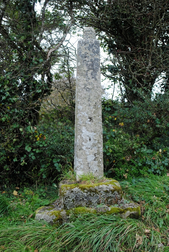
The monument includes a medieval wayside cross, locally known as the Swearing
Cross, situated north-west of Lewannick village on an early route linking
villages near the north-east edge of Bodmin Moor, near that route's junction
with the main east-west road from Launceston to Bodmin.
This cross survives as a granite shaft set in a double-stepped base on the
north-east verge of the road, the shaft having a distinct lean away from the
road. The head of the cross is missing. The shaft is undecorated and rises
1.66m from its emergence at the base. It is of nearly square section, 0.26m
thick and tapering slightly from 0.3m wide at the base to 0.25m wide near the
top. On top of the shaft is a large rounded tenon joint by which the head was
formerly fixed. The base of the shaft tapers inwards as it enters the top step
of the base. The top step is almost square, measuring 0.64m by 0.63m, and is
0.24m high, with roughly rounded top corners. The bottom step of the base is a
coarsely shaped boulder, sub-rectangular in plan, measuring 1.16m north-south
and 1m east-west, and rises 0.36m above ground level.
The cross is situated near the brow of a hill by a road linking Lewannick
village to the important major east-west route between Bodmin and Launceston.
This road passing through Lewannick forms part of an early thoroughfare from
south-east Cornwall to the county's north coast. The cross also marks one of
the main thoroughfares within Lewannick to its parish church, where there are
several early Christian monuments.
An area 2m wide beyond the base of the cross is included in the scheduling to
ensure its protection. Within this area, the metalled surface of the modern
road passing south-west of the cross is excluded from the scheduling, although
the ground beneath is included.
MAP EXTRACT
The site of the monument is shown on the attached map extract.
It includes a 2 metre boundary around the archaeological features,
considered to be essential for the monument's support and preservation.
Source: Historic England
Wayside crosses are one of several types of Christian cross erected during the
medieval period, mostly from the 9th to 15th centuries AD. In addition to
serving the function of reiterating and reinforcing the Christian faith
amongst those who passed the cross and of reassuring the traveller, wayside
crosses often fulfilled a role as waymarkers, especially in difficult and
otherwise unmarked terrain. The crosses might be on regularly used routes
linking ordinary settlements or on routes having a more specifically religious
function, including those providing access to religious sites for parishioners
and funeral processions, or marking long-distance routes frequented on
pilgrimages.
Over 350 wayside crosses are known nationally, concentrated in south-west
England throughout Cornwall and on Dartmoor where they form the commonest type
of stone cross. A small group also occurs on the North York Moors. Relatively
few examples have been recorded elsewhere and these are generally confined to
remote moorland locations.
Outside Cornwall almost all wayside crosses take the form of a 'latin' cross,
in which the cross-head itself is shaped with the projecting arms of an
unenclosed cross. In Cornwall wayside crosses vary considerably in form and
decoration. The commonest type includes a round, or 'wheel', head on the faces
of which various forms of cross or related designs were carved in relief or
incised, the spaces between the cross arms possibly pierced. The design was
sometimes supplemented with a relief figure of Christ and the shaft might bear
decorative panels and motifs. Less common forms in Cornwall include the
'Latin' cross and, much rarer, the simple slab with a low relief cross on both
faces. Rare examples of wheel-head and slab-form crosses also occur within the
North York Moors group. Most wayside crosses have either a simple socketed
base or show no evidence for a separate base at all.
Wayside crosses contribute significantly to our understanding of medieval
religious customs and sculptural traditions and to our knowledge of medieval
routeways and settlement patterns. All wayside crosses which survive as earth-
fast monuments, except those which are extremely damaged and removed from
their original locations, are considered worthy of protection.
This cross near Lewannick has survived reasonably well despite lacking its
head and remains in its original location. The double-stepped base and the
large tenon for mounting the head are unusual features. Its location
demonstrates well some of the roles of wayside crosses in marking both major
cross-country routes and the ways within the parish to the church. Its local
name, the Swearing Cross, shows how wayside crosses may also accumulate wider
traditions among the communities they served.
Source: Historic England
Other
consulted 1993, Cornwall SMR entry for PRN 17584,
Title: 1:50000 Ordnance Survey Map; Plymouth & Launceston Area (Landranger Series 201)
Source Date: 1988
Author:
Publisher:
Surveyor:
Source: Historic England
Other nearby scheduled monuments