Approximate Location Map
Large Map »
This site is entirely user-supported. See how you can help.
If Google Street View is available, the image is from the best available vantage point looking, if possible, towards the location of the monument. Where it is not available, the satellite view is shown instead.
Latitude: 55.334 / 55°20'2"N
Longitude: -1.5395 / 1°32'22"W
OS Eastings: 429309.136055
OS Northings: 604529.959865
OS Grid: NU293045
Mapcode National: GBR K6PR.HR
Mapcode Global: WHC21.B648
Entry Name: Monastic cell and medieval tower on Coquet Island
Scheduled Date: 19 August 1938
Last Amended: 16 July 1996
Source: Historic England
Source ID: 1014734
English Heritage Legacy ID: 24613
County: Northumberland
Civil Parish: Hauxley
Traditional County: Northumberland
Lieutenancy Area (Ceremonial County): Northumberland
Church of England Parish: Amble
Church of England Diocese: Newcastle
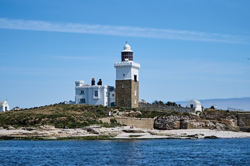
The monument includes the site of a pre-Conquest monastic cell founded c.AD
684, and a pre-AD 1125 Benedictine foundation located on Coquet Island. The
cell comprised a domestic range with a vaulted undercroft and a chapel
attached to the east. It survives as an east-west range of medieval stone
buildings, probably 15th century in date, which are incorporated into 19th
century buildings associated with a lighthouse. To the south west stand the
remains of a medieval tower which has been incorporated in the lighthouse
tower. It is linked to the east-west range by a building of 1841. The medieval
parts of the building can be differentiated externally from the 19th century
work as only the latter are now whitewashed.
The east-west range measures 28.5m long and divides into two parts of
approximately equal length. The ground floor of the western section remains
virtually unaltered with its four centred barrel vault, having no
communication with the 19th century upper floor which extends over most of its
length. Two cross walls divide the ground floor into three chambers. A
chamfered four centred doorway at the west end of the south wall opens into
the west and smallest chamber. On the inner face of the wall immediately east
of the door is the blocked foot of a stone newel stair, contained in an
external buttress-like projection. In the west wall, now obscured by fuel
tanks, are two adjacent blocked doorways, the northern one retaining its
arched head. These imply an adjacent structure, replaced by the 1841 building,
which must have linked the east-west range with the tower. The exact size and
extent of this adjacent building is not yet fully understood and thus its site
is not included in the scheduling. The central and largest chamber is entered
by a rough doorway set centrally in the western cross wall. The cross wall is
0.56m wide with a rubble fill and the external walls are 0.8m wide. A single
window is located on the south side which is probably an enlargement of an
original opening; it has an internal splay and measures 0.9m by 0.9m
externally and 1.35m by 1.05m internally. There is no opening through the
eastern cross wall, against which is set a post-medieval fireplace which
appears to pre-date mid-19th century remodelling. The east chamber is entered
by a doorway in its east wall from the 19th century cottage beyond. It is lit
by two deeply splayed openings, each measuring 0.6m by 0.88m, in the north and
south walls. At first floor level the only fragment of this part of the range
to survive is the east end of its south wall, with a small square headed
window.
The eastern part of the range is narrower than the western and is incorporated
in the 19th century lighthouse keeper's cottage; original walling survives on
the north and east sides. On the south the cottage wall is set slightly
forward of the western part of the range which, at its extreme east end,
partly masked by the cottage wall, shows some large dressed blocks which
appear to be the west jamb of an original doorway. The surviving fragment of
the east end projects above the cottage roof and contains the sill and double
chamfered jambs of a large window of a single storeyed building, probably the
chapel. Toothing on the external wall face to the north of the window probably
indicates a buttress position. At the west end of the north wall is a
projecting turret, interpreted as a sacristy or room where sacred items are
kept. It measures 2.4m square, is built of more thinly coursed stonework than
the main range and is probably a medieval addition. The ground floor of the
turret has no openings and may be of solid masonry. The first floor is carried
on an oversailing chamfered course, a little above which squinches or small
arches across the angle of a square tower link its side walls with that of the
main range behind. Internally, the walls of the first floor chamber in the
turret stand up to 1.5m high and show several features of interest: the east
jamb with drawbar tunnel, remains of a doorway into the chamber, and the lower
parts of windows in both east and west walls. In the north east corner is a
rectangular shaft or flue in the wall thickness and, on the north, remains of
what appear to be twin drains running through the wall. Because of the extent
of the medieval fabric in it, the whole of the east-west range of buildings,
as described above, is included in the scheduling.
The tower measures externally 5.6m north-south by 6.8m east-west. The
medieval squared masonry, laid in irregular courses, extends to the top of the
second floor. Above this is a setback and a 19th century top stage carrying a
corbelled out embattled parapet and the lighthouse lantern. A 19th century
engraving by D Harding shows a tower of at least four storeys and further
buildings to the left. If Harding's engraving is to be believed, the 19th
century work must replace medieval fabric. The existing windows are all 19th
century in their present form, but older blocked square headed windows are
visible on east, north and south faces. Internally, on the ground floor is
a vault which appears to be medieval. The tower is interpreted as a defensible
retreat rather than a conventional tower house. Only the medieval remains,
extending to the top of the second floor, are included in the scheduling.
The earliest documentary reference to the island is in AD 684 when St
Cuthbert met Elfleda, sister of King Egfrith and abbess of Whitby on the
island. There was presumably a monastic establishment on the island already
when this meeting took place. A number of stray finds discovered on the island
also testify to its early occupation: among these were a ninth century ring
and an enamelled metal ornament. An Anglo-Saxon cross-decorated slab was found
on the beach below the lighthouse in 1969. It is now in the Department of
Archaeology, University of Durham. It is dated to the last quarter of the
seventh to the first quarter of the eigth century AD. An Anglo-Saxon cross-
decorated slab was found on the beach below the lighthouse in 1969. It is now
in the Department of Archaeology, University of Durham. It is dated to the
last quarter of the seventh century to the first quarter of the eigth century
AD. After the Norman Conquest, Robert de Mowbray gave the island to the prior
and convent of Tynemouth. In the early 13th century a hermit named Martin
built a windmill on the island which was ordered to be knocked down by Robert
fitz Roger, lord of Warkworth. In 1415 a list of fortalices stated that the
tower of Coket-eland belonged to the prior of Tynemouth. In 1442 Henry, second
Earl of Northumberland, made a grant to Tynemouth on condition that two monks
should celebrate masses within the chapel on Coquet Island for his and his
wife's souls. After the Dissolution the monastic group of buildings fell into
disrepair and were used by coin counterfeiters. By 1730 the buildings
consisted of the remains of houses and a tower. Mackenzie's history, dating to
1825, refers to the ruins being `partly converted into a dwelling house and a
lighthouse'. In 1841 a major rebuilding scheme by Trinity House converted the
monastic remains into a lighthouse complex. The lighthouse and attached
buildings are Grade II* Listed Buildings.
MAP EXTRACT
The site of the monument is shown on the attached map extract.
Source: Historic England
From the time of St. Augustine's mission to establish Christianity in AD 597
monasticism formed an important facet of both religious and secular life in
the British Isles. In addition to the larger monastic sites housing
communities of monks, a range of smaller monastic settlements (sometimes known
as `cells') also developed. These were used as recluse sites by small groups
of ecclesiastics or sometimes by a single monk. The majority of these cells
were deliberately located in remote or isolated places, including islands, to
ensure that their inhabitants were well away from the pressures of secular
life and could therefore focus more clearly on religious activities and
contemplation. The buildings of these sites were usually simple and small. A
small chapel may have been provided, as well as a simple hut for shelter.
Stone or wooden crosses were often erected. Cemeteries were also a common
feature as many early ecclesiastics retreated to such cells towards the end of
their lives; burials were often marked by cross-incised stone slabs. The
majority of cells were established in the pre-Viking period, although many
remained in use for several centuries. At some, life was significantly
disrupted by the Viking raids which began in the early ninth century. The
slight nature of the original structures has meant that it is often the case
that little has survived the passage of time and these sites are often now
difficult to identify on the ground. Many are known almost wholly from
documentary evidence. Some cells were revitalised by or re-established during
the post-Conquest period when larger, more elaborate and permanent structures
were built, usually including stone-built structures not dissimilar to those
found elsewhere on larger contemporary monastic sites. Whilst often still used
for the purposes of retreat and contemplation, those cells associated with
renowned early saints also developed a role as pilgrimage centres.
As a rare monument type which provides an important insight into early
ecclesiastical life, all positively identified examples of pre-Conquest
monastic cells will be identified as nationally important. Post-Conquest
monastic examples are also rare and a significant number of these will also be
identified as nationally important.
Tower houses are a type of defensible house particularly characteristic of
the borderlands of England and Scotland. Virtually every parish had at least
one of these buildings. Solitary tower houses comprise a single square or
rectangular `keep' several stories high, with strong barrel-vaults tying
together massive outer walls. Many towers had stone slab roofs, often with a
parapet walk. Access could be gained through a ground floor entrance or at
first floor level where a doorway would lead directly to a first floor hall.
Solitary towers were normally accompanied by a small outer enclosure defined
by a timber or stone wall and called a barmkin. Tower houses were being
constructed and used from at least the 13th century to the end of the 16th
century. They provided prestigious defended houses permanently occupied by the
wealthier and aristocratic members of society. As such, they were important
centres of medieval life. The need for such secure buildings relates to the
unsettled and frequently war-like conditions which prevailed in the Borders
throughout much of the medieval period. Around 200 examples of tower houses
have been identified of which less than half are of the free-standing or
solitary tower type. All surviving solitary towers retaining significant
medieval remains will normally be identified as nationally important.
The monastic site on Coquet Island survives well within the 19th century
buildings and is one of the few where the archaeology of the period can be
readily appreciated by visitors. The incorporation of a tower into a
small monastic site is unusual. It will aid research into the early Christian
period in Northumbria.
Source: Historic England
Books and journals
Bates, C J, The Border Holds of Northumberland, (1891), 19
Graham, F, The Castles of Northumberland, (1976), 115
Mackenzie, E, An Historical View of the County of Northumberland, (1825), 121
Ryder, P, The Remains of the Monastic Cell on Coquet Island, (1987)
Other
parish of Hauxley, Department of the Environment, List of Buildings of Special Architectural or Historic Interest, District of Alnwick, Northumberland, (1988)
Source: Historic England
Other nearby scheduled monuments