Approximate Location Map
Large Map »
This site is entirely user-supported. See how you can help.
If Google Street View is available, the image is from the best available vantage point looking, if possible, towards the location of the monument. Where it is not available, the satellite view is shown instead.
Latitude: 55.6861 / 55°41'9"N
Longitude: -1.8078 / 1°48'27"W
OS Eastings: 412184.67354
OS Northings: 643636.940619
OS Grid: NU121436
Mapcode National: GBR H2TP.FJ
Mapcode Global: WHC05.6BFV
Entry Name: Early medieval farmstead at Green Shiel, Holy Island
Scheduled Date: 3 July 1997
Source: Historic England
Source ID: 1015632
English Heritage Legacy ID: 24655
County: Northumberland
Civil Parish: Holy Island
Traditional County: Northumberland
Lieutenancy Area (Ceremonial County): Northumberland
Church of England Parish: Holy Island St Mary the Virgin
Church of England Diocese: Newcastle
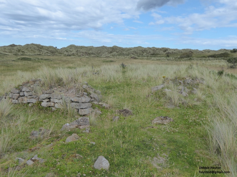
This monument includes a farmstead dated to the early medieval period. The
stone built foundations of five rectangular buildings have been uncovered by
excavation within the dune system on the north coast of Holy Island. The
buildings are connected by a number of linking walls, banks radiate from the
settlement and a possible boundary bank lies to the north. The remains of
ridge and furrow cultivation are visible to the south, however, sand dunes
have obscured the relationship between this and the settlement and the field
system is therefore not included within the scheduling. The site has recently
been the subject of a programme of research and excavation carried out by
Leicester University.
The site lies close to the north shore of Holy Island. It occupies an
area of open, level ground known as the Green Shiel. The site is separated
from the coast to the north by a ridge of steep dunes, a further ridge of
dunes lies immediately to the south of the site. Two 19th century waggonways
traverse the Green Shiel on its eastern and western sides.
The site comprises a group of at least five long, rectangular buildings
which are aligned either east-west or north-south, thus forming a rough cross
shape. All the buildings occupy ridges of slightly raised ground, it is not
clear whether these ridges have been deliberately constructed, or whether they
are the result of the surrounding land having been eroded away. A pair of
buildings, aligned east-west, lie to the east of the north-south axis.
Although divided by a massive central wall, the two buildings appear to be of
one construction, and are in effect one very large building which has been
divided internally. The easternmost of this pair measures 19m by 4.5m
internally, the lower courses of its massive drystone walls are up to 1.75m
wide and survive up to 1m high. A well constructed doorway, approximately 1m
wide, is located at the eastern end of the north wall and a further two doors
are located at the west end of the building, in the north and south walls,
although it would appear that not all of these were in use at the same time. A
stone lined feature, tentatively identified as a drain, was identified by
excavation as running in a south westerly direction from the south east corner
of the building. Excavation also revealed that the building had paved floors
dating to two different periods of occupation. Outside the building, a low and
very spread bank of sand and stone, 0.2m high and up to 3m wide, extends from
the north east corner of the building, eastwards, for a length of 51m. The
westermost of the pair of buildings measures 20m by 5m. It has suffered more
severely from stone robbing, with only the southern wall still retaining any
facing stones. A well preserved section of paving was found at the eastern end
of the building and post holes for roof supports were identified, running
centrally down the mid and western sections of the building. Outside the
building, a very broad bank up to 5m wide and 21m long extends northwards from
the north west corner of the building. Immediately to the west of this pair of
buildings, a further two buildings are aligned along the north-south axis of
the settlement. The southernmost of these buildings measures 18.5m by 4m
internally. The drystone walls are up to 1.2m wide and visible sections stand
up to five courses high. There is a doorway in the central section of the
east wall and a second entrance in the northern gable end. Drystone partition
walls divide the interior of the building into five compartments. Four of
these compartments were entered by a corridor which ran along the entire
length of the western wall. Attached to the exterior of the building, a bank
of dry stone walling, 15m long and up to 1.3m high, runs northwards, linking
this building with the second of the buildings on the north-south axis. This
second building, 19m long by 4m wide, formed one of a pair of buildings
grouped around a stone walled yard which lies immediately to the west of the
north-south axis. The yard, measuring c.20m by 20m, is defined on the east
side by the northernmost of the north-south aligned buildings. The westernmost
building of the group forms the south west corner of the yard and is again a
long rectangular building, with a doorway in the north side. Outside the
building, a narrow section of walling continues westwards for c.7m, beyond
which it has been robbed. This wall may have formed part of another enclosure.
The excavators have suggested that the western extent of the site may lie
beneath the western waggonway. The northern edge of the settlement may be
defined by a stone bank, c.50m long, which runs east-west and is partly
obscured by the dunes to the north. A series of small, low ridges to the east
of the north-south building alignment may represent further enclosure banks.
Artifacts retrieved from the site have contributed to our understanding of
its date and function. All the buildings produced well-preserved animal
bones, some of the buildings produced articulated cattle skeletons and a large
dump of butchered cattle bone was also recovered. The evidence suggests that
some of the buildings fulfilled an agricultural purpose, possibly as byres,
and that perhaps only two of the buildings examined fulfilled a domestic
purpose. This would suggest that the whole complex formed a small farmstead,
which coin evidence suggests was in use by the middle of the ninth century,
although it is not known how long the site remained in use.
Evidence for early medieval activity on the site was first recognised in
the 19th century, when coins dating to the ninth century were discovered
during the construction of the waggonway. A number of hearths were also
discovered in 1937, slightly to the north east of the site, and it is believed
that these are associated with the settlement. All previously excavated areas
have now been backfilled and attempts are being made to stabilise the site
with the establishment of marram grass.
MAP EXTRACT
The site of the monument is shown on the attached map extract.
It includes a 2 metre boundary around the archaeological features,
considered to be essential for the monument's support and preservation.
Source: Historic England
Farmsteads, normally occupied by only one or two families and comprising small
groups of buildings with attached yards, gardens and enclosures, were a
characteristic feature of the medieval rural landscape. They occur throughout
the country, the intensity of their distribution determined by local
topography and the nature of the agricultural system prevalent within the
region. In some areas of dispersed settlement they were the predominant
settlement form; elsewhere they existed alongside, or were components of, more
nucleated settlement patterns. The sites of many farmsteads have been
occupied down to the present day but others were abandoned as a result of, for
example, declining economic viability, enclosure or emparkment, or epidemics
like the Black Death. In the northern border areas, recurring cross-border
raids and military activities also disrupted agricultural life and led to
abandonments. Farmsteads are a common and long-lived monument type; the
archaeological deposits on those which were abandoned are often well-preserved
and provide important information on regional and national settlement patterns
and farming economies, and on changes in these through time.
The settlement at Green Shiel is a rare example of an early medieval farmstead
in Northumberland. There are no other known examples of stone built
farmsteads of this period in the region and as such it is of particular
importance. The integrity of the site has not been damaged by later
occupation and excavation has significantly increased our knowledge and
understanding of the site. Whilst archaeological remains within the buildings
have been excavated, all the buildings remain intact, as do the surrounding
areas and significant archaeological deposits are expected to survive.
Source: Historic England
Books and journals
O'Sullivan, D, Young, R, Lindisfarne, Holy Island, (1995), 77-89
Aitchison, W, 'Proceedings of the Society of the Antiquaries of Newcastle' in , , Vol. 4 ser 8, (1939), 116-18
O'Sullivan, D, Young, R, 'Archaeologia Aeliana' in The Early Medieval Settlement at Green Shiel, Northumberland, , Vol. XIX, (1991), 55-69
Source: Historic England
Other nearby scheduled monuments