Approximate Location Map
Large Map »
This site is entirely user-supported. See how you can help.
If Google Street View is available, the image is from the best available vantage point looking, if possible, towards the location of the monument. Where it is not available, the satellite view is shown instead.
Latitude: 54.4209 / 54°25'15"N
Longitude: -1.1939 / 1°11'37"W
OS Eastings: 452405.879239
OS Northings: 503132.142259
OS Grid: NZ524031
Mapcode National: GBR NK39.BZ
Mapcode Global: WHD7S.M4PN
Entry Name: Round barrow 200m south of Green Bank
Scheduled Date: 2 June 1961
Last Amended: 26 August 1994
Source: Historic England
Source ID: 1008854
English Heritage Legacy ID: 25522
County: North Yorkshire
Civil Parish: Bilsdale Midcable
Traditional County: Yorkshire
Lieutenancy Area (Ceremonial County): North Yorkshire
Church of England Parish: Carlton
Church of England Diocese: York
The monument includes a round barrow situated on the northern edge of the
Hambleton Hills.
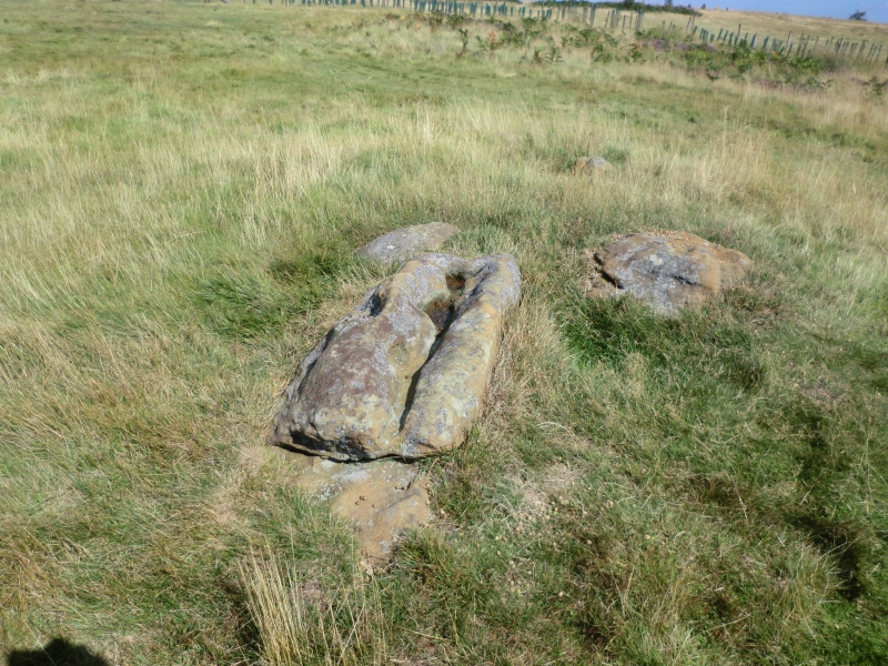
The barrow has a well defined earth and stone mound standing 0.5m high. It is
round in shape and is 10m in diameter. The mound was surrounded by a ditch up
to 3m wide which has been filled-in over the years and is no longer visible as
an earthwork. The centre of the mound has been dug into in the past. On the
top of the mound two large stones lie exposed. These are covered in grooves
and hollows, but these are considered to be the product of natural erosion
rather than artificial carvings.
It is one of many similar barrows on this area of the Hambleton Hills. Many of
these lie in closely associated groups, particularly along the watersheds.
They provide evidence of territorial organisation marking divisions of land,
divisions which still remain as some parish or township boundaries.
MAP EXTRACT
The site of the monument is shown on the attached map extract.
It includes a 2 metre boundary around the archaeological features,
considered to be essential for the monument's support and preservation.
Source: Historic England
Bowl barrows, the most numerous form of round barrow, are funerary monuments
dating from the Late Neolithic period to the Late Bronze Age, with most
examples belonging to the period 2400-1500 BC. They were constructed as
earthen or rubble mounds, sometimes ditched, which covered single or multiple
burials. They occur either in isolation or grouped as cemeteries and often
acted as a focus for burials in later periods. Often superficially similar,
although differing widely in size, they exhibit regional variations in form
and a diversity of burial practices. There are over 10,000 surviving bowl
barrows recorded nationally (many more have already been destroyed), occurring
across most of lowland Britain. Often occupying prominent locations, they are
a major historic element in the modern landscape and their considerable
variation of form and longevity as a monument type provide important
information on the diversity of beliefs and social organisations amongst early
prehistoric communities. They are particularly representative of their period
and a substantial proportion of surviving examples are considered worthy of
protection.
Despite limited disturbance this barrow has survived well. Significant
information about the original form, burials placed within it and evidence of
earlier land use beneath the mound will be preserved. Although in an isolated
position this monument is associated with a group of barrows on the edge of
the Hambleton Hills. Similar groups of monuments are also known across the
northern and central areas of the North York Moors providing important insight
into burial practice during the prehistoric period.
Source: Historic England
Books and journals
Spratt, D A , 'Prehistoric and Roman Archaeology in North East Yorkshire' in Prehistoric and Roman Archaeology of North East Yorkshire, , Vol. BAR 104, (1993), 116-120
Source: Historic England
Other nearby scheduled monuments