Approximate Location Map
Large Map »
This site is entirely user-supported. See how you can help.
If Google Street View is available, the image is from the best available vantage point looking, if possible, towards the location of the monument. Where it is not available, the satellite view is shown instead.
Latitude: 54.2842 / 54°17'3"N
Longitude: -0.8737 / 0°52'25"W
OS Eastings: 473424.57064
OS Northings: 488201.464857
OS Grid: SE734882
Mapcode National: GBR QLBX.N0
Mapcode Global: WHF9N.KL51
Entry Name: Low Cross, a reused standing stone on Kirkgate Lane in Appleton-le-Moors
Scheduled Date: 19 October 1995
Source: Historic England
Source ID: 1012888
English Heritage Legacy ID: 25637
County: North Yorkshire
Civil Parish: Appleton-le-Moors
Traditional County: Yorkshire
Lieutenancy Area (Ceremonial County): North Yorkshire
The monument includes a standing stone known as Low Cross on the junction of
Kirkgate Lane and Hamley Lane in the village of Appleton-le-Moors.
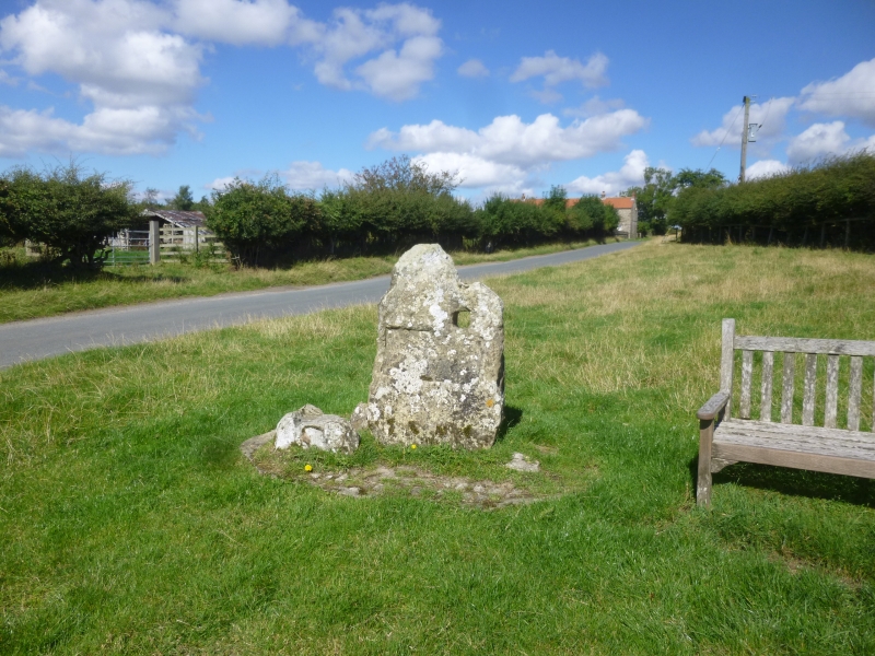
The monument consists of a slab of eroded limestone set upright on a modern
cobbled plinth 3m from the road edge and on a wide verge. Set into the cobbles
around the slab are six boulders in a cluster.
The slab stands 1.27m high and is 0.81m wide at the base and 0.32m thick on
average. The south face has a rectangular indentation cut halfway up the slab
as if to take a plaque. Under the shoulder of this face and on the east side
is a square hole cut through the stone 0.11m wide.
The boulders suggest that broken pieces of the original monument have been
preserved here. The broken pieces vary in size from 0.54m to 0.18m wide.
The name Low Cross given to this monument and its association with High Cross
to the north suggest that the stone has been given a Christian identity as a
wayside marker to identify the road to Lastingham in the medieval period.
Standing stones are frequently adopted in this way and found in graveyards and
other contexts in Britain. The hole and the cut for a plaque are more recent
and may have been for a toll bar at this point.
The stone, the boulders and the modern plinth are included in the scheduling.
MAP EXTRACT
The site of the monument is shown on the attached map extract.
It includes a 2 metre boundary around the archaeological features,
considered to be essential for the monument's support and preservation.
Source: Historic England
Standing stones are prehistoric ritual or ceremonial monuments with dates
ranging from the Late Neolithic to the end of the Bronze Age for the few
excavated examples. They comprise single or paired upright orthostatic slabs,
ranging from under lm to over 6m high where still erect. They are often
conspicuously sited and close to other contemporary monument classes. They can
be accompanied by various features: many occur in or on the edge of round
barrows, and where excavated, associated subsurface features have included
stone cists, stone settings, and various pits and hollows filled in with earth
containing human bone, cremations, charcoal, flints, pots and pot sherds.
Similar deposits have been found in excavated sockets for standing stones,
which range considerably in depth. Several standing stones also bear cup and
ring marks. Standing stones may have functioned as markers for routeways,
territories, graves, or meeting points, but their accompanying features show
they also bore a ritual function and that they form one of several ritual
monument classes of their period that often contain a deposit of cremation and
domestic debris as an integral component. No national survey of standing
stones has been undertaken, and estimates range from 50 to 250 extant
examples, widely distributed throughout England but with concentrations in
Cornwall, the North Yorkshire Moors, Cumbria, Derbyshire and the Cotswolds.
Standing stones are important as nationally rare monuments, with a high
longevity and demonstrating the diversity of ritual practices in the Late
Neolithic and Bronze Age. Consequently all undisturbed standing stones and
those which represent the main range of types and locations would normally be
considered to be of national importance.
This standing stone has been reused as a wayside cross. Wayside crosses were
erected during the medieval period and served the function of reiterating the
Christian faith to those who passed the cross and of reassuring the
traveller. They also served as waymarkers. In this instance the cross marked
a well travelled route linking important settlements for such functions as
funeral processions.
Wayside crosses contribute significantly to our understanding of medieval
religious customs and of medieval routeways and settlement patterns. All those
crosses which survive as earthfast monuments, except those which are badly
damaged and removed from their original locations, are considered worthy of
protection.
The stone known as Low Cross is associated with High Cross in medieval
documents. Although there is no trace of a cross head or Christian carving on
the stone, the location is original and its use as a wayside cross is
undisputed.
Source: Historic England
Books and journals
Hayes, R H, Old Roads and Pannierways in North East Yorkshire, (1988), 56
Source: Historic England
Other nearby scheduled monuments