Approximate Location Map
Large Map »
This site is entirely user-supported. See how you can help.
If Google Street View is available, the image is from the best available vantage point looking, if possible, towards the location of the monument. Where it is not available, the satellite view is shown instead.
Latitude: 54.4663 / 54°27'58"N
Longitude: -0.7036 / 0°42'12"W
OS Eastings: 484124.575438
OS Northings: 508648.631686
OS Grid: NZ841086
Mapcode National: GBR RJJS.GR
Mapcode Global: WHG9X.5Z7Z
Entry Name: Wayside cross known as Swarth Howe Cross, 500m north east of Moorcock
Scheduled Date: 28 February 1995
Source: Historic England
Source ID: 1009849
English Heritage Legacy ID: 25644
County: North Yorkshire
Civil Parish: Egton
Traditional County: Yorkshire
Lieutenancy Area (Ceremonial County): North Yorkshire
Church of England Parish: Egton St Hilda
Church of England Diocese: York
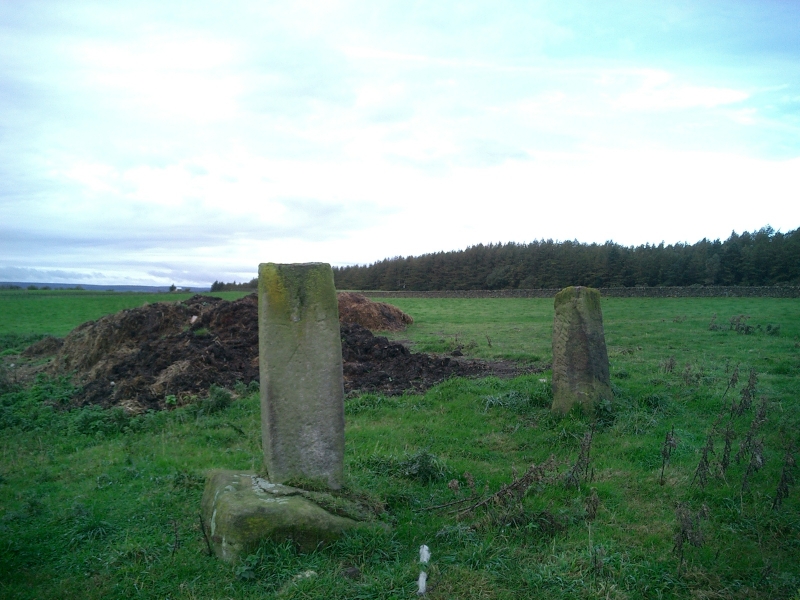
The monument includes a wayside cross known as Swarth Howe Cross, situated 30m
south of the A171 and 500m north east of Moorcock. The cross also serves as a
boundary marker for the parish of Aislaby.
The Swarth Howe Cross survives as a massive stone base of coarse yellow
sandstone 1.1m wide and 0.97m deep, crumbling away on the north side. The base
is 0.72m high and rests on a low pile of stones set into the turf. The shaft
is not original but a roughly squared block of sandstone set into the base
socket at an angle and fixed in place with concrete. The angle compensates for
the way the base has tipped back towards the south and brings the shaft
upright. The shaft is 0.47m wide and 0.38m deep with the wide faces to the
north and south. It is 1.27m high.
On the south face are the carved letters GR for Guisborough; on the east face
A for Aislaby; on the west face is the letter I and the dates of the boundary
perambulations 1752, 1774, 1799, 1821, 1841 and 1858. On the north face is
written `Egton Road'. In the top of the shaft a hole has been drilled 0.04m
wide and 0.11m deep as if to take a peg of steel and a further section of a
shaft which is now missing. On the north face there are two holes for a gate
fastening.
The cross marks a hollow way or old track from Egton, over Kempstone Rigg,
towards Hutton Mulgrave. The shaft has replaced an Anglo-Saxon carved cross
shaft now lost. It was in place when the parish system was laid out and was
used to mark a boundary for the parish of Aislaby. The later shaft confirms
both the functions of the original as waymarker and as boundary cross. We must
conclude that the cross, which is Listed Grade II, is in its original
position.
The gatepost on the north side of the monument is excluded from the scheduling
but the ground beneath it is included.
MAP EXTRACT
The site of the monument is shown on the attached map extract.
It includes a 2 metre boundary around the archaeological features,
considered to be essential for the monument's support and preservation.
Source: Historic England
Wayside crosses are one of several types of Christian cross erected during the
medieval period, mostly from the 9th to 15th centuries AD. In addition to
serving the function of reiterating and reinforcing the Christian faith
amongst those who passed the cross and of reassuring the traveller, wayside
crosses often fulfilled a role as waymarkers, especially in difficult and
otherwise unmarked terrain. The crosses might be on regularly used routes
linking ordinary settlements or on routes having a more specifically religious
function, including those providing access to religious sites for parishioners
and funeral processions, or marking long-distance routes frequented on
pilgrimages.
Over 350 wayside crosses are known nationally, concentrated in south west
England throughout Cornwall and on Dartmoor where they form the commonest type
of stone cross. A small group also occurs on the North York Moors. Relatively
few examples have been recorded elsewhere and these are generally confined to
remote moorland locations.
Outside Cornwall almost all wayside crosses take the form of a `Latin' cross,
in which the cross-head itself is shaped within the projecting arms of an
unenclosed cross. In Cornwall wayside crosses vary considerably in form and
decoration. The commonest type includes a round, or `wheel', head on the faces
of which various forms of cross or related designs were carved in relief or
incised, the spaces between the cross arms possibly pierced. The design was
sometimes supplemented with a relief figure of Christ and the shaft might bear
decorative panels and motifs. Less common forms in Cornwall include the
`Latin' cross and, much rarer, the simple slab with a low relief cross on both
faces. Rare examples of wheel-head and slab-form crosses also occur within the
North York Moors group. Most wayside crosses have either a simple socketed
base or show no evidence for a separate base at all.
Wayside crosses contribute significantly to our understanding of medieval
religious customs and sculptural traditions and to our knowledge of medieval
routeways and settlement patterns. All wayside crosses which survive as earth-
fast monuments, except those which are extremely damaged and removed from
their original locations, are considered worthy of protection.
Swarth Howe Cross survives well as a base for an important Anglo-Saxon wayside
cross and later boundary marker. Despite the loss of its original shaft the
new shaft is of considerable interest as a record of the 18th century
perambulations and as a waymarker among a series of such monuments on the
upland routes of the North York Moors.
Source: Historic England
Books and journals
Hayes, R H, Old Roads and Pannierways in North East Yorkshire, (1988), 23
Young, G, History of Whitby, (1817), 754
Source: Historic England
Other nearby scheduled monuments