Approximate Location Map
Large Map »
This site is entirely user-supported. See how you can help.
If Google Street View is available, the image is from the best available vantage point looking, if possible, towards the location of the monument. Where it is not available, the satellite view is shown instead.
Latitude: 54.3257 / 54°19'32"N
Longitude: -1.0986 / 1°5'54"W
OS Eastings: 458724.429713
OS Northings: 492614.058575
OS Grid: SE587926
Mapcode National: GBR NLRF.Y3
Mapcode Global: WHF9C.3J4P
Entry Name: Roppa South Cross on Carr Cote Ridge 1100m WSW of Piethorn
Scheduled Date: 6 January 1995
Source: Historic England
Source ID: 1011746
English Heritage Legacy ID: 25685
County: North Yorkshire
Civil Parish: Helmsley
Traditional County: Yorkshire
Lieutenancy Area (Ceremonial County): North Yorkshire
Church of England Parish: Helmsley All Saints
Church of England Diocese: York
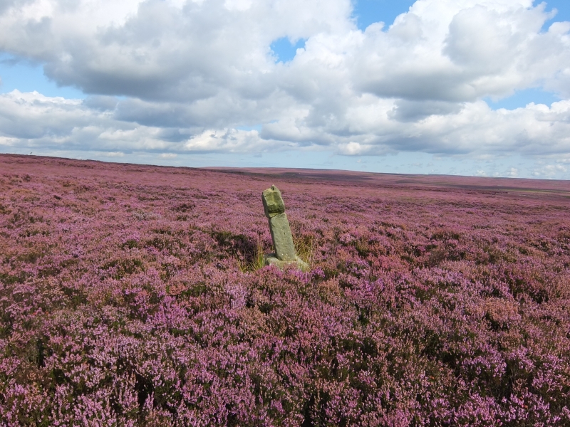
The monument comprises a cross base, cross shaft and cross head with a
fragment of the original cross shaft set up beside it. It stands on open
managed moorland 1100m WSW of the farm called Piethorn on the Carr Cote Ridge
on Helmsley Moor.
The cross is made from local fine gritstone. The base measures 0.63m by 0.6m
at the ground and tapers to 0.5m by 0.48m. The base stands 0.47m high. The
socket is 0.31m by 0.22m. In the socket is the broken shaft whose deep
rippling may be the remains of a sculptured interlace design. The shaft
measures 0.25m by 0.22m wide and 0.55m high. Above the shaft, fixed with
cement is a fragmentary cross head, originally rounded, with a Maltese cross
incised on the west face. Beside the cross on the south side, is a further
piece of the shaft set up in the turf. This measures 0.27m by 0.22m and
stands 0.57m high. This has a cross incised on the top surface. Such crosses
appear to be the location marks of an estate boundary.
Both standing structures should be considered as parts of the same monument.
MAP EXTRACT
The site of the monument is shown on the attached map extract.
It includes a 2 metre boundary around the archaeological features,
considered to be essential for the monument's support and preservation.
Source: Historic England
Wayside crosses are one of several types of Christian cross erected during the
medieval period, mostly from the 9th to 15th centuries AD. In addition to
serving the function of reiterating and reinforcing the Christian faith
amongst those who passed the cross and of reassuring the traveller, wayside
crosses often fulfilled a role as waymarkers, especially in difficult and
otherwise unmarked terrain. The crosses might be on regularly used routes
linking ordinary settlements or on routes having a more specifically religious
function, including those providing access to religious sites for parishioners
and funeral processions, or marking long-distance routes frequented on
pilgrimages.
Over 350 wayside crosses are known nationally, concentrated in south west
England throughout Cornwall and on Dartmoor where they form the commonest type
of stone cross. A small group also occurs on the North York Moors. Relatively
few examples have been recorded elsewhere and these are generally confined to
remote moorland locations.
Outside Cornwall almost all wayside crosses take the form of a `Latin' cross,
in which the cross-head itself is shaped within the projecting arms of an
unenclosed cross. In Cornwall wayside crosses vary considerably in form and
decoration. The commonest type includes a round, or `wheel', head on the faces
of which various forms of cross or related designs were carved in relief or
incised, the spaces between the cross arms possibly pierced. The design was
sometimes supplemented with a relief figure of Christ and the shaft might bear
decorative panels and motifs. Less common forms in Cornwall include the
`Latin' cross and, much rarer, the simple slab with a low relief cross on both
faces. Rare examples of wheel-head and slab-form crosses also occur within the
North York Moors group. Most wayside crosses have either a simple socketed
base or show no evidence for a separate base at all.
Wayside crosses contribute significantly to our understanding of medieval
religious customs and sculptural traditions and to our knowledge of medieval
routeways and settlement patterns. All wayside crosses which survive as earth-
fast monuments, except those which are extremely damaged and removed from
their original locations, are considered worthy of protection.
The cross known as the Roppa South Cross on Helmsley Moor survives well in
spite of the evidence of a broken shaft and battered head. It is in its
original position at the side of an important medieval trackway from Helmsley
to Bilsdale.
Source: Historic England
Books and journals
Hayes, R H, Old Roads and Pannierways in North East Yorkshire, (1988), 43
Source: Historic England
Other nearby scheduled monuments