Approximate Location Map
Large Map »
This site is entirely user-supported. See how you can help.
If Google Street View is available, the image is from the best available vantage point looking, if possible, towards the location of the monument. Where it is not available, the satellite view is shown instead.
Latitude: 50.1164 / 50°6'59"N
Longitude: -5.5706 / 5°34'14"W
OS Eastings: 144841.6962
OS Northings: 30143.028606
OS Grid: SW448301
Mapcode National: GBR DXMC.P56
Mapcode Global: VH05H.DBDL
Entry Name: Tremethick Cross, 760m east of Tremethick Farm
Scheduled Date: 19 May 1952
Last Amended: 18 January 1995
Source: Historic England
Source ID: 1010844
English Heritage Legacy ID: 26240
County: Cornwall
Civil Parish: Madron
Traditional County: Cornwall
Lieutenancy Area (Ceremonial County): Cornwall
Church of England Parish: Madron
Church of England Diocese: Truro
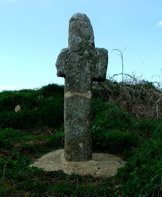
The monument includes a medieval wayside cross, known as the Tremethick Cross,
the mound on which it is now sited and a protective margin around it, situated
at a fork in the main route west across the Penwith peninsula from Newlyn and
Penzance to St Just in west Cornwall.
The Tremethick Cross survives as an upright head and shaft. The cross-head has
unenclosed arms, a form called a `Latin' cross, its principal faces orientated
to face east and west. The cross stands 1.61m high. The head measures 0.5m
across its side arms. Each arm is 0.33m wide; the intact north arm is 0.32m
long, the south arm is fractured, surviving to 0.07m long. The upper limb is
0.33m high, tapering asymmetrically to a rounded end. The shaft measures 0.25m
wide and 0.36m thick, tapering to 0.32m thick below the side arms. The cross
is situated on top of an artificial earthen mound with no visible base stone,
however the historian Langdon noted an overgrown base slab on the mound in
1896. The mound supporting the cross measures 9m north-south by 7m east-west
and rises 0.75m high. Langdon records a local tradition that this mound was a
prehistoric funerary barrow.
The monument is located in the western angle of a fork in the main route west
from Penzance to Newlyn across the Penwith peninsula to St Just. In 1872, the
historian Blight recorded that the cross had been moved to its present
location from Rose-an-Beagle, 3km to the south in Paul parish.
The metalled surface of the roads passing to the north and south of the mound
but within the area of the protective margin is excluded from the scheduling
but the ground beneath is included.
MAP EXTRACT
The site of the monument is shown on the attached map extract.
It includes a 2 metre boundary around the archaeological features,
considered to be essential for the monument's support and preservation.
Source: Historic England
Wayside crosses are one of several types of Christian cross erected during the
medieval period, mostly from the 9th to 15th centuries AD. In addition to
serving the function of reiterating and reinforcing the Christian faith
amongst those who passed the cross and of reassuring the traveller, wayside
crosses often fulfilled a role as waymarkers, especially in difficult and
otherwise unmarked terrain. The crosses might be on regularly used routes
linking ordinary settlements or on routes having a more specifically religious
function, including those providing access to religious sites for parishioners
and funeral processions, or marking long-distance routes frequented on
pilgrimages.
Over 350 wayside crosses are known nationally, concentrated in south west
England throughout Cornwall and on Dartmoor where they form the commonest type
of stone cross. A small group also occurs on the North York Moors. Relatively
few examples have been recorded elsewhere and these are generally confined to
remote moorland locations.
Outside Cornwall almost all wayside crosses take the form of a `Latin' cross,
in which the cross-head itself is shaped within the projecting arms of an
unenclosed cross. In Cornwall wayside crosses vary considerably in form and
decoration. The commonest type includes a round, or `wheel', head on the faces
of which various forms of cross or related designs were carved in relief or
incised, the spaces between the cross arms possibly pierced. The design was
sometimes supplemented with a relief figure of Christ and the shaft might bear
decorative panels and motifs. Less common forms in Cornwall include the
`Latin' cross and, much rarer, the simple slab with a low relief cross on both
faces. Rare examples of wheel-head and slab-form crosses also occur within the
North York Moors group. Most wayside crosses have either a simple socketed
base or show no evidence for a separate base at all.
Wayside crosses contribute significantly to our understanding of medieval
religious customs and sculptural traditions and to our knowledge of medieval
routeways and settlement patterns. All wayside crosses which survive as earth-
fast monuments, except those which are extremely damaged and removed from
their original locations, are considered worthy of protection.
The Tremethick Cross has survived well as a good example of the rather
uncommon `Latin' cross type. Although it has been moved from its original
location, its present position as a waymarker on an major route across the
Penwith peninsula illustrates the major role of wayside crosses; its post-
medieval re-erection here demonstrates a revival of the tradition of erecting
crosses at junctions, showing one aspect in the changing religious sentiments
since the Reformation.
Source: Historic England
Books and journals
Langdon, A G, Old Cornish Crosses, (1896)
Other
Title: 1:25000 Ordnance Survey Map; SW 33/43/part 53; Pathfinder 1364
Source Date: 1989
Author:
Publisher:
Surveyor:
Source: Historic England
Other nearby scheduled monuments