Approximate Location Map
Large Map »
This site is entirely user-supported. See how you can help.
If Google Street View is available, the image is from the best available vantage point looking, if possible, towards the location of the monument. Where it is not available, the satellite view is shown instead.
Latitude: 54.1091 / 54°6'32"N
Longitude: -1.5813 / 1°34'52"W
OS Eastings: 427472.968307
OS Northings: 468220.658291
OS Grid: SE274682
Mapcode National: GBR KNDX.GR
Mapcode Global: WHC7T.PZ67
Entry Name: Fountains Cistercian Abbey; monastic precinct, mill, water management works, agricultural and industrial features and 18th century gardens
Scheduled Date: 8 February 1915
Last Amended: 13 May 1996
Source: Historic England
Source ID: 1014395
English Heritage Legacy ID: 26930
County: North Yorkshire
Civil Parish: Lindrick with Studley Royal and Fountains
Traditional County: Yorkshire
Lieutenancy Area (Ceremonial County): North Yorkshire
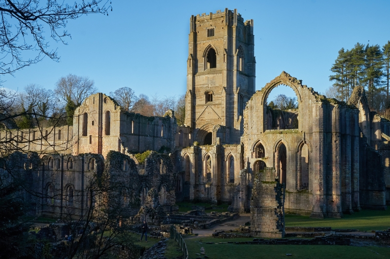
Fountains Abbey is situated south west of Ripon, lying in a narrow valley of
the River Skell, the north side of which has been quarried to form a cliff.
The monument comprises a single area containing the standing remains of the
monastery, and associated features lying within the outer precinct wall. Also
included are elements of the 18th century gardens of Fountains Hall.
Lying to the north of, and occasionally straddling the river itself, the
extensive and exceptionally well preserved standing remains demonstrate the
usual layout of a Cistercian monastery, with an east to west orientated church
forming the north range of a four-sided complex known as the cloister, the
remaining sides containing accommodation for lay and monastic brethren, and
domestic and administrative functions. Further buildings lie to the east and
west of the main claustral complex. The remains of timber buildings and of the
first stone church built in the 1130s and 1140s respectively have been
revealed in excavations within the existing standing remains and it is thought
that similar traces will be preserved elsewhere. The main body of the existing
church, nave, aisles and transepts, dates primarily to the 1150s and 1160s
when an earlier church, partly damaged by fire, was replaced by a much larger
structure. The grand scale of its design and plan are typical of mid 12th
century Cistercian building in Europe, and the order's austerity is shown in
the nave by the lack of a triforium or gallery. In the crossing, where the
transepts meet the nave, is a set of stone lined pits known as resonance
chambers which served to amplify the sound of the offices being sung in the
choir stalls set above. The mid 12th century presbytery, at the east end of
the church, was aisleless and square ended and, along with the inner transept
chapels, was demolished in the early 13th century to be replaced by the larger
aisled presbytery and further transept which stands today. This second
transept known as the Chapel of Nine Altars stands to almost its original
height and much of the original architectural detailing is preserved. To the
north of the main transept Huby's tower also stands to its original height of
48.7m. Built in the early 16th century, it survives intact but for its floors,
roof, bells and some window tracery. The cloister and claustral ranges to the
south of the church were originally laid out in the 1140s and were further
modified and enlarged in two phases of rebuilding, between the 1160s and the
1180s. The east range has on its ground floor the library, the chapter house,
the parlour, and a long room used for manual work projecting beyond the
cloister. The whole of the first floor was originally occupied by the monks'
dormitory. The south range has the monks' refectory at its centre, with the
warming house on its east side and the kitchens, which also served the lay
brothers' refectory, to the west. The refectory itself is one of the noblest
rooms in the abbey, retaining many of the original features that define its
use. The west range is 91.5m long and the southern end is carried over the
river on the footings of an earlier bridge. The ground floor, which housed the
cellarium or storehouse and the lay brothers' refectory, survives completely.
It is vaulted in 22 double bays from a line of central piers from which the
ribs spring without an intervening capital, and although now a single open
space, it was originally subdivided into separate rooms. Above this the lay
brothers' dormitory was located. The chapter house and the north part of the
west range were built in the 1160s and the south part of the west range, the
south range and the cloister arcade were constructed in the 1170s, and
throughout the existing ruins remains of the earlier structures can be clearly
identified. The rebuilding of the 1150s to 1170s also saw the expansion of the
abbey complex to the west with the construction of the guest houses, which
still stand to the first floor level, and the abbot's lodgings to the south
east. The lay brothers' infirmary standing astride the river also dates from
this time. Further to the east of the abbot's lodgings lie the remains of the
monks' infirmary, a large complex of structures straddling the river over
seven vaulted tunnels dating to the early 13th century building phase of the
abbey. In common with monastic tradition the precinct falls into two distinct
areas, the inner court where religious and administrative activities took
place and the outer court which was given over to agricultural and industrial
processes. The inner court is defined by the River Skell to the south and the
quarried cliff face to the north. To the west a wall and large gatehouse close
the neck of land between the Skell and the cliff. Built in the 1170s, the
gatehouse had two vaulted halls, a porch and a porter's lodge, of which the
south and north walls of the hall remain visible.
In the outer court are features associated with the day to day economic and
industrial activity of the abbey. Most prominent of these is the corn mill
dating mostly to the early 13th century, with elements of earlier buildings
incorporated within it. This building still stands and was in use as a working
mill until 1937, powered by a leat fed from the River Skell. To the east lie
the remains of the woolhouse and the malthouse; both structures only stand to
their lower courses. There is a complex water management system running
east to west through the site. The River Skell was rerouted in the 1140s to
run 28m further to the south along stone revetted and lined channels
to form the edge of the inner precinct, whilst a stone drain was constructed
along its old line to flush latrines that were built above. A further channel
fed water from a weir and sluice to the west of the outer precinct to provide
motive power to the corn mill before rejoining the main channel. The woolhouse
and malt house were fed by a ghyll running down Kitchen Bank to the east. The
river continues under bridges, and through channels and tunnels, beneath the
west claustral range and both the infirmaries, where it flushed latrines and
aided sanitation in the buildings above. The river continues to be channelled
to the east, across two weirs and becomes part of the formal gardens of
Studley Royal. Water was provided to the abbey itself through a system of
pipes leading from wells. One such well, known as Robin Hood's Well, lies to
the east of the infirmary and dates to the 1160s. The wellhead has an ornate
18th century cover and is fed from a reservoir on the slope above. On the
slope to the south of the river are the earthwork remains of 21 buildings with
yards and linking roads. They are concentrated along the banks of a ghyll
running north to south, fed in part by a reservoir at the top of the hill and
culminating at the woolhouse at the bottom. They are believed to be the
remains of buildings associated with the ancillary industrial and agricultural
activities of the abbey such as workshops and stores. However the full extent
and nature of these earthworks is not yet fully understood. Surrounding most
of the site, the outer precinct wall still stands to much of its original
height for most of its length. Dating to the early 13th century, it survives
up to 3.4m high to the top of its coping and originally enclosed an area of
37.2 ha. It is well preserved on the west and south sides, whilst to the east
only the lower courses remain. In the north west the wall extends eastwards
from the West Gate to join the inner gatehouse. After the dissolution the
inner precinct became part of the gardens firstly of Fountains Hall and
secondly within the formal planned gardens of Studley Royal, where the abbey
was considered as a romantic ruin. There is a walled garden to the south and a
series of terraces to the east and north of Fountains Hall, whilst at the east
end of the area is the site of a rustic lodge which forms part of the Studley
Royal gardens.
The abbey was founded in 1132 by a party of monks from the Benedictine Abbey
of St Mary in York and was adopted by the Cistercian order the following
year. It was intended as a Cistercian mission centre from which colonies were
sent out to found daughter houses throughout the North and Scotland. The early
years were hard, the abbey grew considerably but under Abbot Murdac in the
1140s the abbey was transformed and the replacement of an informal layout of
simple timber buildings by the formal enclosure of the cloister reflected
reform and the changes in philosophy within the Cistercian order. A
disastrous fire which ravaged the abbey in 1146, occasioned a phase of
rebuilding which replaced much of Murdac's recent work. Further developments
under abbots Murdac, Pipewell and Huby, saw the abbey increase in size and
grandeur to become the most powerful house in England. The abbey was finally
suppressed in 1539, when like most monastic houses it was stripped of all
fittings and partly quarried. The site passed first to the Gresham family
and then to the Procters who built Fountains Hall partly from material
quarried from the abbey. The abbey passed through several hands until it was
acquired by the Aislabie family from the adjacent Studley Royal Estate when it
became a feature within the formal landscaped gardens. Parts of the east end
of the site were cleared and altered to provide a more pleasing aspect of the
site as viewed from the east. A series of excavations and surveys have taken
place at Fountains from the early 19th century, and continue to this day. The
abbey was sold to the County Council in 1966 who in turn sold it to the
National Trust in 1983. The abbey has been in the care of the Secretary of
State since 1966.
The abbey is a Grade I Listed Building. Several other buildings with Listed
Building status lie within the area of the scheduling. These include Fountains
Hall and the mill, which are Listed Grade I. The steps and terracing to the
north and the gate piers and flanking walls of the Hall; the weir 10m east of
the infirmary; Robin Hood's well and the weir 120m west of the reservoir are
all Listed Grade II.
Several features within the protected area are excluded from the scheduling.
These include Fountains Hall, as defined by the exterior face of masonry, and
its garden to a depth of 300mm, the West Lodge, Deer Cottage, the museum and
works buildings in Mill Yard, farm buildings at Seven Sisters, farm buildings
and the surrounding yard surfaces against the precinct wall by Skell View
Cottages, and the surfaces of all public and modern estate roads and paths,
signs and fences although the ground beneath all these features is included.
MAP EXTRACT
The site of the monument is shown on the attached map extract.
It includes a 2 metre boundary around the archaeological features,
considered to be essential for the monument's support and preservation.
Source: Historic England
From the time of St Augustine's mission to re-establish Christianity in AD 597
to the reign of Henry VIII, monasticism formed an important facet of both
religious and secular life in the British Isles. Settlements of religious
communities, including monasteries, were built to house communities of monks,
canons (priests), and sometimes lay-brothers, living a common life of
religious observance under some form of systematic discipline. It is estimated
from documentary evidence that over 700 monasteries were founded in England.
These ranged in size from major communities with several hundred members to
tiny establishments with a handful of brethren. They belonged to a wide
variety of different religious orders, each with its own philosophy. As a
result, they vary considerably in the detail of their appearance and layout,
although all possess the basic elements of church, domestic accommodation for
the community, and work buildings. Monasteries were inextricably woven into
the fabric of medieval society, acting not only as centres of worship,
learning and charity, but also, because of the vast landholdings of some
orders, as centres of immense wealth and political influence. They were
established in all parts of England, some in towns and others in the remotest
of areas. Many monasteries acted as the foci of wide networks including parish
churches, almshouses, hospitals, farming estates and tenant villages. Some 75
of these religious houses belonged to the Cistercian order founded by St
Bernard of Clairvaux in the 12th century. The Cistercians - or "white monks",
on account of their undyed habits - led a harsher life than earlier monastic
orders, believing in the virtue of a life of austerity, prayer and manual
labour. Seeking seclusion, they founded their houses in wild and remote areas
where they undertook major land improvement projects. Their communities were
often very large and included many lay brethren who acted as ploughmen,
dairymen, shepherds, carpenters and masons. The Cistercians' skills as farmers
eventually made the order one of the richest and most influential. They were
especially successful in the rural north of England where they concentrated on
sheep farming. The Cistercians made a major contribution to many facets of
medieval life and all of their monasteries which exhibit significant surviving
archaeological remains are worthy of protection.
Fountains became the most powerful and prosperous monastic house in the North
of England. The main monastic buildings survive remarkably well and retain
important architectural evidence of the changing wealth and status of the
community. In particular the Chapel of the Nine Altars, unique in England, is
preserved to its full height and the cellarium of the west range still retains
its vaulted roof for a length of 91.5m. The whole precinct layout of the abbey
and its ancillary buildings can be identified both as upstanding features and
buried remains. The extensive water management system demonstrates well the
importance of a sufficient supply to support domestic, agricultural and
industrial activities. The incorporation of the abbey into the formal gardens
of Studley Royal Estate provides important insights into 18th century
landscaping and the contemporary attitudes to the past. Together these various
features allow the development and workings of the whole precinct to be
studied and provide an important opportunity for detailed analysis of the
monastic economy. The exceptional state of preservation and variety of
features found within the site makes Fountains of particular importance to
European Cistercian studies.
Source: Historic England
Books and journals
Coppack, G, Abbeys and Priories, (1990), 81
Coppack, G, Abbeys and Priories, (1990)
Coppack, G, Fountains Abbey, (1993), 89-97
Coppack, G, Fountains Abbey, (1993)
Coppack, G, Abbeys and Priories, (1990), 115
Source: Historic England
Other nearby scheduled monuments