Approximate Location Map
Large Map »
This site is entirely user-supported. See how you can help.
If Google Street View is available, the image is from the best available vantage point looking, if possible, towards the location of the monument. Where it is not available, the satellite view is shown instead.
Latitude: 52.6273 / 52°37'38"N
Longitude: -2.4854 / 2°29'7"W
OS Eastings: 367239.785655
OS Northings: 303388.019181
OS Grid: SJ672033
Mapcode National: GBR BW.7GV7
Mapcode Global: WH9DG.S7N6
Entry Name: The Iron Bridge
Scheduled Date: 18 January 1934
Last Amended: 7 February 1997
Source: Historic England
Source ID: 1015325
English Heritage Legacy ID: 27558
County: Telford and Wrekin
Civil Parish: The Gorge
Built-Up Area: Telford
Traditional County: Shropshire
Lieutenancy Area (Ceremonial County): Shropshire
Church of England Parish: Broseley with Benthall and Jackfield
Church of England Diocese: Hereford
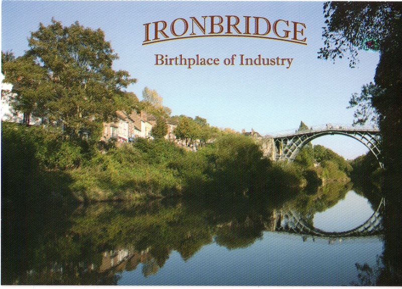
The monument includes the standing and buried remains of The Iron Bridge, an
18th century single span, cast iron bridge which links the steep sides of the
Ironbridge Gorge across the River Severn, and is now at the heart of the
settlement to which it gave its name.
The initial bridge design was drawn up by Thomas Pritchard, a Shrewsbury
architect, who had suggested to the ironmaster John Wilkinson in 1773 that an
iron bridge should be constructed across the river. In 1776 a petition to
parliament for a new bridge was successful, however iron had only been used
for strengthening timber or stone structures in the past, and it was several
months before the plan to construct the world's first completely cast iron
bridge was agreed. Work began in 1777, to a design evidently instigated by
Pritchard's original, although he himself had died earlier that year. The
chosen crossing point, previously the ferry crossing from Benthall to Madeley
Wood, had the advantage of high approaches on both sides and relative
stability, but its distance from existing turnpikes and the major ironworks
pushed up the total cost of construction to over 6000 pounds. Part of this
expense was borne by Abraham Darby himself, who remained in debt for the rest
of his life. The iron for the bridge was cast by the Coalbrookdale Company,
and construction was completed in 1779, using in all 300 tons of cast and
wrought iron. The bridge was originally carried between two huge rubble-
filled, ashlar faced, stone abutments. It had a wrought iron hand rail which
continued along the edges of the northern abutment, while a post and chain
rail ran along the sides of the southern abutment. However, episodes of
subsidence and flooding caused the southern abutment to crack, and it was
replaced in 1801 with two stone piers, with a wooden roadway and hand rail
between them. The wooden structure was in turn replaced in the 1820s by the
iron arches which stand today, and an iron hand rail replaced the wooden one.
On the north side the original parapet walls and footings were taken down in
1782 to accommodate one of the many buildings which were erected to either
side of the north abutment. Shortly after this the west wall was also removed,
probably as part of the construction of the Tontine stables close to the
bridge abutment. The Iron Bridge remained in full use for over 150 years, by
carts, stage coaches, and then increasing amounts of vehicular traffic.
Concerns about its stability in the 1920s nearly led to its replacement with a
concrete structure further upriver. In 1934 the bridge was designated an
Ancient Monument and closed to vehicular traffic. In the 1970s a concrete
strut was built on the river bed beneath the bridge, to brace the abutments
which had moved 0.48m towards each other by 1969, and this structure is
included in the scheduling. The Iron Bridge is now in the care of the
Secretary of State, is Listed Grade I, and is part of the Ironbridge World
Heritage Site designated in 1987.
The bridge is constructed of cold blast iron, and spans 100 feet 6 inches
(c.30m). The main structure is composed of five semicircular ribs, braced
laterally to each other, and by a filigree of connecting members to two
concentric inner part ribs. The two outer ribs are engraved with the words
`This Bridge was cast at Coalbrook-Dale and erected in the year MDCCLXXIX'.
The spandrels, between the curve of the arch and the abutments, contain iron
circles and an ogee shaped frame, both features of Thomas Pritchard's other
designs. The bridge has delicate wrought-iron hand rails with a central
ornamental roundel to either side, which early drawings indicate were
originally surmounted by single lamps. Early illustrations show that shops and
houses grew up around the northern abutment soon after the bridge was
completed, and after several phases of rebuilding these were finally
demolished in the 1950s. The frontage of some cellars has been retained on the
west side of the abutment, and the surrounding area has been landscaped with
flowerbeds and brick retaining walls. There are brick steps down to the river
on the east side, and modern parapets and railings edge a paved area extending
across the northern approach to the bridge. The side arch under the northern
abutment has a brick vault. Two side arches replaced the matching brick arch
on the south side; each has a single iron span with a semicircular arch braced
to concentric inner ribs, echoing the design of the main bridge span. The
supporting piers are of coursed sandstone blocks. A brick toll house, now an
information centre, sits on the west side of the south abutment. The original
structure is contemporary with the bridge, and was extended in the mid-19th
century. A metal gate extends between the toll house and a small brick
building on the east side, which was part of the original gate arrangement.
Modern steps lead down the east side of this building, against the southern
abutment, to the path along the river which passes under the southerly of the
two side arches.
All modern road and path surfaces, modern railings and fences, benches,
signposts and bollards, rubbish bins, modern retaining walls and steps, the
archways to the west of the northern abutment, modern drain pipes and
guttering, the cellar frontage at the north end of the bridge, and the gate,
toll house and brick building at the southern end of the bridge, are excluded
from the scheduling, although the ground beneath all these features is
included.
MAP EXTRACT
The site of the monument is shown on the attached map extract.
It includes a 5 metre boundary around the archaeological features,
considered to be essential for the monument's support and preservation.
Source: Historic England
Iron was used as one of the components of bridge construction for at least a
thousand years before it was first used as the principal construction material
in the Iron Bridge erected by Abraham Darby in 1779 over the Severn at
Coalbrookdale. Despite its use of iron, however, the Iron Bridge simply
copied existing construction techniques suited to timber, and therefore did
not make maximum use of the new material's potential. The engineer Thomas
Telford subsequently recognised that the lighter cast iron frames allowed the
use of flatter angles and less substantial foundations, whilst still enabling
single spans and avoiding the central piers which hindered navigation and
caused instability by attracting water-scouring.
The development of the single span cast iron bridge thus represented a turning
point in British bridge design and engineering. All examples which retain
significant original fabric are of national importance and will merit
statutory protection.
The Iron Bridge is a fine example of a class of monument which is rare
nationally, and is often seen as a symbol of the heyday of British bridge
design, if not of the Industrial Era itself. The standing structure of the
bridge increases our understanding of the casting and assembly methods
employed during this pioneering age. Archaeological deposits will survive
below ground relating to its construction, and to the modification of its
abutments over time. An extensive written and pictorial archive records the
conception, design, construction and modification of the bridge, as well as
its impact on the wider infrastructure and industrial development of the area.
This World Heritage Site is a prominent landmark, with easy public access.
Source: Historic England
Books and journals
De Haan, D, Abraham Darby's iron bridge of 1779: construction and restoration, (1992), 1-9
Other
photos, Bracegirdle, B and Miles, P H, Great engineers and their works: Thomas Telford, (1973)
photos, sections, Clark, C, Ironbridge Gorge, (1990)
photos, Smith, Stuart, A View from the Iron Bridge, (1979)
Source: Historic England
Other nearby scheduled monuments