Approximate Location Map
Large Map »
This site is entirely user-supported. See how you can help.
If Google Street View is available, the image is from the best available vantage point looking, if possible, towards the location of the monument. Where it is not available, the satellite view is shown instead.
Latitude: 51.9755 / 51°58'31"N
Longitude: -1.5709 / 1°34'15"W
OS Eastings: 429570.8222
OS Northings: 230867.8259
OS Grid: SP295308
Mapcode National: GBR 5R0.5NC
Mapcode Global: VHBZ1.QLDY
Entry Name: The Rollright Stones
Scheduled Date: 18 August 1882
Last Amended: 25 November 1999
Source: Historic England
Source ID: 1018400
English Heritage Legacy ID: 28160
County: Warwickshire
Civil Parish: Long Compton
Traditional County: Warwickshire
Lieutenancy Area (Ceremonial County): Warwickshire
Church of England Parish: Long Compton St Peter and St Paul
Church of England Diocese: Coventry
The monument includes a stone circle, portal dolmen, standing stone, round
cairn and a ditched round barrow which form the core of the megalithic sites
known collectively as the `Rollright Stones', situated 900m north east of
Little Rollright on the Oxfordshire - Warwickshire border and which lie within
three areas of protection. The monument was one of the 29 monuments protected
in the original Schedule for the 1882 Ancient Monuments Protection Act, and
was taken into state care in 1883. Although partly obscured by trees and
hedges today, the monuments may all originally have been inter-visible. The
Rollright Stones lie on the scarp of the Cotswolds on the crest of a ridge
running from south west to north east. They have attracted later activity
including burial mounds, an Iron Age settlement immediately to the north east
(which is the subject of a separate scheduling) and an Anglo-Saxon cemetery.
These, taken together, indicate that the area acted as a focus for ritual and
burial practice over a long period of time in a similar way to the more famous
landscapes around Stonehenge and Avebury in Wiltshire to the south west.
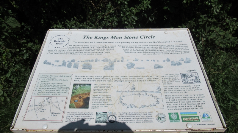
The most famous remains are the stone circle known as the `King's Men'
which forms the focus of the monument. The stone circle may once have
consisted of over 100 stones of which 70 are still standing today. The stones
are all local oolite limestone, erected in a tight circle giving the
impression of a continuous wall with a narrow entrance on the SSE side marked
by two portal stones. The circle has an internal diameter of approximately
32m, and the interior appears to have been free of stone structures. The
stones, along with the nearby King Stone, were surrounded in 1883 by a fence,
part of which still survives. The surviving original sections of the fence
around the stone circle and that around the King's Stone are included in the
scheduling.
A number of the stones have fallen over time whilst some of those now standing
were re-erected by the landowner and others in 1882. The circle is believed to
be the easternmost stone circle in England and is estimated to date to between
2500-2000 BC. Like many similar monuments, it has many folklore stories and
powers attributed to it, and part excavation in the mid-1980s indicated that a
slight bank was not contemporary but was of Roman or earlier date. This
suggests that the site was reused in some way by the inhabitants of the
settlement to the north during the Roman period.
A single oolite orthostat, known as `The King Stone' stands on a slight
natural rise 73m to the north east of the stone circle. This stone stands 2.4m
above ground and is 1.5m wide. A large semicircular notch on the eastern edge
of the stone is the result of people chipping off pieces of stone as souvenirs
over the past 200 years. The standing stone was erected, either as an outlier
on the approach to the stone circle to the south or as a marker for the
associated cemetery, represented by the cairn and barrow described below,
which have been dated to between 1880 and 1550 BC. Immediately north east of
the King Stone is a round cairn 17m in diameter constructed of quarried
limestone. Part excavation in 1982-3 showed that the cairn covers an unopened
burial cist or chamber of large limestone slabs with a cap stone in place. The
cairn was also the focus of secondary cremation burials, at least five of
which were located by the excavation. These were associated with pottery of
Bronze Age date. To the north east of this lies a small ditched round barrow
which is difficult to see at ground level, but which shows clearly as a
soil mark on aerial photographs and a geophysical survey plan. It was
upstanding in the early 1700s when visited by William Stukeley and may well
have been constructed mainly of stone rubble like the nearby cairn. The mound
measures approximately 13m in diameter and is surrounded by a quarry ditch
roughly 2m wide from which material would have been obtained during its
construction.
A free standing portal dolmen known as `The Whispering Knights' lies 357m east
of the stone circle, and consists of four large upright oolite orthostats with
a fallen capstone leaning at an angle to them. Together they enclose a chamber
roughly 2m square which would originally have had a stone rubble cairn. The
cairn is no longer present but part excavation in the 1980s found evidence for
it in the form of a rubble spread on the east side of the monument. The portal
dolmen is estimated to date to between 3800-3000 BC.
Excluded from the scheduling are all modern fence boundaries, the custodian's
hut and fixed notice boards, although the ground beneath these is included.
MAP EXTRACT
The site of the monument is shown on the attached map extract.
Source: Historic England
A small number of areas in southern England appear to have acted as foci for
ceremonial and ritual activity during the Neolithic and Early Bronze Age
periods. One of the best known and earliest recognised is the Rollright
Stones which were first mentioned in the Middle Ages and from the 17th century
have been the subject of much speculation and investigation. They were
designated as a nationally important monument on the first Schedule of Ancient
Monuments in 1882.
The monument clearly provided a focus for later activity including an Iron Age
settlement, an Anglo-Saxon cemetery and a number of other less well defined
remains spanning many periods.
Stone circles are prehistoric monuments comprising one or more circles of
upright or recumbent stones, often associated with funerary monuments such as
burial cairns and round barrows. Where excavated stone circles have been found
to date from the Late Neolithic to the Middle Bronze Age (c.2400-1000 BC). It
is clear that they were designed and laid out carefully. In many instances
excavation has indicated that they provided a focus for burials and the
rituals that accompanied interment of the dead.
Large irregular stone circles comprise a ring of at least 20 stone uprights.
The diameters of surviving examples vary between 20m and 40m, although it
is known that larger examples formerly existed. The stone uprights of this
type of circle tend to be more closely spaced than in other types of circle
and the height and positioning of uprights also appears not to have been so
important. They are widely distributed throughout England although in the
south they are confined mainly to the west. Of the 250 or so stone circles
identified in England only 45 examples of large irregular circles are known.
As a rare monument type which provides an important insight into prehistoric
ritual activity all surviving examples are worthy of preservation.
The Kings Men stone circle is one of the best preserved and most famous stone
circles in Britain. In addition, it is known from part excavation and non
destructive investigation to contain important archaeological evidence
relating to its construction, function and activities undertaken in and around
it. Furthermore, as the easternmost example of a type of site more generally
confined to the west it will provide important insights into the setting and
distribution of these monuments. Its design suggests affinity with similar
circles in the Lake District, eastern Ireland and Wales rather than with the
stone circles of Wessex.
The Whispering Knights portal dolmen is the easternmost example of its class
with the majority of similar monuments being located in Cornwall, Wales and
Ireland with only a small group in the east Cotswolds. It survives well and
despite the majority of its covering mound having been lost, it has been shown
from part excavation to contain archaeological remains relating to its
construction and the landscape in which it was built.
The King Stone is a good example of a standing stone which may have been
erected as a permanent marker of a sacred place - in this case a cemetery. The
stone and the nearby cairn and ditched round barrow, have all been shown to
contain archaeological remains relating to their own construction and use as
well as their relationship with each other.
In addition to being good examples of nationally rare monuments, the
inter-relationship of the monuments will provide the opportunity to study
their associations with each other and their place in the surrounding
landscape. The monuments are in the care of the Secretary of State, and are
opened to the public by the charitable trust which owns the site. They provide
an important educational amenity.
Source: Historic England
Books and journals
A History of the County of Oxfordshire: The Rollright Stones, (1937), 240
Burl, A, The Stone Circles of the British Isles, (1976)
Lambrick, G, The Rollright Stones, (1983)
Lambrick, G, Rollright Stones, (1988)
Ravenhill, T H, The Rollright Stones and the men who erected them, (1932)
Taunt, H W, The Rollright Stones, (1907)
Thomas, N, Guide to Prehistoric England, (1960), 168
Beesley, T, 'Transactions' in The Rollright Stones, , Vol. 1853-5, (1855), 61-74
Dryden, R H, 'Report' in The Dolmens at Rollright and Enstone, , Vol. 1897-8, (1898), 40-51
Evans, A J, 'Folklore' in The Rollright Stones and their Folklore, , Vol. Vol.vi, (1895), 6-51
Evans, A J, 'Transactions' in Rollright Stones, , Vol. Vol. 16, (1892), 38-40
Grinsell, L V, 'Folklore' in The Rollright Stones And Their Folklore, , Vol. 10, (1977)
Lambrick, G, 'Archaeological Reports' in The Rollright Stones: Megaliths, Monuments and Settlement in the, , Vol. 6, (1988)
Ravenhill, T H, 'Report' in The Rollright Stones, Some Facts And Some Problems, , Vol. 1926, (1926), 121-43
Ravenhill, T H, 'Transactions.' in Notes on the Rollright Stones, , Vol. Vol 51, (1928), 43-4
Rendall, V, 'Sat. Review' in A Glimpse of Neolithic England, the Rollright Stones, , Vol. vol 142, (1926), 307-8
Other
Humble, J, The Rollright Stones: management, condition and preservation, 1896, EH internal consultation paper
VARIOUS, Extracts from various authors relating to the Rollright Stones, (1884)
WA 2394, SMRO, The King Stone, (1995)
WA 2395, SMRO, Site of round barrow to north of King Stone, (1995)
WA 2398, SMRO, Site of Ring Ditch to NE of King Stone, (1995)
Source: Historic England
Other nearby scheduled monuments