Approximate Location Map
Large Map »
This site is entirely user-supported. See how you can help.
If Google Street View is available, the image is from the best available vantage point looking, if possible, towards the location of the monument. Where it is not available, the satellite view is shown instead.
Latitude: 51.1566 / 51°9'23"N
Longitude: -3.3634 / 3°21'48"W
OS Eastings: 304746.096872
OS Northings: 140588.032321
OS Grid: ST047405
Mapcode National: GBR LP.7FQ1
Mapcode Global: VH6GV.N676
Entry Name: Cleeve Abbey
Scheduled Date: 30 November 1925
Last Amended: 13 November 1996
Source: Historic England
Source ID: 1014824
English Heritage Legacy ID: 28519
County: Somerset
Civil Parish: Old Cleeve
Traditional County: Somerset
Lieutenancy Area (Ceremonial County): Somerset
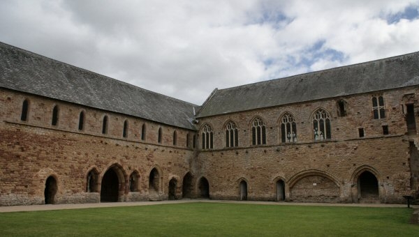
The monument includes a Cistercian abbey (Grade I Listed) with its inner
precinct and outer court on the east side of the River Washford. The precinct
and court are separated by a wall and gatehouse, much of which survives.
Contained within the precinct are a church, the claustral buildings,
fishponds, the base of a cross, earthworks representing internal boundaries
and water management features, and the site of Abbey Mill. The outer court
forms a rectangular enclave bounded on the north, south and west by walls
which still survive. Doorways in these walls led to orchards, meadows and
garths.
The cloister, at the centre of the abbey buildings, has a grassed rectangle at
its centre. The cloister was roofed over where it abutted the other abbey
buildings to provide a sheltered walkway. The remains of the roof of this
walkway or alley can be recognised on the walls of the ranges around the
cloister. Both the 13th century roofing and the 15th century rebuilding can be
seen. An important survival from the 13th century cloister is the shallow
recess, set midway along the south face of the wall of the south aisle of the
nave. This recess was intended as an architectural frame for the chair of the
abbot during the ceremonial reading known as the Collation. The greater part
of the lower storey of the west cloister alley remains intact, apart from the
southern part which was obscured during later rebuilding. The church stands on
the north side of the cloister, with the west end of the nave facing the outer
court. Its position can be seen in its lower courses only. It had a square
ended presbytery, transepts, each with two eastern chapels, and an aisled nave
of seven bays. In the centre of the nave is the stone coffin of an abbot. The
easternmost bay of the south aisle wall contained the processional doorway to
the cloister. The first floor doorway and the blocked ground floor doorway in
the westernmost bay of the aisle contain reused material and both are
insertions belonging to a cottage that was built here after the Dissolution.
The lower doorway occupies the site of a western processional doorway to the
cloister. The high floor level of the cottage explains the survival of a patch
of floor tiles in the westernmost bay of the aisle. The monks' quire occupied
the crossing and the easternmost bay of the nave, and the L-shaped foundations
for the quire stalls can be seen. The south wall of the south transept still
stands to the height of the adjoining dorter or dormitory, and originally
stood much higher. In its centre is a doorway leading to the sacristy at
ground floor level, and to the west of this at first floor level is another
doorway through which the night stairs from the church communicated with the
dorter. In the southernmost chapel there are fragments of the base of an altar
set against the east wall. The sacristy, adjoining the south transept of the
southernmost chapel, has a barrel roof. Some original features here include
twin lockers, slots for shelves and rebates for doors. At the east end of the
south wall is a piscina or stone basin for washing the chalice. Some of the
13th century hand painted decoration in this room can still be seen.
The library lies next to the sacristy on its south side. The 13th century
entrance to the library from the cloister was a large archway, later blocked,
and a smaller doorway preserved in the blocking. Internally, the room is
barrel vaulted, and the east wall has a single lancet window rebated for a
frame.
The next room to the south is the chapter house, which projects eastward from
the eastern side of the cloister. It is entered from the cloister by a large
doorway, on each side of which is a two-light window. The upper parts of the
walls and parts of the vault have the remains of plaster with some 13th
century painted decoration. The eastern bay of the chapter house is marked
only by its foundations, and just within this bay is a large stone slab with a
leaded socket to take the stem of the lectern.
To the south of the chapter house are the day stairs to the dorter and the
parlour. The parlour, entered via a 15th century doorway, has a barrel
vaulted roof and rectangular lockers on its south and west walls. The first
floor of the east range of buildings comprises the dorter or dormitory.
Between the parlour and the warming room to its south is the slype, a passage
which joins the cloister range of buildings to the infirmary range. On the
north wall of the slype are two sets of twin lockers, with a further set on
the south wall where there is also a doorway to the warming room. The warming
room or common room is three bays long and has had a modern groin vault
inserted. The north bay has a window in its east wall which was cut down to
floor level after the Dissolution to act as a doorway. On the corresponding
west wall is a blind recess. The central bay has the remains of a communal
fireplace on its east wall and the remains of an original window opposite it
on the west wall. The southernmost bay has three blocked doorways and three
windows.
Adjoining the warming room on its south east side is the basement plan of the
reredorter or latrine. It consists of a room measuring 17.25m east-west and
3.6m north-south, with a drain 1.3m wide on its south side above which the
garderobes would have been situated. The drain was diverted on this path after
the 15th century rebuilding of the south range. The warming room and the
reredorter formed the west and south sides of the infirmary cloister.
When first built during the second half of the 13th century the south range
conformed to the normal Cistercian plan. At its east end the day stairs
ascended to the dorter; next to them was the warming room; next to this the
refectory on a north-south axis in the centre of the range and extending
beyond it to the south; and at the west end was the kitchen. In the third
quarter of the 15th century the range was drastically remodelled to a new
plan.
The only 13th century features surviving are the northern doorway to the day
stairs still serving the passage that replaced them, a small doorway within
this passage serving the warming room, the lavatory near the refectory
doorway, the doorway itself, and the tiled pavement of the southern part of
the refectory with a doorway to the former kitchen.
The 15th century southern refectory range is of two storeys in its eastern
part and three storeys in its western part. The east end of the ground floor
is occupied by the passage with a 15th century doorway at its south end. The
remainder of the ground floor of the range is divided into two sets of two
chambers. The eastern set has a study or living room measuring 6.7m by 4.6m
with two windows in its south wall and between them a fireplace. At the south
end of the east wall of this room a doorway leads to a narrow bedchamber 6.7m
by 2.4m. It has a window in the south wall similar to those in the adjacent
study, but with splayed embrasure and window seat. Beside this is a doorway to
a garderobe. The western set of chambers has its own doorway from the
cloister, similar in appearance to the eastern set. It leads into a small
triangular lobby from which a doorway leads into the eastern set of chambers,
and an arch leads into the study of the western set. The western study is 0.3m
wider than the eastern one, but in all respects is similar. As originally
built, the bedchamber of the western set could only be reached by a doorway at
the south end of the west wall of the study, but is now accessible through
openings forced through the walls of the refectory staircase at the north end.
The original doorway leads into a lobby with a barrel-vaulted cellar beneath
the stairs at its north end. In the south wall of the lobby are a rectangular
window and a doorway to a garderobe.
The 15th century refectory which replaced the 13th century one was on the
first floor of the south range with its long axis east-west, contrary to
earlier Cistercian custom. The 13th century doorway was retained at ground
level and gives access to a flight of steps which end in a lobby at first
floor level. The purpose of the lobby was to accommodate people waiting for
admission to either the refectory or to the painted chamber on the west. The
painted chamber lies above the western bed chamber and has a window in its
south wall and a fireplace in its west wall. Some decorative painting can be
seen on the west wall, but the east wall is entirely covered by a late 15th
century wall painting. It is suggested that this room was a `checker' or
office serving the abbot's secretariat. The refectory itself is a hall 15.5m
by 6.7m. Its north wall has a row of five three-light windows and there are
four windows on the south wall. The second bay from the east on the south wall
has no window and housed a frater pulpit which has been largely destroyed by a
larger fireplace which was inserted in the 16th or 17th century. The
outstanding feature of the hall is its roof which is an excellent example of
medieval carpentry. At the north end of the west wall of the refectory a
doorway leads to a wooden gallery over the entrance to the refectory staircase
which continued along the north end of the painted chamber and into the west
range. There are the remains of a painting within the gallery depicting a
floral pattern and the head of a monk. Above the painted chamber there is
another chamber now reached by a new staircase in the room beyond the gallery.
Originally this upper chamber was accessed by stairs in a turret on the north
wall of the refectory range, but this is now destroyed. The upper chamber has
a window in its north and south walls and there is a fireplace on the west
wall; this wall also bears the traces of wall-painting. The chamber has a fine
late 15th century open timber roof.
The northern part of the west range of the claustral buildings was devoted to
the cellarer and the lay brethren. It is known from excavation to have been
6.7m wide and was built towards the end of the 13th century. Its north wall
partly survives, and part of the east wall survives to first floor height. The
full length of the range is not yet known, but it was at least 15.2m long
since it was curtailed here by the insertion of a cross wall in the later
Middle Ages. The south end of the west range consists of a group of rooms
which were part of the 18th century farmhouse accommodation. On the north side
of this group of rooms is the present day ticket office and shop. To the south
of this are two rooms, the western one of which was the 18th century farmhouse
kitchen; the eastern room has a late medieval fireplace. From this room four
steps lead down to the room at the south west corner of the claustral range.
Originally this room is thought to have been a monastic kitchen. It has a 13th
century arch in its north east corner and an altered fireplace on its west
wall. The room to the north of this, which was part of the monastic range, is
of irregular plan because of many post-Dissolution alterations. Above the room
thought to have been a monastic kitchen is a room which is a continuation of
the gallery joining the refectory to the west range. It is thought that by the
late Middle Ages the upper floor of the west range had become the abbot's
private apartments. The long room of the upper floor of the west range is
largely of post-Dissolution character.
The gatehouse stands in the south east corner of the courtyard and faces
north. It has two storeys and was built in the 13th century but altered in the
14th and remodelled in the 16th century. The ground floor forms the gate
passage, with a broad arch at either end. Above the outer, northern, arch is
the inscription in Latin `Gate be open, shut to no honest person'. Over the
inscription the first floor chamber has a window with four lights, and above
this the figure of the Virgin and Child. The passage was originally divided by
a cross-wall which had a large archway for wheeled vehicles and a doorway for
pedestrians. There are traces of the jambs of these arches, and the main gates
were hung at this point. The northern half of the passage served as a lobby
outside the gates for those waiting for access to the precinct. To the west of
the lobby was the almonry, and to the east the porter's lodge. Despite earlier
attempts to strengthen the gatehouse, early in the 16th century Abbot Dovell
found it necessary to add buttresses to all except the west wall and to
rebuild the upper storey completely. The upper storey has lost its floor, but
in addition to the four light window in each gable, it had a two light window
in its east wall, a doorway at the north end of the west wall, and a fireplace
near the centre. On the east side at the north end is evidence of a garderobe.
This upper storey of the gatehouse is thought to have been used for
administrative purposes, and to have been the abbey's court room. Most of the
existing walls on the site of the almonry, the blocked doorways in the east
and west walls of the upper chamber of the gatehouse and the traces of gabled
roofs abutting on its outside walls belong to its post-Dissolution use as a
farm building. The southern archway of the gate passage bears the inscription
`Dovell'. This end of the first floor chamber again has a four light window,
above which is a canopied Crucifixion.
Between the gatehouse and the abbey, c.7m to the west of the west range of the
conventual buildings, is a mound c.4m in diameter and c.0.5m high, marked by a
circle of stones. This protects the former octagonal foundation for the base
of a cross. It was traditionally known as the Barter Cross and possibly
related to the secular activity of the cellarer's range. In the fields to the
south east, east and north east of the abbey are indications of water
management features seen as earthworks. A channel c.10m wide and 0.3m deep
leads south from the north end of the moat. This bifurcates after c.200m. One
arm ends in a pond, seen as a slight depression, c.50m north-south by c.20m
east-west, and the other continues c.20m to the east of the pond as a
continuation of the original channel. It is thought that these features
represent a fishpond and overspill leat.
The line of the western wall of the inner court follows the eastern boundary
of the Long Orchard, and terminates at the gatehouse at the north. Earth banks
to the north east and south east of the abbey, partly visible running up to
the east arm of the moat, may indicate north and south boundaries of the inner
court.
The outer court boundary wall on the west side was formed by the high stone
wall of the precinct standing on the river bank on the west side of Long
Orchard. This wall, of which stretches remain standing to c.2m high, runs
north to meet the gatehouse and then beyond it to enclose a small walled
courtyard outside the gates. Where the main wall ends, the northern and
eastern boundaries of the precinct were continued in the form of broad wet
moats up to c.15m wide. Beyond the present extent of the moat to the south, an
earth bank is recorded on the line of the field boundary c.370m south of the
abbey. It is thought that this marks the southern boundary of the precinct.
Some 200m to the south of the abbey is Abbey Mill, through which runs a
leat which returns water to the River Washford north of the wall of the outer
court. It is considered that the mill is on the site of an earlier mill
contemporary with the abbey. The fields surrounding the abbey and Abbey
Mill have earthwork features associated with the monastic site. The church was
the earliest stone building on the site, begun c.AD 1200 and completed by the
middle of the 13th century. Most of the church was destroyed down to its
lowest courses after the Dissolution, but the main elements of its plan were
traced by excavation in 1875-76 and in 1931. At some time between 1186 and
1191 William de Roumare issued a charter giving the whole of his lands at
Cleeve into the hands of Abbot Hugh of Revesby for the purpose of founding a
daughter house to the Abbey of Revesby in Lincolnshire. The grant took effect
on 25 June 1198, when the new site was colonised by its first abbot, Ralph,
and twelve monks from Revesby. The new abbey was dedicated to the Blessed
Virgin in accordance with Cistercian custom, and was named Vallis Florida. The
abbey gradually gained extensive lands as far as the Parrett valley in the
east, Bideford Bay to the west and extending into Cornwall to the south. The
abbey also had interests in a number of churches, including the rectory of
Lundy Island. The number of monks increased during the 13th century until by
1297 there were 26, and two more were added to serve a chantry founded in the
abbey church. This appears to represent the period of greatest expansion of
the house, but the 14th century appears to have been one of decline. In the
15th century the house ceased to work much of its own land and leased estates
and granges out to seculars, while the alterations made to the abbey buildings
in the same century show that little or no accommodation was then needed for
lay brethren. The general picture from 1310 to 1450 is one of regression in
internal discipline, recruitment and financial stability. Matters improved in
the second half of the 15th century, and major rebuilding projects were
initiated by Abbot David Juyner and continued later by Abbot William Dovell.
Early in the 16th century Abbot John Paynter appears to have adopted a policy
of granting favourable leases of abbey property to local laymen, which was
continued by his successor Abbot William Dovell. During Abbot Dovell's rule
the abbey's two corn mills, near the outer gates to the precinct, were on
lease to Barnard Dovell of Old Cleeve. At the time of the Dissolution in 1536
the community numbered 17 monks and two corrodians, (pensioners who received
board and lodging in return for a downpayment) and there were 23 people,
probably servants, in receipt of wages. Despite a plea from local gentlemen
that the abbey might be spared, the final surrender was made on 6 September
1536. One of the monks who received a pension at the Dissolution was John
Hooper, who in 1551 was consecrated Bishop of Gloucester. He was burned at the
stake in 1555 as a heretic.
The farm range, including the exhibition room, is included in the scheduling;
throughout the farmhouse range and abbey buildings only the modern fixtures
and fittings including wooden staircases, railings, signs, doors and ticket
office counter are excluded; the concrete vault of the warming room and the
upper parts of the supporting piers which are modern reconstructions are
excluded from the scheduling, as is the corresponding southern half of the
floor of the dorter above it; fences, modern outbuildings and farm buildings
are excluded from the scheduling, as is Abbey Mill House which is listed Grade
II, but the ground beneath all these features is included.
MAP EXTRACT
The site of the monument is shown on the attached map extract.
Source: Historic England
From the time of St Augustine's mission to re-establish Christianity in AD 597
to the reign of Henry VIII, monasticism formed an important facet of both
religious and secular life in the British Isles. Settlements of religious
communities, including monasteries, were built to house communities of monks,
canons (priests), and sometimes lay-brothers, living a common life of
religious observance under some form of systematic discipline. It is estimated
from documentary evidence that over 700 monasteries were founded in England.
These ranged in size from major communities with several hundred members to
tiny establishments with a handful of brethren. They belonged to a wide
variety of different religious orders, each with its own philosophy. As a
result, they vary considerably in the detail of their appearance and layout,
although all possess the basic elements of church, domestic accommodation for
the community, and work buildings. Monasteries were inextricably woven into
the fabric of medieval society, acting not only as centres of worship,
learning and charity, but also, because of the vast landholdings of some
orders, as centres of immense wealth and political influence. They were
established in all parts of England, some in towns and others in the remotest
of areas. Many monasteries acted as the foci of wide networks including parish
churches, almshouses, hospitals, farming estates and tenant villages. Some 75
of these religious houses belonged to the Cistercian order founded by St
Bernard of Clairvaux in the 12th century. The Cistercians - or "white monks",
on account of their undyed habits - led a harsher life than earlier monastic
orders, believing in the virtue of a life of austerity, prayer and manual
labour. Seeking seclusion, they founded their houses in wild and remote areas
where they undertook major land improvement projects. Their communities were
often very large and included many lay brethren who acted as ploughmen,
dairymen, shepherds, carpenters and masons. The Cistercians' skills as farmers
eventually made the order one of the richest and most influential. They were
especially successful in the rural north of England where they concentrated on
sheep farming. The Cistercians made a major contribution to many facets of
medieval life and all of their monasteries which exhibit significant surviving
archaeological remains are worthy of protection.
The Cistercian abbey and precinct at Cleeve has been described as the best
preserved and most complete example in southern England. It is an outstanding
example of its class and attracts many visitors. The 15th century oak roof of
the refectory is a pre-eminent example of medieval carpentry. The presence of
a separate room for a library is unusual as it represents a departure from the
normal Cistercian custom of housing the library in the western half of the
sacristy. The survival of wall painting in the sacristy, gallery and painted
chamber is of importance and interest given the rarity of medieval decorative
schemes, and on account of the strictness of the Cistercian statutes towards
all forms of decoration.
Source: Historic England
Books and journals
Elrington, C R, The Victoria History of the County of Somerset, (1985), 41
Gilyard-Beer, R , Cleeve Abbey, (1960), 38
Gilyard-Beer, R , Cleeve Abbey, (1960), 20
Gilyard-Beer, R , Cleeve Abbey, (1960), 16-17
Gilyard-Beer, R , Cleeve Abbey, (1960), 15
Gilyard-Beer, R , Cleeve Abbey, (1960), 25-31
Gilyard-Beer, R , Cleeve Abbey, (1960), 20-21
Gilyard-Beer, R , Cleeve Abbey, (1960), 10
Gilyard-Beer, R , Cleeve Abbey, (1960), 13
Gilyard-Beer, R , Cleeve Abbey, (1960), 13-15
Gilyard-Beer, R , Cleeve Abbey, (1960), 40-43
Gilyard-Beer, R , Cleeve Abbey, (1960), 21
Gilyard-Beer, R , Cleeve Abbey, (1960), 32-37
Gilyard-Beer, R , Cleeve Abbey, (1960), 15-16
Gilyard-Beer, R , Cleeve Abbey, (1960), 23
Gilyard-Beer, R , Cleeve Abbey, (1960), 11
Gilyard-Beer, R , Cleeve Abbey, (1960), 7-9
Gilyard-Beer, R , Cleeve Abbey, (1960), 22
Pooley, C, Old Stone Crosses of Somerset, (1877), 107
'West Somerset Free Press' in West Somerset Free Press, (1893)
Other
NMR entry St 04 SW 27,
Record No. 33918, Somerset County Council SMR,
Source: Historic England
Other nearby scheduled monuments