Approximate Location Map
Large Map »
This site is entirely user-supported. See how you can help.
If Google Street View is available, the image is from the best available vantage point looking, if possible, towards the location of the monument. Where it is not available, the satellite view is shown instead.
Latitude: 52.5978 / 52°35'52"N
Longitude: -2.6795 / 2°40'46"W
OS Eastings: 354067.668717
OS Northings: 300222.160995
OS Grid: SJ540002
Mapcode National: GBR BM.9H06
Mapcode Global: WH8C7.TY6T
Entry Name: Langley Hall moated site and Langley Chapel
Scheduled Date: 7 August 1916
Last Amended: 23 December 1996
Source: Historic England
Source ID: 1015285
English Heritage Legacy ID: 29363
County: Shropshire
Civil Parish: Ruckley and Langley
Traditional County: Shropshire
Lieutenancy Area (Ceremonial County): Shropshire
Church of England Parish: Acton Burnell
Church of England Diocese: Hereford
The monument includes the earthwork and buried remains of the late medieval to
early post medieval moated site of Langley Hall, and its associated fishponds
and water mill sites. The monument also includes the standing remains of
Langley Chapel which are contained within a second area. The monument is
situated in a south west-north east valley, on the north bank of a tributary
stream of the Coundmoor Brook, which joins the River Severn some 7km to the
NNE.
The site of the now demolished hall occupies a roughly square platform which
was originally surrounded by water on all sides. The south west and north west
arms of the moat lay against the natural slope of the valley, while the north
east arm took the form of two substantial ponds, with further ponds flanking
the south east arm of the moat which was retained by an earthen bank. The
water supplying the moat and ponds was additionally managed to power mills,
and the remains of two water mills are included in the scheduling. The hall's
detached gatehouse, which is Listed Grade II*, stands to the south west of the
site of the hall. It is in use and is not included in the scheduling.
Some 150m south west of the gatehouse stands Langley Chapel, which in its
present form dates largely to the 16th century, and retains its Puritan
fittings and furnishings substantially intact. The chapel is Listed Grade I,
and is open to the public, under the care of the Secretary of State.
The manor of Langley is mentioned in Domesday, when it was under the
overlordship of Roger of Shrewsbury. In 1212 it was owned by William Burnell,
a member of the family which gave its name to Acton Burnell, whose moated
`castle' is situated in the adjacent valley some 2km to the NNW and is the
subject of a separate scheduling (SM27531). By 1313 Richard Burnell had
obtained permission to build a chapel at Langley, and the present chapel
structure retains elements of the medieval building. By 1552 the chapel had
its own priest, and two bells are recorded which were still there in 1834. In
1377 Langley manor passed by marriage to the Lee family. The chapel was
rebuilt c.1546, and in 1591 Humphrey Lee made Langley Hall his main seat. A
1789 watercolour of the hall depicts an L-shaped building, including a timber-
framed hall with a porch on its north face, and a two-storey timber-framed
cross wing at its west end. A stone-built wing at the east end of the main
hall had mullioned and transomed windows, and was probably added in the late
16th century. A stone bay window was added in the angle of this wing and the
main hall. A low timber-framed range to the west of the hall had a tall Tudor
chimney. As well as alterations to the hall, the chapel was re-roofed in 1601.
The Smythe family obtained the manor by marriage after the Civil War, and the
hall was still the residence of the Lord of the Manor in 1672, when it had
16 hearths. At the end of the century the Smythe family moved to Acton
Burnell, and by 1717 Langley Hall was let as a farmhouse. The tithe map of
1846 depicts the hall standing to the east of its detached gatehouse, and it
was still standing in 1868, but was probably demolished soon after this date
when the present farmhouse was built. The last regular services were held at
the chapel in 1871, and it was restored in 1900 and again in the 1960s. The
estate remains in the ownership of the Smythe family. Documentary sources
refer to a mill at Langley between 1313 and 1691. The moated platform on which
Langley Hall stood measured approximately 90m square. Its north west quarter
is now separated on the surface from the remainder of the site by the Ruckley
to Hughley road, however, archaeological remains will survive as buried
features below the road surface. The gatehouse stands in the southern half of
the platform, and elsewhere the remains of the house and its ancillary
structures will survive as buried features.
Excavations carried out in the 1990s revealed that significant archaeological
deposits relating to the occupation of the site from the medieval period
onwards remain, including foundations and occupation deposits in the area of
the hall's courtyard. The foundations of a curtain wall were also revealed
along the northern limit of the medieval courtyard, and the western stretch of
this is incorporated within the gatehouse. The north west corner of the
platform is defined by a low scarp north of the road, which fades out further
north east. The moat along the north west side of the platform was retained by
the natural valley slope, and a low earthen bank marks the north eastward
extent of the platform, while some 60m further north a field boundary has been
planted along a broad low bank, c.10m wide, which retained the moat in this
quarter. The exact relationship of this part of the site with the main area
has been obscured by the construction of the road, south of which the north
east edge of the platform is defined by two fishponds which survive as clearly
visible earthwork hollows. The larger pond is L-shaped and is 80m north west-
south east, with a width of 28m where it flanks the north east side of the
moated platform, widening to 50m further south where it turns south west to
enclose the south east corner of the platform. A straight earthen bank along
its north east side, roughly 10m wide, divides this from the second pond,
which is triangular in plan and measures 70m north west-south east by up to
20m wide. Both ponds would originally have extended across the area now
overlain by the road. The bank which forms the south east edge of the larger
pond continues south westwards to define the south east edge of the moat, and
survives up to 1.5m high, reducing in height where the valley rises to the
south west. A small linear pond, partly stone lined, has been inserted at a
later date against the south west corner of the L-shaped pond, and the remains
of a sluice at its south end form a break in the moat's retaining bank. The
south western extent of the bank, and the south west arm of the moat, have
been modified by the construction of farm buildings, however the remains of a
causeway which would have crossed the moat at right angles can be seen
extending south westwards from the farmyard, and would originally have led
between the gatehouse and the chapel. The latest of several centuries of
cobbled surfaces remains along much of the causeway.
The stream which supplied the site now runs through straightened field drains
across the north west arm of the moat, running under the road close to the
north end of the triangular fishpond. It then runs south eastwards through an
artificially straightened channel parallel to the north east edge of the pond.
Some 15m south east of the pond the stream is flanked by two substantial
earthen banks, up to 7m wide and 30m long, and c.1.5m high. These banks
preserve the buried remains of a watermill which would have occupied this
site, powered by the straightened watercourse which joins the main stream some
50m to the south east. Downstream of this junction the watercourse has again
been artificially straightened, and runs along the north side of a
substantial, roughly oval, millpond which measures roughly 80m north west-
south east by 65m south west-north east. The north east side of the pond was
retained by an earthen bank which has been incorporated into a later field
boundary and stands up to 1.5m high. The south east side of the pond is
visible as a low scarp which turns north west around the pond's south east
quarter before fading out. The earthwork and buried remains of the mill
supplied by this pond remain substantial earthen banks which flank the
watercourse downstream, and as earthworks in the angle of the stream and pond
bay.
Flanking the south east arm of the moat are a further three fishponds, defined
by very low banks c.1m wide. Against the moat's retaining bank is a linear
pond, c.10m wide, the south west end of which has been modified by subsequent
activity, as has the end of the moat bank itself. Towards the north east end
of the pond are two rectangular fishponds, both 28m north west-south east by
11m transversely, which share its south east side and are connected by the
remains of a sluice visible as a break in the south end of their dividing
bank. An outflow channel at the north east corner of the system is connected
to the stream via a clear leat which runs north eastwards and fades just south
of the first mill site. Both the fishponds and the mills would have
contributed to the economic strength of the manorial settlement, and the
impression of self-sufficiency is strengthened by the evidence of medieval
ploughing, linear earthworks known as ridge and furrow, which can be seen in
the field to the north east of the moated site. A sample of the ridge and
furrow is included in the scheduling to illustrate the range of activities
which took place at the monument.
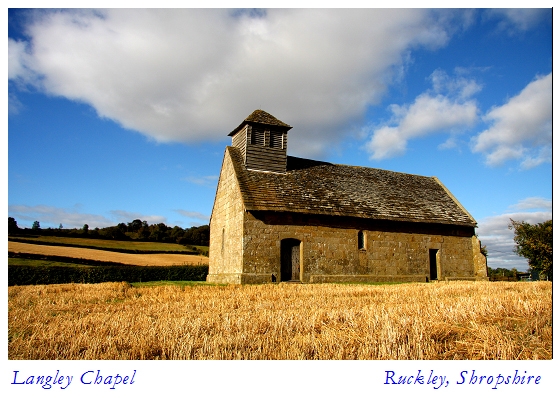
Langley Chapel has no known dedication. It has a simple, rectangular, single
cell design, and is constructed of dressed grey sandstone with a slate tile
roof. Externally the chapel has a chamfered plinth and double chamfered
diagonal buttresses at its eastern angles. There is a small weatherboard bell
tower at the west end, with paired louvred openings and a pyramidal cap. The
two Tudor-arched doorways in the south side have nail-studded boarded doors,
and the easterly doorway has a renewed lintel. Between these is a round-arched
window, while the north wall has a two-light square-headed window. The pointed
window at the chapel's west end, and the bar tracery in the three-light east
window, suggest that the present structure is a reconstruction of an earlier
church. Above the east window is a square recess with a chamfered bottom edge,
which is probably a datestone although at present it is illegible. Internally
the nave and chancel roofs are of different construction. The nave has four
arch-braced collar-beam trusses with moulded pendants carved with faces,
fleurs-de-lis and geometric patterns, while the chancel roof is constructed of
trussed rafters. The nave roof is inscribed with initials and the date 1601,
and on the south side the roof and wall are connected by a plaster frieze
ornamented with Tudor roses, fleurs-de-lis and rosettes. A similar frieze
which decorated the north wall is no longer present.
A restored moulded rood-beam separates the two roofs, and at ground level the
chancel is raised from the nave by a step. It is floored with reused medieval
encaustic tiles, and the furnishings here and in the nave are all of early
17th century date. As the chapel was virtually unused from the late 17th
century it avoided the many subsequent changes in church fashions and as a
result is one of the few places with an almost complete set of church
fittings. Four simple bench pews at the west end of the nave, for the use of
labourers and servants, have poppy-headed finials, and at the far west end is
a higher desk for musicians. Further east, the largest of the ornate panelled
box pews would have been used by the Lee family. There is a small movable
hexagonal pulpit, and an unusual roofed reading desk on the north side of the
nave with benches inside. The box pews, pulpit and reading desk are all
decorated with a carved motif of blank arcades, typical of early Jacobean
work, but lacking the usual elaborate designs within. The movable communion
table is in the centre of the chancel, and is surrounded by seats with
kneelers and bookrests on the north, east and south walls. The iron tie-rods
in the chapel roof date to the restoration of 1900.
The 18th century and modern domestic and agricultural buildings of Langley
Hall Farm and its gardens and farmyard walls, Langley Hall gatehouse, all
fences across the monument, the modern road surface and the modern surfaces of
the farmyard, are all excluded from the scheduling, although the ground
beneath all these features is included.
MAP EXTRACT
The site of the monument is shown on the attached map extract.
It includes a 2 metre boundary around the archaeological features,
considered to be essential for the monument's support and preservation.
Source: Historic England
Around 6,000 moated sites are known in England. They consist of wide ditches,
often or seasonally water-filled, partly or completely enclosing one or more
islands of dry ground on which stood domestic or religious buildings. In some
cases the islands were used for horticulture. The majority of moated sites
served as prestigious aristocratic and seigneurial residences with the
provision of a moat intended as a status symbol rather than a practical
military defence. The peak period during which moated sites were built was
between about 1250 and 1350 and by far the greatest concentration lies in
central and eastern parts of England. However, moated sites were built
throughout the medieval period, are widely scattered throughout England and
exhibit a high level of diversity in their forms and sizes. They form a
significant class of medieval monument and are important for the understanding
of the distribution of wealth and status in the countryside. Many examples
provide conditions favourable to the survival of organic remains.
Langley Hall moated site survives well and is a good example of a large moated
site of high status, one of the most substantial of its kind in the county.
The moat itself is unusually large and designed both to protect the domestic
complex and underline the status of its owner. Evidence for the extent and
layout of the hall, and for any earlier structures on the site, as well as
additions and modifications to its design, will survive as buried features.
The buried remains of other buildings, and archaeological material relating to
the occupation of the site, will survive as stratified deposits throughout the
interior of the moated platform. The earthwork remains of the fishponds and
water mills will retain evidence for their method of construction, and the
ground surfaces sealed beneath the earthworks will retain evidence for land
use immediately prior to their construction. Environmental evidence relating
to the landscape in which the monument was constructed will survive in the
fills of the moat, and organic remains are likely to be preserved in
waterlogged areas. The ridge and furrow further enhances interest in the site
as a self-sufficient unit, and the economic focus of a small hamlet.
Around 4000 parochial chapels were built between the 12th and 17th centuries
as subsidiary places of worship for the convenience of parishioners who lived
at a distance from the main parish church. Some chapels were built as private
places of worship by the upper echelons of society, both for the use of their
family and household, and as a demonstration of the family's wealth and
status. Langley Chapel is a fine example of an early post-medieval parochial
chapel, which is unusual in retaining most of its early 17th century furniture
and fittings substantially intact. The chapel itself is in good condition, and
will retain evidence for its method of construction, including various
refurbishments.
Documentary references to the site further attest its high status, and the
spatial and chronological association of its different elements increases the
interest of the monument as a whole. Evidence for the development of Langley
Hall and Chapel contributes to the wider picture of medieval and post-medieval
Shropshire. When viewed in association with other similar monuments, for
example the moated site at Acton Burnell, 2km to the NNW, the monument
enhances our understanding of the political and social development of the
county from medieval times.
Source: Historic England
Books and journals
The Victoria History of the County of Shropshire : Volume VIII, (1968), 144
The Victoria History of the County of Shropshire : Volume VIII, (1968), 145
The Victoria History of the County of Shropshire : Volume VIII, (1968), 142
Morriss, R, Langley Chapel, Shropshire. A brief guide, (1986), 1-4
Morriss, R, Langley Chapel, Shropshire. A brief guide, (1986), 1
Other
in VCH vol 8, Victoria County History:, Langley Hall in 1789, Victoria County History: VOl 8,
on SMR, Moran, M, Langley Gatehouse, (1966)
SCCAU Report, Hannaford, H, Archaeological excavation and recording ... at Langley Gatehouse, (1991)
Source: Historic England
Other nearby scheduled monuments