Approximate Location Map
Large Map »
This site is entirely user-supported. See how you can help.
If Google Street View is available, the image is from the best available vantage point looking, if possible, towards the location of the monument. Where it is not available, the satellite view is shown instead.
Latitude: 52.7245 / 52°43'28"N
Longitude: -2.3913 / 2°23'28"W
OS Eastings: 373666.620929
OS Northings: 314164.544039
OS Grid: SJ736141
Mapcode National: GBR 066.28P
Mapcode Global: WH9CY.7SJ6
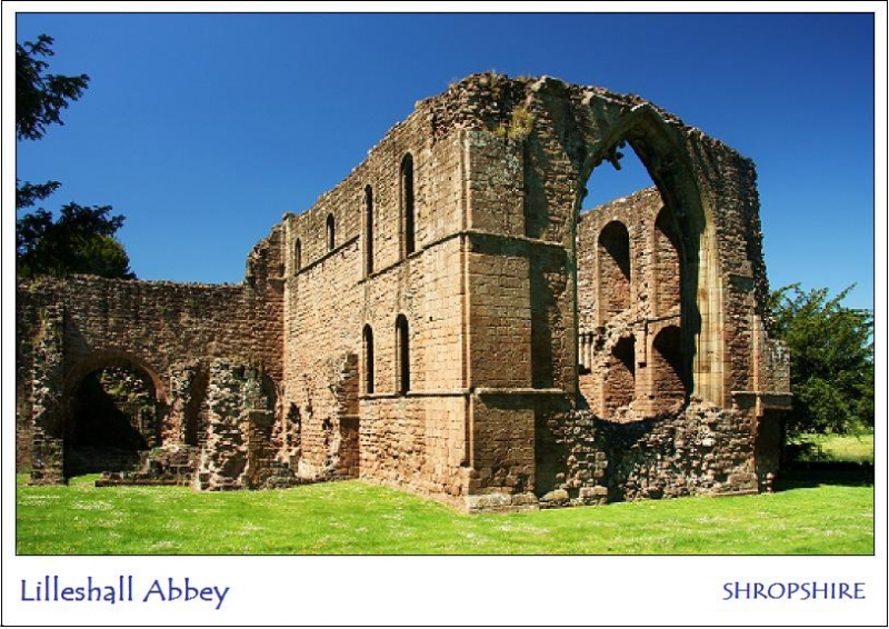
Entry Name: Lilleshall Abbey
Scheduled Date: 8 February 1915
Last Amended: 21 February 1997
Source: Historic England
Source ID: 1015286
English Heritage Legacy ID: 29364
County: Telford and Wrekin
Civil Parish: Donnington and Muxton
Traditional County: Shropshire
Lieutenancy Area (Ceremonial County): Shropshire
Church of England Parish: Lilleshall St Michael and All Angels
Church of England Diocese: Lichfield
The monument includes the ruined, earthwork and buried remains of Lilleshall
Abbey, and the earthwork remains of a disused 18th century canal which bisects
the abbey precinct. In addition it includes, within separate areas, the
earthwork dams of two fishponds situated to the north west of the abbey
precinct. The abbey is located on very gently sloping ground on the east side
of the Tern Valley, 3km SSW of Lilleshall and 6km north of Roman Watling
Street.
The abbey was founded in the mid-12th century for canons of the Arrouasian
order, which was later absorbed by the Augustinians. Brothers Philip and
Richard de Belmeis brought a house of canons from the abbey at Dorchester-on-
Thames to a site at Lizard Grange, some 6km south east of Lilleshall, and had
provided them with a new house on the present site by 1148. The style of the
standing remains at Lilleshall indicates that stone building was begun
immediately to replace the existing, probably timber framed, structures. The
house prospered, expanding and consolidating gifts of new lands for over a
century, and Henry III was entertained at the abbey twice around 1240. In
common with many other abbeys Lilleshall had a financial crisis during the
early 14th century, partly due to haphazard administrative practices. However,
the latter part of the century saw increasing stability, and many lay people
continued to seek admittance to its fraternity. Among these was John of Gaunt,
who spent two days at Lilleshall convalescing after a fever in 1398. Although
the number of brethren dropped after the Black Death, to only ten or eleven
canons around 1400, the abbey's stability continued and a high degree of self-
sufficiency was maintained. One of Lilleshall's canons, John Mirk, gained the
distinction of having one of his religious works printed by Caxton in 1483.
Towards the end of the abbey's life finances again became a problem and many
canons complained about the poor food, while others were accused of seeing
women of bad repute. Some of these failings had been corrected by the
Dissolution, and when the house was dissolved in 1538 it had a gross income of
about 340 pounds. William Cavendish received possession of the site and its
demesnes and a year later the site was granted to James Leveson, whose family
took up residence there and retained possession until the 1920s. Sir Richard
Leveson was a Royalist during the Civil War and in 1656 he fortified and
defended the abbey for several weeks before Parliamentary troops forced an
entry through the north transept of the church. The church towers and Lady
Chapel were ruined in the conflict. In the late 18th century Leveson's
descendant, the Duke of Sutherland was behind the construction of England's
second canal, the line of which can be seen cutting across the monastic
precinct. The abbey site is now in the care of the Secretary of State, and
open to the public. The ruins are Listed Grade I.
The abbey precinct was a roughly oval enclosure, bounded in part by a
substantial wall, stretches of which remain standing to the south east and
north west of the conventual buildings. The precinct is now bisected by the
canal and the modern A518 road. The abbey church was large by Augustinian
standards, cruciform in plan and roughly 70m in length, with an aisleless
nave, quire, square-ended chancel, and north and south transepts each with two
eastern chapels. Its tower was at the west end of the nave rather than at the
crossing, and was completed some time after the other elements of the church.
The cloister was to the south of the church and was also mostly completed in
stone in the late 12th century. The east range consisted of a sacristy
adjoining the transept, a slype and the chapter house. The south range
contained the frater, with a vaulted passage at its east end leading south
from the cloister into an outer court. The west end of the south range was
altered in the 14th century to give access to a kitchen and service rooms
which were shared by the west range. The latter probably replaced earlier
timber structures in the 14th century, and housed an outer parlour, and the
abbot's hall and private chamber. Both were at first floor level above vaulted
undercrofts, with the lodging projecting westwards from the south end of the
hall. The water supply on which the abbey depended as both a domestic and
economic resource was manipulated to feed a number of fishponds and mills
within and beyond the precinct, notably two roughly triangular ponds retained
by substantial dams to the north west of the conventual buildings. The new
water course created by the 18th century canal entered the abbey precinct at
its north east corner and ran south west across it, passing just north of what
is now Abbey Farm.
The standing remains are of sandstone rubble construction with ashlar
dressings. Much of the church still stands to a considerable height, the
earliest part being the east end, which comprises a four-bayed presbytery with
a tomb recess on each side. Its Romanesque details have only been altered by
the insertion of a large 14th century east window, replacing the original
round-headed windows which were probably in two tiers of three. The north and
south walls each have two tiers of windows, and the upper tier continued
westwards to form a clerestory above the roofs of the flanking chapels. A
string course between the tiers is carried internally on imposing corbels of
stepped plan. In the east end of the south wall is a fine processional doorway
which led into the church from the east alley of the cloister. It has a
semicircular arch of three orders, above a segmental arch with a plain lintel
supporting a crescent-shaped tympanum. The outer shaft is decorated with a
spiral motif, and the other shafts, jambs and tympanum are all richly carved
with varieties of chevron and diamond ornament characteristic of the late 12th
century. Although built in the 13th century, the nave fulfils the original
plan of the church, and has a number of Romanesque features deliberately
provided to harmonise with the earlier work. In particular the semicircular
head of the arch of the west door would have been outdated by the 13th
century. However, the stiff-leafed capitals of the door's shafts and the
running foliage on the outer order of the arch are pure 13th century details.
Flanking the arch are the clasping buttresses of the west tower, and the
northern of these retains its broad stopped chamfered angles and an arcade of
three narrow pointed arches. A small north door and the base of a spiral
stairway leading to the tower remain, as do a number of springers rising from
plain corbels, indicating that both nave and tower were vaulted. The footings
of two dividing screens can be seen between the nave and the quire. The
easternmost, the pulpitum, marks the western end of the quire stalls, while
the second is probably a 14th century rood screen, and has the foundations of
nave altars to north and south. A third footing, further west, is probably the
remains of a post-Dissolution adaptation. The foundations of the northern
transept remain, however the arches to its eastern chapels have been blocked.
The south transept stands to a considerable height, and its chapels have
similarly been blocked off, probably before the Dissolution. On the outside
face of the west wall of the transept is a fine Romanesque book locker, with
two compartments rebated for doors and a shaped projection to hold the bolt.
The tympanum, under a semicircular arch, has chevron ornament. South of this
are a doorway and window which date to a post-Dissolution adaptation of the
transept.
The east range stands to a considerable height, and the sacristy and slype
remain roofed. The sacristy had an additional chamber, probably a chapel,
attached to its east end, and both are now blocked off. The vaulted slype is
entered from the east alley of the cloister by another Romanesque doorway with
a crescent-shaped tympanum on both sides, and provided the access from the
cloister to the monk's cemetery. The chapter house has plain walls with two
lateral windows at the east end, and the remains of one of the windows which
would have flanked the doorway in the west wall. Several abbots' graves remain
in the floor of the chapter house. Excavation has revealed the foundations of
the undercroft below the dorter or dormitory, which extended southwards from
the chapter house and survives as a buried feature within the garden of Abbey
Cottage. At the east end of the south range is another Romanesque door leading
to a once-vaulted passage which led to a court to the south of the claustral
ranges, and now leads to the grounds of Abbey Cottage. The rest of the south
range comprised the frater or refectory, which was entered from the cloister
at its west end and retains the foundations of its pulpit at the east end of
the south wall. In the 14th century the frater was divided to provide a
dayroom or warming house with a large fireplace in its eastern half. Against
the partition wall the outer wall was set back to form a new frater pulpit,
and wall recesses on the south side are probably of the same date. The
north-south passage at the west end of the frater was rebuilt at an elevated
level, and its door, ogee-headed windows and fireplace are all of 14th century
date. The remains of the earlier segmental-headed door can be seen at a lower
level. A buttery and pantry, connected to the kitchen, were built on the west
side of the passage, and also served the abbot's hall and lodging in the west
range. At the north end of the north range are the corbels which supported the
ceiling of the passage through the range known as the outer parlour. The
chamfered footings of the porch here date from the post-medieval adaptation of
the range for residential use. Parts of the east wall of the abbot's hall and
the sides of the abbot's chamber stand above ground, showing early 14th
century details, and elsewhere the foundations of the range survive below
ground and are visible as parch marks in dry weather. There are no indications
that the cloister walks themselves were ever vaulted, and the remains of
these, probably timber framed, alleys will also survive as buried features.
The substantial precinct wall, which is Listed Grade I, stands to its full
height for c.160m along the east side of the precinct, turning west at its
southern end and continuing as a foundation visible above ground in some
places until it reaches the grounds of Abbey Lodge. Although modified further
east by the construction of Lillyhurst Road and the development of Abbey Farm,
the line of the boundary can be traced along the track leaving the farm to the
north east, and the wall itself continues as a standing feature up to 1.2m for
roughly 120m to the north west of the conventual buildings. The north end of
the eastern wall was broken through for the construction of the canal, and the
existing terminal of the wall dates to the 18th century. However, its
foundations are exposed in a culvert further north and can be seen continuing
north westwards. The northern boundary of the precinct is marked by a line of
fishponds which can be traced as earthworks along the line of the now
straightened field drain which runs westwards to the north of the church.
The eastern of these ponds has been cut by the construction of the canal, but
its western edge can be traced as a distinct scarp slope up to 1m high. Its
northern edge has been modified by the straightening of the field drain. To
the west is a second roughly oval pond, whose northern edge is marked by a
clear scarp, and which the field drain now roughly bisects east-west. The
western pond is L-shaped and measures up to 110m east-west by up to 80m north-
south, with the field drain marking its southern edge.
A second series of ponds are fed by a spring which rises in the south east
quarter of the precinct. A stew pond was created around this spring, and is
now stone-lined. The water supply between this and the next pond is obscured
by the canal, however it runs north west underground before rising close to
Abbey Court to feed the large triangular pond which is now a feature in its
landscaped gardens. This pond is retained by a dam and wall along its northern
edge, which measures c.100m east-west. It drains north westwards through a now
straightened water course, and feeds a further two triangular ponds. The first
of these is retained by a substantial earthen dam across its north west side,
which measures c.100m long by c.15m wide. An inner masonry revetment wall is
exposed at the north east end of the dam, and at the south west end are the
remains of the sluice which would have controlled water flow out of the pond.
Masonry blocks roughly 0.7m square on either side of the stream have vertical
slots for the timber shutters which would have regulated the outflow. The
outflow channel itself is artificially straightened and partly stone-lined,
and runs north west from the sluice. A now dry spillway diverts northwards off
the outflow and runs along the back of the dam. Towards the centre of the dam
a second outlet emerges and runs north for c.25m before continuing north west
along a field drain. Both channels feed into the third pond, which is also
retained by a dam, c.140m long. The original outflow at the south west end has
been replaced by a later brick and stone sluice, and the outlet channel runs
north east along the back of the pond before turning north west along a
straight field drain. The monastic fishponds would have generated income for
the abbey as well as making an important contribution to the community's food
supply. A sample of the deposits in the two northernmost pond bays along with
their dams and a sample of their outlet channels is protected in two separate
areas. The sluice and bridge at the south end of the north westerly dam are,
however, not included in the scheduling.
Within the precinct the remains of various of the ancillary structures
associated with the monastic community, such as stables, barns, and guest
accommodation, can be seen as building platforms most clearly visible to the
west and north of the triangular fishpond south west of the church. The post
holes and floor levels of these timber framed structures will survive below
ground. The foundations of a dovecot were revealed by excavation and the site
is still visible south of the line of the canal.
The canal itself was only the second to be constructed in England, and was
built in 1774 at the behest of the then Duke of Sutherland, a descendant of
the Leveson family who formerly occupied the abbey. The canal approaches the
abbey precinct from the north and enters roughly the north east corner, where
it turns south west and bisects the precinct. Where infilled the canal can be
traced as a drain along the south side of the private drive, and the remains
of one of the canal locks can be seen where a footbridge crosses this drain
near the entrance to Abbey Court. A stone bridge over the canal near the north
east corner of the precinct is Listed Grade II, and retains a bracket for
telegraph cables. North of the precinct are two hollows extending off the east
side of the canal. One is linear, c.5m wide and c.12m north west-south east.
North of this is a more substantial crescent-shaped depression extending up to
80m north eastwards to encompass the line of a watercourse which spreads in
this area. These are the remains of docking areas, where barges could be
unloaded or worked on. A stretch of the canal incorporating these docking
areas is included in the scheduling, to illustrated the continued use of the
site.
Abbey Cottage, Abbey Court, and all their ancillary buildings and associated
paved and metalled surfaces, garden furniture, metalled track surfaces, the
custodian's hut and kiosk, information boards, all drain covers and modern
gateways and doors within the abbey ruins, the modern wooden steps in the
nave, the shed south of the stew pond, the bridge over the canal, the tennis
courts, all fences around and across the monument, tree guards, and the sign
posts, track surface and jetties at the dam, are all excluded from the
scheduling, although the ground beneath these features is included.
The tennis court at the southern corner of Abbey Court is totally excluded
from the scheduling.
MAP EXTRACT
The site of the monument is shown on the attached map extract.
It includes a 2 metre boundary around the archaeological features,
considered to be essential for the monument's support and preservation.
Source: Historic England
From the time of St Augustine's mission to re-establish Christianity in AD 597
to the reign of Henry VIII, monasticism formed an important facet of both
religious and secular life in the British Isles. Settlements of religious
communities, including monasteries, were built to house communities of monks,
canons (priests), and sometimes lay-brothers, living a common life of
religious observance under some form of systematic discipline. It is estimated
from documentary evidence that over 700 monasteries were founded in England.
These ranged in size from major communities with several hundred members to
tiny establishments with a handful of brethren. They belonged to a wide
variety of different religious orders, each with its own philosophy. As a
result, they vary considerably in the detail of their appearance and layout,
although all possess the basic elements of church, domestic accommodation for
the community, and work buildings. Monasteries were inextricably woven into
the fabric of medieval society, acting not only as centres of worship,
learning, and charity, but also, because of the vast landholdings of some
orders, as centres of immense wealth and political influence. They were
established in all parts of England, some in towns and others in the remotest
of areas. Many monasteries acted as the foci of wide networks including parish
churches, almshouses, hospitals, farming estates and tenant villages. Some 225
of these religious houses belonged to the order of St Augustine. The
Augustinians were not monks in the strict sense, but rather communities of
canons - or priests - living under the rule of St Augustine. In England they
came to be known as `black canons' because of their dark coloured robes and to
distinguish them from the Cistercians who wore light clothing. From the 12th
century onwards, they undertook much valuable work in the parishes, running
almshouses, schools and hospitals as well as maintaining and preaching in
parish churches. It was from the churches that they derived much of their
revenue. The Augustinians made a major contribution to many facets of medieval
life and all of their monasteries which exhibit significant surviving
archaeological remains are worthy of protection.
Lilleshall Abbey is a fine example of an Augustinian abbey which is unusual in
retaining most of its original 12th century fabric substantially unaltered.
Further interest is added by the unusual adoption of Romanesque details on
some of the later elements of the church. The standing remains retain details
of their method of construction, including the building and decorative
techniques employed. The full extent of the claustral ranges and ancillary
structures will remain in the form of post holes and as buried foundations
within the precinct boundary. Floor levels will preserve environmental and
artefact evidence for the activities which took place there. All this
information will enhance our understanding of the relationships of the priory
buildings and their various dates and functions. The subsistence and broader
economic setting of this religious community can be understood in part from
the earthwork remains of the fishponds, which will retain information relating
to their method of construction and operation. The dams will retain
information relating to their construction and the construction and operation
of the sluices and mills they supported. The old ground surface sealed beneath
the dams will retain information relating to land use immediately prior to
their construction. The earthwork remains of the canal and its docking areas
will also retain details of their method of construction, and waterlogged
deposits will preserve environmental evidence relating to the activities
which took place at and around the canal during its use. The masonry remains
of the lock further enhance interest in this element of the site, the
construction of which illustrates the continued significance of the site from
medieval times to beyond the Industrial Revolution.
Documentary evidence attests the high status of the abbey, which is an element
of the wider picture of medieval political and social organisation in
Shropshire.
Source: Historic England
Books and journals
The Victoria History of the County of Shropshire : Volume VIII, (1968), 77
The Victoria History of the County of Shropshire: Volume XI, (1985), 163
Butler, L, Given-Wilson, C, Medieval Monasteries of Great Britain, (1979), 281
Walker, C C, History of Lilleshall, (1891), 18-19
Walker, C C, History of Lilleshall, (1891)
Toms, G, 'Shropshire Newsletter' in Lilleshall Abbey, , Vol. 42, May, (1972), 3
Other
conversation with owner, Davis, John,
DOE (IAM), Ancient monuments of England 3, (1978)
on SMR, Pagett, J, (1957)
photos, plans, Rigold, S E, Lilleshall Abbey, (1969)
SMR SJ7314 A-D,
Watson, Mike, SA 03851, (1984)
Source: Historic England
Other nearby scheduled monuments