Approximate Location Map
Large Map »
This site is entirely user-supported. See how you can help.
If Google Street View is available, the image is from the best available vantage point looking, if possible, towards the location of the monument. Where it is not available, the satellite view is shown instead.
Latitude: 53.3586 / 53°21'31"N
Longitude: -0.8013 / 0°48'4"W
OS Eastings: 479877.00839
OS Northings: 385308.464009
OS Grid: SK798853
Mapcode National: GBR QYVL.BR
Mapcode Global: WHFG4.NVN2
Entry Name: Medieval settlement and open field system immediately south east of Low Farm
Scheduled Date: 19 August 1954
Last Amended: 29 April 1998
Source: Historic England
Source ID: 1017741
English Heritage Legacy ID: 29915
County: Nottinghamshire
Civil Parish: West Burton
Built-Up Area: West Burton Power Station
Traditional County: Nottinghamshire
Lieutenancy Area (Ceremonial County): Nottinghamshire
Church of England Parish: North Wheatley
Church of England Diocese: Southwell and Nottingham
The monument is situated adjacent to the former west bank of the River Trent
and includes the earthwork and buried remains of the medieval settlement
of West Burton. West Burton or `Burtone' was first recorded in the Domesday
Book of 1086 where it is documented that the village was owned by the
Archbishop of York and Roger de Busli and was one of several berewicks
belonging to Laneham. A berewick was a settlement which was physically
separate from the village where the lord lived but still governed as part of
the manorial estate.
A map dating to 1750 illustrates that the village was still in existence at
this time and shows a total of 15 houses and a church on the site. An
account of the village made just over 40 years later records only seven or
eight houses with an estimated population of 45. This decline in the village
continued and by the beginning of the 19th century it had practically
disappeared. A map dating to 1895 clearly shows that the village, with the
exception of the church, was no longer in existence.
The precise reason for the desertion of the village is not clear but can be
inferred from documentary evidence. It is recorded that the land around West
Burton, which was privately enclosed during the 18th century, was of
particularly good quality and, following enclosure, extortionate rent
increases left the farmers with the choice of acceptance or dismission. It is
quite possible that this led to the final abandonment of an already
diminishing village. Another contributing factor may come from the evidence
that around this time the river changed its course. In the immediate vicinity
the River Trent formed two large loops known as the Bole and Burton Rounds
which are clearly visible on modern maps. Gradually the narrow necks of land
were eroded away by the river and in 1792 the river broke through leaving
the old channels to slowly silt up. The river would have been very important
to the economy of the village and possibly provided the main route for
transport in and out of the village. Its change of course would have affected
the community quite drastically.
In 1884 the parish of West Burton was united with that of North and South
Wheatley and, following vestry meetings, a faculty was granted in 1886 to
demolish the disused church at West Burton.
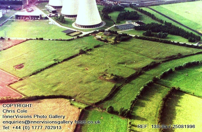
The monument survives as a series of earthworks and buried remains. The
earthworks clearly reflect the basic layout of the village as depicted on the
mid-18th century map, although it appears that the remains have been truncated
by the modern development to the north. It also appears that the site of Low
Farm, a 19th century building, itself now derelict, was the site of earlier
medieval structures.
The north east corner of the village is visible as a line of three rectangular
enclosures or tofts; these are aligned east to west and are bounded by low
earthen banks standing to an average height of 0.5m. At the eastern end of two
of the tofts, traces of slight rectangular platforms indicate the foundations
of medieval houses. The enclosures measure just over 50m long and up to 25m
wide and are marked on the western boundary by a shallow ditch approximately
0.5m deep. This is interpreted as a lane to provide access to the tofts. To
the south of the enclosures are a further two which are roughly square in plan
and measure 50m by 50m. These front onto the main sunken track or hollow way
running through the village. The trackway survives as a wide gully, up to 2m
deep, which runs from the old west bank of the River Trent at the eastern end
to the site of Low Farm at the west end. Three other broad hollow ways are
also evident; these too run east to west and are all parallel to the main
hollow way. The western ends of two of these tracks turn to the north and link
up. From here the trackway continues north to just south of Low Farm where it
turns north west, crosses the modern field boundary, and runs to the edge of
the monument. The trackways are laid out at intervals of between 75m and
100m, separated by extensive village earthworks. At various points along the
hollow ways, and cutting into the banks, are a number of roughly oval-shaped
depressions; these are interpreted as being the result of post-medieval
quarrying.
At the southern end of the monument are a number of other oval-shaped
depressions. These are arranged either side, but set back from, the
southernmost trackway. They are interpreted as ponds and may relate to a
fishery which was recorded in the Domesday Book as `rendering 200 eels'.
To the north of the southernmost track and adjacent to the old west bank of
the River Trent are the remains of two more platforms. These are sub-
rectangular in shape, aligned east to west and are defined by banks up to
0.75m in height. Erosion scars, particularly around the southern most
platform, have exposed areas of dressed stone which are interpreted as being
the foundations of a medieval homestead. This platform is bounded to the south
by a broad gulley which links with the old River Trent to the east and which
turns to the north at the western end of the platform. The gulley continues to
run in a northerly direction until it meets with one of the hollow ways. This
is thought to be a back lane which provided access to the homesteads and which
linked the properties to the main village road system. In effect the back
lane, hollow way and river enclosed both platforms. These platforms are
situated at the lowest point of the village and were likely to be prone to
flooding. This may account for the name `Moaty Yard' which was recorded for
this part of the village on the map of 1750.
Just north of `Moaty Yard' is a large mound on which stood the parish church
of St Helen. The church demolished in 1895 but the churchyard which measures
approximately 43m by 25m survives, surrounded by a fence. A number of
gravestones are still standing but the majority can be found lying in the
grass.
To the north west of the church are the remains of at least two more tofts.
These are defined and separated by shallow ditches with a single low bank
forming the western boundary. Slight traces of house platforms are visible at
the eastern end of the enclosures. A large oval shaped pond lies to the south
of these tofts.
In the field to the south west of Low Farm are further extensive village
earthworks which include faint traces of ridge and furrow (cultivation
strips). These are visible to the south of the hollow way and extend
southwards to approximately half way down the field where they are marked by a
headland. These earthworks are part of the medieval open field system of which
they form part of a single furlong (a group of cultivation strips). The
remains stand to a height of approximately 0.2m.
To the south of this field is a large irregular shaped pond with a narrow
drainage channel extending to the south. Although eroding around its banks,
the pond still contains water. Further village earthworks are visible in this
field but are irregular and difficult to interpret. It is thought that the
earthworks represent different phases in the development of the village. That
there were several phases is not surprising considering the village was active
for over 600 years.
All fences, gates, water troughs, and modern metalled surfaces are excluded
from the scheduling, although the ground beneath all of these features is
included.
MAP EXTRACT
The site of the monument is shown on the attached map extract.
Source: Historic England
Medieval rural settlements in England were marked by great regional diversity
in form, size and type, and the protection of their archaeological remains
needs to take these differences into account. To do this, England has been
divided into three broad Provinces on the basis of each area's distinctive
mixture of nucleated and dispersed settlements. These can be further divided
into sub-Provinces and local regions, possessing characteristics which have
gradually evolved during the last 1500 years or more.
This monument lies in the Pennine Slope sub-Province of the Central Province,
which embraces the varied scarp and vale topography flanking the higher
portions of the southern Pennines, where narrow escarpments of limestone and
sandstone and softer shale vales give a distinct north-south grain to the
landscape. Dispersed settlement increases from extremely low to medium
densities in the south east of the sub-Province to high densities at the north
west. With the exception of Sherwood Forest, the region is well stocked with
nucleated settlements, some old but others the result of 18th- and 19th-
century industrial developments. Anglo-Saxon `wood' names are common among
placenames, and the area was well wooded in 1086.
The Millstone Grit Scarps local region is an undulating terrain of north to
south sandstone ridges separated by vales. It is characterised by village
settlements, with low densities of scattered dwellings and farmsteads between
them. Many of the villages have, however, grown in recent centuries, and the
medieval settlement pattern was of hamlets and farmsteads set in a woodland
landscape.
Medieval villages were organised agricultural communities, sited at the centre
of a parish or township, that shared resources such as arable land, meadow and
woodland. Village plans varied enormously, but when they survive as earthworks
their most distinguishing features include roads and minor tracks, platforms
on which stood houses and other buildings such as barns, enclosed crofts and
small enclosed paddocks. They frequently include the parish church within
their boundaries. In the central province of England, villages were the most
distinctive aspect of medieval life, and their archaeological remains are one
of the most important sources of understanding about rural life in the five or
more centuries following the Norman Conquest.
Medieval villages were supported by a communal system of agriculture based on
large, unenclosed open arable fields. These large fields were subdivided into
strips (known as lands) which were allocated to individual tenants. The
cultivation of these strips with heavy ploughs pulled by oxen-teams produced
long, wide ridges and the resultant `ridge and furrow' where it survives is
the most obvious physical indication of the open field system. Individual
strips or lands were laid out in groups known as furlongs defined by terminal
headlands at the plough turning-points and lateral grass baulks. Furlongs were
in turn grouped into large open fields. Well preserved ridge and furrow,
especially in its original context adjacent to village earthworks, is both an
important source of information about medieval agrarian life and a distinctive
contribution to the character of the historic landscape. It is usually now
covered by the hedges or walls of subsequent field enclosure.
The earthwork and buried remains of the medieval settlement of West Burton are
particularly well preserved and retain significant archaeological deposits.
The earthworks and historical documentation provide a clear picture of the
village layout and how it fitted within the wider environment. The documentary
sources also provide evidence of how the village was administered and data
indicating reasons for its desertion. Taken as a whole, the medieval
settlement of West Burton will add greatly to our knowledge and understanding
of the development of settlement in the area during this period.
This monument has been reviewed and the mapped depiction amended to more
accurately reflect the extent of the remains in the area immediately east of
Low Farm.
Source: Historic England
Books and journals
Page, W (ed), The Victoria History of the County of Nottinghamshire, (1906), 255-267
Throsby, J, Thorotons History of Nottinghamshire: Volume 3, (1796), 300-301
Holland, D, 'Transactions of the Thoroton Society' in A Note On The Deserted Village Of West Burton, , Vol. 71, (1967), 70-71
Other
Title: Map showing the alteration of the boundary between the counties
Source Date: 1895
Author:
Publisher:
Surveyor:
Title: West Burton Village in 1750
Source Date: 1750
Author:
Publisher:
Surveyor:
Source: Historic England
Other nearby scheduled monuments