Approximate Location Map
Large Map »
This site is entirely user-supported. See how you can help.
If Google Street View is available, the image is from the best available vantage point looking, if possible, towards the location of the monument. Where it is not available, the satellite view is shown instead.
Latitude: 51.8067 / 51°48'24"N
Longitude: -1.6056 / 1°36'20"W
OS Eastings: 427285.861925
OS Northings: 212085.080137
OS Grid: SP272120
Mapcode National: GBR 5SX.NVW
Mapcode Global: VHBZT.4V0B
Entry Name: Medieval settlement of Widford immediately east of Manor Farm
Scheduled Date: 24 February 2004
Source: Historic England
Source ID: 1020970
English Heritage Legacy ID: 30828
County: Oxfordshire
Civil Parish: Swinbrook and Widford
Traditional County: Oxfordshire
Lieutenancy Area (Ceremonial County): Oxfordshire
Church of England Parish: Asthall with Swinbrook and Widford
Church of England Diocese: Oxford
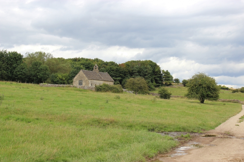
The monument includes the known surviving extent of the buried and
earthwork remains of the medieval settlement of Widford as well as an
earlier Romano-British bath house located toward the eastern side of the
settlement, beneath St Oswald's Church. It is situated at the intersection
of the valley of the River Windrush and a smaller dry valley (running
north to south) called Dean Bottom. The settlement lies on the north side
of the Windrush on a slight terrace, just above the normal level of winter
flooding.
The earthworks marking the location of the settlement cover an area
roughly 240m from east to west and 160m from north to south, within the
fields to the east of Manor Farm. The earthworks define a series of
platforms measuring from roughly 20 sq m to over 100m across separated by
hollow ways which mark the individual buildings and plots, the majority of
which lie to the north and west of the Church of St Oswald.
The area of settlement formerly extended to the north and west, however
quarrying and later agricultural activity in these areas have removed some
of the remains, and they are not, therefore, included in the scheduling.
St Oswald's Church was owned by the Priory of St Oswald at Gloucester in
1086 and, although most of the present fabric is 12th century in date or
later, there may well have been an earlier church on the site. Local
tradition suggests that it may have been built to mark a resting place of
St Oswald's body on its journey south from Northumbria to Gloucester in
AD 642. The church, which is Listed Grade II*, contains a number of
important 13th and 14th century wall paintings which were uncovered during
restoration work in 1904 and later conserved. During restoration of the
church evidence for an earlier Roman structure beneath it was discovered.
This included a black and red lozenge patterned tessellated floor along
with fragments of box flue tile, indicating the presence of a heated
floor. These and further finds within the graveyard suggest that the
building was a bath house, probably fed by the spring in the pond
immediately to the north. Water channels which originally led under the
church are visible as earthworks to the north but were later rerouted
around the churchyard. Further earthwork fragments some distance to the
north suggest that the main Roman building to which the bath belonged may
well have been situated further north, somewhere in the vicinity of the
present 17th century Manor Farm House. However, the nature and location of
these remains are not fully understood and this area is not included in
the scheduling.
The name Widford derives from an Anglo-Saxon geographical place name
meaning `the ford by the willow trees'. Its earliest known spelling was as
`Withig ford' and Widford is mentioned in the Domesday book of 1086. The
name suggests that the ford here was an important river crossing point
before the establishment of the settlement which later took its name from
the location.
The northern portion of the churchyard is in use for burial and totally
excluded from the scheduling, both above and below ground.
St Oswald's Church and all post and wire fences are excluded from the
scheduling, although the ground beneath these features is included.
MAP EXTRACT
The site of the monument is shown on the attached map extract.
Source: Historic England
Medieval rural settlements in England were marked by great regional diversity
in form, size and type, and the protection of their archaeological remains
needs to take these differences into account. To do this, England has been
divided into three broad Provinces on the basis of each area's distinctive
mixture of nucleated and dispersed settlements. These can be further divided
into sub-Provinces and local regions, possessing characteristics which have
gradually evolved during the past 1500 years or more.
The South Midlands local region is large, and capable of further subdivision.
Strongly banded from south west to north east, it comprises a broad succession
of clay vales and limestone or marlstone ridges, complicated by local drifts
which create many subtle variations in terrain. The region is in general
dominated by nucleated villages of medieval origin, with isolated farmsteads,
mostly of post-medieval date, set in the spaces between them. Depopulated
village sites are common, and moated sites are present on the claylands.
Medieval villages were organised agricultural communities, sited at the
centre of a parish or township, that shared resources such as arable land,
meadow and woodland. Village plans varied enormously, but when they
survive as earthworks their most distinctive features include roads and
minor tracks, platforms on which stood houses and other buildings such as
barns, enclosed crofts and small enclosed paddocks. They frequently
included the parish church within their boundaries, and as part of the
manorial system most villages included one or more manorial centres which
may also survive as visible remains as well as below ground deposits. In
the Central Province of England, villages were the most distinctive aspect
of medieval life, and their archaeological remains are one of the most
important sources of understanding about rural life in the five or more
centuries following the Norman Conquest.
Widford is a good example of a nucleated medieval settlement, within the
South Midlands local region, and survives well as a series of visible
earthworks centred immediately west of the Church of St Oswald. Evidence
provided by aerial photographs, field survey, observations over time,
partial excavation within the church and documented history have shown
that the settlement contains largely undisturbed archaeological remains
relating to the development, occupation and economy of the village from
its original establishment up to and beyond its final abandonment. In
addition, the church lies on the site of an earlier Roman building and
archaeological evidence for earlier Roman activity is known to survive
elsewhere beneath much of the village. This may provide information about
earlier settlement and the nature of change in the post-Roman period.
Source: Historic England
Other
PRN 1480, SMRO, Roman Villa, site of., (1993)
PRN1105 & 5728, SMRO, Widford Deserted Medieval Settlement, (1994)
PRN1105, SMRO, Widford Shrunken Village, (1993)
PRN4054, SMRO, St Oswald's Church, (1993)
Source: Historic England
Other nearby scheduled monuments