Approximate Location Map
Large Map »
This site is entirely user-supported. See how you can help.
If Google Street View is available, the image is from the best available vantage point looking, if possible, towards the location of the monument. Where it is not available, the satellite view is shown instead.
Latitude: 50.4209 / 50°25'15"N
Longitude: -5.0168 / 5°1'0"W
OS Eastings: 185798.911752
OS Northings: 62247.529502
OS Grid: SW857622
Mapcode National: GBR ZG.XKF4
Mapcode Global: FRA 07CY.5CS
Entry Name: St Pedyr's Well, Treloy
Scheduled Date: 8 October 1956
Last Amended: 21 January 1999
Source: Historic England
Source ID: 1018575
English Heritage Legacy ID: 31834
County: Cornwall
Civil Parish: Colan
Traditional County: Cornwall
Lieutenancy Area (Ceremonial County): Cornwall
Church of England Parish: St Columb Minor and Colan
Church of England Diocese: Truro
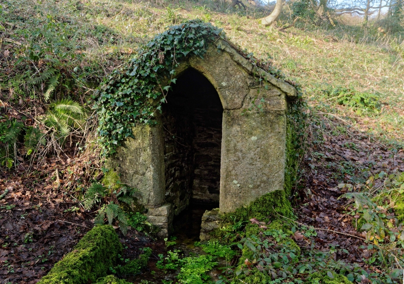
The monument includes a medieval holy well at Treloy, which survives as a
small stone building with two stone benches to either side of the entrance,
and is located over a spring. The well house measures 2.03m north-south by
1.75m east-west. There is a granite pointed arched doorway in the south face,
giving access to the well basin. The well basin contains clear water which
flows out of the well entrance and down towards a nearby stream. The walls of
the well-house are constructed of the local stone and the roof comprises large
slabs of stone. The benches to either side of the entrance are low stone
walls, the one to the west has a large slab of worked granite placed on it,
possibly part of a window mullion. To the east of the well-house is a granite
window arch embedded in the ground, probably from the site of an adjacent
chapel, of which there are no visible remains.
The well and chapel of St Pedyr were first mentioned in the 17th century,and
in 1694 two people from Stratton in north Cornwall were given money to journey
to the well to seek a cure for their legs. By 1824 the well had fallen into
decay, but had been restored by 1894 when it was described as being in good
condition and popular with artists and visitors, By 1925 the well was again
falling into ruin, but it was restored by the Newquay Old Cornwall Society in
1953.
MAP EXTRACT
The site of the monument is shown on the attached map extract.
It includes a 2 metre boundary around the archaeological features,
considered to be essential for the monument's support and preservation.
Source: Historic England
A medieval chapel is a building, usually rectangular, containing a range of
furnishings and fittings appropriate for Christian worship in the pre-
Reformation period. Chapels were designed for congregational worship and were
generally divided into two main parts: the nave, which provided accommodation
for the laity, and the chancel, which was the main domain of the priest and
contained the principal altar. Around 4000 parochial chapels were built
between the 12th and 17th centuries as subsidiary places of worship built for
the convenience of parishioners who lived at a distance from the main parish
church. Other chapels were built as private places of worship by manorial
lords and lie near or within manor houses, castles or other high-status
residences. Chantry chapels were built and maintained by endowment and were
established for the singing of masses for the soul of the founder. Some
chapels possessed burial grounds. Unlike parish churches, the majority of
which remain in ecclesiastical use, chapels were often abandoned as their
communities and supporting finances declined or disappeared. Many chantry
chapels disappeared after the dissolution of their supporting communities in
the 1540s.
Chapels, like parish churches, have always been major features of the
landscape. A significant number of surviving examples are identified as being
nationally important. The sites of abandoned chapels, where positively
identified, are particularly worthy of statutory protection as they were often
left largely undisturbed and thus retain important information about the
nature and date of their use up to their abandonment.
St Pedyr's holy well survives well, despite some restoration in the 19th and
20th centuries. The well house dates from the medieval period and with
its adjacent chapel would have been an important centre for pilgrimage by
those seeking cures.
Source: Historic England
Books and journals
Lane-Davies, A, Holy Wells of Cornwall, (1970)
Quiller Couch, L, Quiller Couch, M, Ancient and Holy Wells of Cornwall, (1894)
Other
Consulted July 1997, Cornwall SMR entry for PRN No.22143,
Consulted July 1998, FMW report for CO 412,
Title: 1:25000 Ordnance Survey Map; SW 86/96; Pathfinder Series 1346
Source Date: 1985
Author:
Publisher:
Surveyor:
Source: Historic England
Other nearby scheduled monuments