Approximate Location Map
Large Map »
This site is entirely user-supported. See how you can help.
If Google Street View is available, the image is from the best available vantage point looking, if possible, towards the location of the monument. Where it is not available, the satellite view is shown instead.
Latitude: 54.9983 / 54°59'54"N
Longitude: -1.5242 / 1°31'27"W
OS Eastings: 430535.212113
OS Northings: 567187.899357
OS Grid: NZ305671
Mapcode National: GBR KBSN.T1
Mapcode Global: WHC3L.KMDK
Entry Name: Holy Cross Church and graveyard, Wallsend
Scheduled Date: 7 October 1983
Last Amended: 2 December 1998
Source: Historic England
Source ID: 1018643
English Heritage Legacy ID: 32053
County: North Tyneside
Electoral Ward/Division: Howdon
Built-Up Area: Wallsend
Traditional County: Northumberland
Lieutenancy Area (Ceremonial County): Tyne and Wear
Church of England Parish: Wallsend St Peter and St Luke
Church of England Diocese: Newcastle
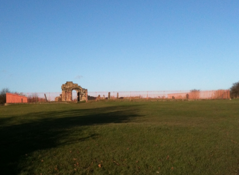
The monument includes the remains of Holy Cross Church, situated on the
top of a spur, which is bounded to the north, west and south by a deep
ravine through which the Wallsend Burn flows. The visible remains of the
church, which is Listed Grade I, include a chancel, nave, porch and associated
graveyard.
The chancel and nave form a tapering rectilinear structure approximately 16m
in length and 7.2m wide at the western end of the nave, tapering to 6.5m wide
at the eastern end of the chancel. Internally the chancel measures 3.6m by
4.7m and the nave measures 9.3m by 5.3m. Within the nave is a font base. In
the north wall of the nave are two doorways, one blocked and one open. The
walls of the nave and chancel stand to only three to five courses high (1m-
1.5m). However, the south wall of the nave around the south doorway is
preserved to a height of 4m. The southern doorway is a semi-circular Norman
arch and is considered to include re-used Roman material. To the exterior of
the nave are three buttresses: two diagonal buttresses on the north west and
south west corners of the nave and a square buttress on the north wall.
The porch was added, in the 17th century, onto the south doorway of the nave.
The side walls of the porch stand to a height of approximately 1.5m. A stone
seat runs against each side wall. The south wall of the porch stands to
approximately 2.5m.
The associated graveyard as depicted on first edition Ordnance Survey maps
filled the spur that the church resides on. The boundary bank and hedge can
still be detected on some of the south and east side. The bank can be seen on
the east side, where it is 0.25m high and 2m wide, and is occasionally
surmounted by a hedge of hawthorn. To the south the boundary is obscured by
scrub growth, but portions of the hawthorn hedge can still be seen above this
growth. To the west and north the line of the boundary is not visible but
followed the top of the steep slope on these sides. The remaining gravestones
of the graveyard were moved into a iron railing fenced area surrounding the
church in 1909.
The first reference to a church at Wallsend is in the late 12th century in
a bull from Pope Urban to Germanus, prior of Durham confirming to him the
church of Wallsend. Numerous tithe records are contained within the Jarrow
account rolls for the 14th and 15th century. The church continued in use until
1797. The last burial occurred in 1842. In 1909 the interior of the church was
cleared of accumulated debris, the walls consolidated and an iron railing
fence erected enclosing the majority of visible gravestones. Although normally
referred to as a church, the ecclesiastical status of the site was a parochial
chapel.
Associated with the church were two access routeways. One, a paved churchway,
led from Wallsend village to the foot of a series of steps leading up the side
of the ravine to the south of the church. The original steps were removed in
1845. The other was a hearse road from Willington village, which began at West
Farm, led down to and followed the north side of the Wallsend Burn before
leading up to the church on the west side of the hill.
The iron railing fence is excluded from the scheduling, although the ground
beneath it is included.
MAP EXTRACT
The site of the monument is shown on the attached map extract.
It includes a 2 metre boundary around the archaeological features,
considered to be essential for the monument's support and preservation.
Source: Historic England
A medieval chapel is a building, usually rectangular, containing a range of
furnishings and fittings appropriate for Christian worship in the pre-
Reformation period. Chapels were designed for congregational worship and were
generally divided into two main parts: the nave, which provided accommodation
for the laity, and the chancel, which was the main domain of the priest and
contained the principal altar. Around 4000 parochial chapels were built
between the 12th and 17th centuries as subsidiary places of worship built for
the convenience of parishioners who lived at a distance from the main parish
church. Other chapels were built as private places of worship by manorial
lords and lie near or within manor houses, castles or other high-status
residences. Chantry chapels were built and maintained by endowment and were
established for the singing of masses for the soul of the founder. Some
chapels possessed burial grounds. Unlike parish churches, the majority of
which remain in ecclesiastical use, chapels were often abandoned as their
communities and supporting finances declined or disappeared. Many chantry
chapels disappeared after the dissolution of their supporting communities in
the 1540s.
Chapels, like parish churches, have always been major features of the
landscape. A significant number of surviving examples are identified as being
nationally important. The sites of abandoned chapels, where positively
identified, are particularly worthy of statutory protection as they were often
left largely undisturbed and thus retain important information about the
nature and date of their use up to their abandonment.
Holy Cross Church is a well preserved example of a medieval parochial chapel.
The church and its associated graveyard have not been disturbed and will
preserve deposits pertaining to the construction and use of the monument.
Source: Historic England
Books and journals
Richardson, W, History of the Parish of Wallsend, (1923), 110-122
Blair, R, 'Proceedings of the Society of Antiquities, Newcastle on Tyne' in Wallsend Old Church, , Vol. 3, IV, (1909), 162-163
Knowles, W H, 'Archaeologia Aeliana' in The Church of the Holy Cross, Wallsend, Northumberland, , Vol. 3, VI, (1910), 191-203
Other
Contained in Tyne and Wear SMR, Wallsend Local History Society, Holy Cross Church, Wallsend,
Source: Historic England
Other nearby scheduled monuments