Approximate Location Map
Large Map »
This site is entirely user-supported. See how you can help.
If Google Street View is available, the image is from the best available vantage point looking, if possible, towards the location of the monument. Where it is not available, the satellite view is shown instead.
Latitude: 54.9217 / 54°55'18"N
Longitude: -1.442 / 1°26'31"W
OS Eastings: 435864.772982
OS Northings: 558698.257192
OS Grid: NZ358586
Mapcode National: GBR V2Q.6L
Mapcode Global: WHD54.TKJ9
Entry Name: Hylton Castle: a medieval fortified house, chapel, 17th and 18th century country houses and associated gardens
Scheduled Date: 23 August 1928
Last Amended: 10 January 2000
Source: Historic England
Source ID: 1017223
English Heritage Legacy ID: 32074
County: Sunderland
Electoral Ward/Division: Castle
Built-Up Area: Sunderland
Traditional County: Durham
Lieutenancy Area (Ceremonial County): Tyne and Wear
Church of England Parish: North Wearside
Church of England Diocese: Durham
The monument includes the site and remains of a medieval fortified house
modified throughout the 17th and 18th centuries, alongside the remains of its
17th century and later gardens and medieval ridge and furrow cultivation.
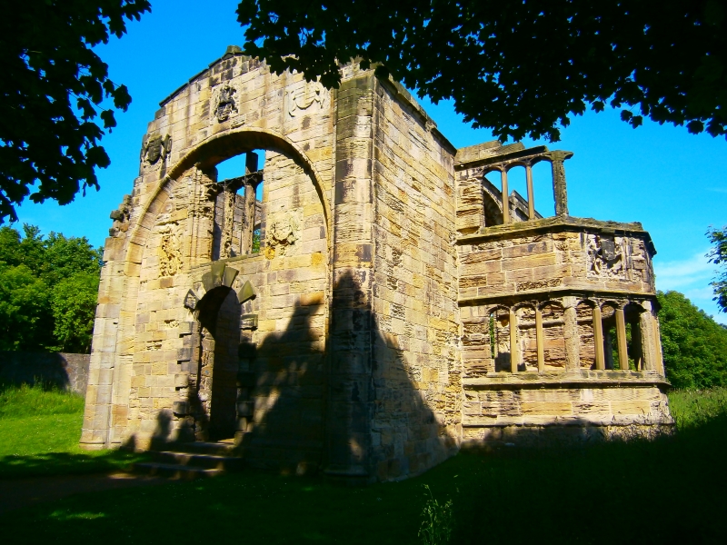
The only upstanding remains of the house are the gatehouse tower, a large
towerhouse of c.1400 built over the west gateway and the house. The gatehouse
was built by Sir William Hylton, whose family had held the manor since at
least 1157. The gatetower remained the family's principal residence throughout
the 15th and 16th centuries. It is a substantial rectangular building of well
covered ashlar and was originallly four-storeyed. The gate is flanked by two
square turrets and surmounted by a rich display of heraldic devices which
provide important evidence for the tower's date. The gatehouse was blocked by
a stone decorative screen to the exterior of a central east turret on the east
internal wall.
Around all but the north wall of the tower, the parapets around the roof and
turrets project forward from the walls on supporting corbels. The ground floor
included a central gate-passage flanked by vaulted chambers. Those on the
north side were used as storerooms while those on the south side functioned as
the guardroom and a private chamber.
The first floor was occupied by the baron's hall and solar, and also a kitchen
with an attached buttery and pantry. The latter lay at the south or `low' end
of the hall, farthest from the baron's table at the north end of the hall. The
hall was lit by three main windows. The central window was located above the
gate, and below it in the floor was a slot through which the portcullis could
be raised, worked via a winding mechanism located in a mural chamber in the
southern of the central turrets. Access to the hall was via a newel stair in
the projecting central east turret. Also, in the projecting east turret, and
adjacent to the entrance to the hall, was the oratory or private chapel. To
the north of the hall was the solar, a private chamber, equipped with a
garderobe and at least one window seat. There would have been a fireplace in
the south wall which divided the chamber from the hall, but this was
demolished during 18th century alterations. Three similar private chambers
existed on the second floor; one lay above the solar and would have been for
the baron's family and the other was above the oratory and was the chaplain's
lodgings. Both of these were accessed from the hall via a stair at the
northern end of the central east turret. The third private chamber on the
second floor was over the kitchens and was accessed via the main stair at the
southern end of the central east turret. A further two private chambers
existed above the chaplain's lodgings in the central east tower accessed via
the main stair. The gatetower formed the west side of a courtyard arrangement
of buildings which has been identified by geophysical survey and excavation in
1994 and 1995. Externally, these buildings measure about 50m long by 30m wide.
A hall, mentioned in a survey of 1435 and slightly revealed by excavation an
1993, would have formed the east range of the courtyard with service rooms and
kitchen at its `low' or southern end. The south range of the courtyard was a
barn and the north range contained chambers to provide additional
accommodation. The evidence from the excavations indicate that these buildings
had not been in use after the medieval period. A 17th century country house
identified from geophysical survey as 50m long and 20m wide is located about
70m east of the gatetower.
In 1640 the manor was bequeathed by Henry Hylton to the Corporation of London.
After a lengthy legal battle, the estate was returned to Henry's nephew, John
Hylton, at high financial cost as he had to discharge the conditions of the
will and settle the claims of rival contestants. By 1700 the gatetower became
the basis for a large house, which was built in two phases between 1700 and
the death of the last Baron Hylton in 1746, along with a number of alterations
to the interior of the gatetower. A north wing was added between 1700 and
1712, and a matching south wing was constructed between 1712 and 1746. The
north wing no longer survives as a standing feature and the south wing has
three courses of ashlar sandstone blocks upstanding. The wings were demolished
in the 1860s by the then owner, William Briggs who also `medievalised' the
entrances and windows and gave the gatetower its present appearance. His
internal alterations were removed when the gatetower was taken into the
Secretary of State's care in 1950. The general appearance of the 18th century
house is known, however, from a number of contemporary illustrations, most
notably an engraving by Samuel and Nathaniel Buck, dated 1728, and a painting
by an unknown artist, dated about 1800. The ground plans of the demolished
wings also survive as buried features.
A separate chapel, dedicated to St Catherine, is known to have existed at
Hylton since 1157. No standing remains of this early structure survive but
buried remains of this chapel and those of subsequent medieval chapels, will
survive beneath the present ruined chapel. This was built in the early 15th
century and altered by the insertion of an east window in the late 15th or
early 16th century and the addition of two-storey transepts in the late 16th
century, after the Reformation. The first chapel was founded by Romanus of
Hylton and, in the 13th century, permission was given for members of the
family and household to be buried there. This led, in the 14th century, to the
founding of chantries (endowments for the singing of masses for the souls of
the dead). In 1322 there was one chantry, dedicated to the Virgin Mary, and,
in 1370, there were three chantry priests. The last chaplain was appointed in
1536. After that, the chapel may have continued in use as a burial place, but
it had clearly gone out of use by 1728 as the Buck engraving shows it as
roofless. The last Baron Hylton, who died in 1746, carried out some repairs
and temporarily restored it to use, as did the early 19th century owner, Simon
Temple. During the 19th and 20th centuries, however, it fell into disrepair
and was saved from demolition at the same time as the tower.
The landscape around the surviving upstanding remains of Hylton Castle and
chapel is of at least two phases, a 17th century garden, and a 19th century
landscaped park. The remains of the 17th century gardens include three
terraces (a lower terrace to the east of the gatetower, an upper terrace to
the east of the chapel, and a terrace to the west of the gatetower), and a
canal water feature. The lower terrace is 218m long and 45m wide and overlies
a stretch of 10m wide ridge and furrow cultivation, which is visible to the
east of this terrace. The upper terrace, to the east of the chapel, is 100m
long and tapers from 28m wide near the chapel to 18m. Access from the lower to
the upper terrace is by two earth ramps cut into its slope. These are 2m wide
by 30m long. A map of the Sunderland area by Burleigh and Thompson, published
in 1737, uses as a vignette an elevation of Hylton Castle and shows a knot
garden on the upper terrace with a wall at its east end. Information on this
garden layout will be preserved beneath the present ground surface. The
terrace to the west of the gatetower is about 90m long by 100m wide and was
the main access to Hylton Castle. These terraces would have been laid out to
gardens and incorporated recreational facilities such as a bowling green
recorded in the estate sale of 1750. The canal water feature is situated about
190m south of the gatetower and measures 70m long by 14m wide. In the 19th
century the area around Hylton Castle was turned into a landscaped park. A
vista from the gatetower to the west was created by an avenue between wooded
areas and a walled garden was established to the north of this avenue, about
250m north west of the gatetower. Other earthworks associated with the 17th
century gardens and 19th century landscaped park survive within the vicinity
of Hylton Castle but remain undated and further remains will be preserved
beneath the present ground surface, which will provide important information
on the development of the surrounding landscape. Excavation 140m south of the
gatetower has confirmed that features associated with the gardens survive,
uncovering a 19th century track which overlay an earlier, undated kerbed
track.
The gatehouse and chapel are Grade I Listed Buildings and are in the care of
the Secretary of State.
The wooden post and rail fence, the iron railings, football goal, playground
apparatus and surfaces, and the surfaces of metalled paths are excluded from
the scheduling, although the ground beneath them is included.
MAP EXTRACT
The site of the monument is shown on the attached map extract.
Source: Historic England
Fortified houses were residences belonging to some of the richest and most
powerful members of society. Their design reflects a combination of domestic
and military elements. In some instances, the fortifications may be cosmetic
additions to an otherwise conventional high status dwelling, giving a military
aspect while remaining practically indefensible. They are associated with
individuals or families of high status and their ostentatious architecture
often reflects a high level of expenditure. The nature of the fortification
varies, but can include moats, curtain walls, a gatehouse and other towers,
gunports and crenellated parapets.
Their buildings normally included a hall used as communal space for domestic
and administrative purposes, kitchens, service and storage areas. In later
houses the owners had separate private living apartments, these often
receiving particular architectural emphasis. In common with castles, some
fortified houses had outer courts beyond the main defences in which stables,
brew houses, granaries and barns were located.
Fortified houses were constructed in the medieval period, primarily between
the 15th and 16th centuries, although evidence from earlier periods, such as
the increase in the number of licences to crenellate in the reigns of Edward I
and Edward II, indicates that the origins of the class can be traced further
back. They are found primarily in several areas of lowland England: in upland
areas they are outnumbered by structures such as bastles and tower houses
which fulfilled many of the same functions. As a rare monument type, with
fewer than 200 identified examples, all examples exhibiting significant
surviving archaeological remains are considered of national importance.
A medieval chapel is a building, usually rectangular, containing a range of
furnishings and fittings appropriate for Christian worship in the
pre-Reformation period. Chapels were designed for congregational worship and
were generally divided into two main parts: the nave, which provided
accommodation for the laity, and the chancel, which was the main domain of the
priest and contained the principal altar. Around 4000 parochial chapels were
built between the 12th and 17th centuries as subsidiary places of worship for
the convenience of parishioners who lived at a distance from the main parish
church. Other chapels were built as private places of worship by manorial
lords and lie near or within manor houses, castles or other high-status
residences. Chantry chapels were built and maintained by endowment and were
established for the singing of masses for the soul of the founder. Some
chapels possessed burial grounds. Unlike parish churches, the majority of
which remain in ecclesiastical use, chapels were often abandoned as their
communities and supporting finances declined or disappeared. Many chantry
chapels disappeared after the dissolution of their supporting communities in
the 1540s.
Chapels, like parish churches, have always been major features of the
landscape. A significant number of surviving examples are identified as being
nationally important. The sites of abandoned chapels, where positively
identified, are particularly worthy of statutory protection as they were often
left largely undisturbed and thus retain important information about the
nature and date of their use up to their abandonment.
Country houses of the late Tudor and early Jacobean period comprise a
distinctive group of buildings which differ in form, function, design and
architectural style from country houses of both earlier and later date. Built
after the Dissolution of the Monasteries, they are the product of a particular
historical period in which a newly-emerged Protestant elite of lawyers,
courtiers, diplomats and other officials, mostly with close contacts at court,
competed with each other to demonstrate wealth, taste and loyalty to the
sovereign, often overstretching themselves financially. Their houses are a
development of the medieval hall with flanking wings and a gatehouse, often
looking inwards onto a courtyard; later examples tend to built outwards,
typically on a U- or H-plan. The hall was transformed from a reception area to
an entrance vestibule and the long gallery and loggia were introduced. Many
houses were provided with state apartments and extensive lodgings for the
accommodation of royal visitors and their retinues.
Country houses of this period were normally constructed under the supervision
of one master-mason or a succession of masons, often combining a number of
designs drawn up by the master-mason, surveyor or by the employer himself.
Many designs and stylistic details were copied from Continental pattern-books,
particularly those published in the 1560s on French, Italian and Flemish
models; further architectural ideas were later spread by the use of foreign
craftsmen. Symmetry in both plan and elevation was an overriding principle,
often carried to extremes in the Elizabethan architectural 'devices' in which
geometric forms were employed to express religious and philosophical ideas.
Elements of Classical architecture were drawn on individually rather than
applied strictly in unified orders. This complex network of influences
resulted in liberal and idiosyncratic combinations of architectural styles
which contrasted with the adoption of the architecture of the Italian
Renaissance, and with it the role of the architect, later in the 17th century.
About 5000 country houses are known to have been standing in 1675; of these
about 1000 are thought to survive, although most have been extensively altered
or rebuilt in subsequent centuries to meet new demands and tastes. Houses
which are uninhabited, and thus been altered to a lesser degree, are much
rarer. Surviving country houses of the late Tudor and early Jacobean period
stand as an irreplaceable record of an architectural development which was
unique both to England and to a particular period in English history
characterised by a flourishing of artistic invention; they provide an insight
into politics, patronage and economics in the early post-medieval period. All
examples with significant surviving archaeological remains are considered to
be of national importance.
Post-medieval formal gardens are garden arrangements dating between the early
16th and mid-18th centuries, their most characteristic feature being a core of
geometric layout, typically located and orientated in relation to the major
residences of which they formed the settings. Garden designs of this period
are numerous and varied, although most contain a number of recognisable
components. For the 16th and 17th centuries, the most common features are
flat-topped banks or terraces (actually raised walkways), waterways, closely
set ponds and multi-walled enclosures. Late 17th and 18th century gardens
often reflect the development of these ideas and contain multiple terraces and
extensive water features, as well as rigidly geometrical arrangements of
embankments. Other features fashionable across the period include: earthen
mounds (or mounts) used as vantage points to view the house and gardens, or as
the sites of ornate structures; `moats' surrounding areas of planting; walled
closes of stone or brick (sometimes serving as the forecourt of the main
house); and garden buildings such as banqueting houses and pavilions. Planted
areas were commonly arranged in geometric beds, or parterres, in patterns
which incorporated hedges, paths and sometimes ponds, fountains and statuary.
By contrast, other areas were sometimes set aside as romantic wildernesses.
Formal gardens were created throughout the period by the royal court, the
aristocracy and country gentry, as a routine accompaniment of the country
seats of the landed elite. Formal gardens of all sizes were once therefore
commonplace, and their numbers may have comfortably exceeded 2000. The radical
redesign of many gardens to match later fashions has dramatically reduced this
total, and a little more than 250 examples are currently known in England.
Although one of many post-medieval monument types, formal gardens have a
particular importance reflecting the social expectations and aspirations of
the period. They represent a significant and illuminating aspect of the
architectural and artistic tastes of the time, and illustrate the skills which
developed to realise the ambitions of their owners. Surviving evidence may
take many forms, including standing structures, earthworks and buried remains;
the latter may include details of the planting patterns, and even
environmental material from which to identify the species employed. Examples
of formal gardens will normally be considered to be of national importance,
where the principal features remain visible, or where significant buried
remains survive; of these, parts of whole garden no longer in use will be
considered for scheduling.
The remains of the medieval fortified house known as Hylton Castle and
associated monuments provide an important source of information on the
development of the residence and landscape of an important local family from
the medieval period to the 19th century. Significant information on the
development of buildings and gardens will be preserved beneath the present
ground surface.
Source: Historic England
Books and journals
Buck, S, Buck, N, Views of Old Castles, Priories and Monasteries ... and Durham, (1899)
Morley, B M , Hylton Castle, (1979)
Morley, B M , Hylton Castle, (1979)
Other
Archaeology Section, Tyne and Wear Museums, Hylton Castle Gardens, 1995, Unpublished report
Archaeology Section, Tyne and Wear Museums, Hylton Castle Gardens, 1995, Unpublished report
Speak, S C, Hylton Castle, Sunderland: Archaeological excavation and survey, 1998, Unpublished article
Source: Historic England
Other nearby scheduled monuments