Approximate Location Map
Large Map »
This site is entirely user-supported. See how you can help.
If Google Street View is available, the image is from the best available vantage point looking, if possible, towards the location of the monument. Where it is not available, the satellite view is shown instead.
Latitude: 50.8917 / 50°53'30"N
Longitude: -2.8898 / 2°53'23"W
OS Eastings: 337509.350907
OS Northings: 110628.488669
OS Grid: ST375106
Mapcode National: GBR MB.S1PK
Mapcode Global: FRA 46VR.601
Entry Name: Medieval settlement 300m east of Knight House Farm
Scheduled Date: 7 July 1999
Source: Historic England
Source ID: 1016412
English Heritage Legacy ID: 32163
County: Somerset
Civil Parish: Cudworth
Traditional County: Somerset
Lieutenancy Area (Ceremonial County): Somerset
Church of England Parish: Cudworth
Church of England Diocese: Bath and Wells
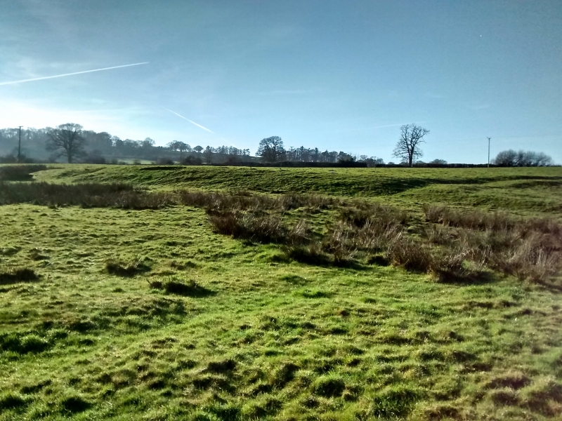
The monument includes a medieval settlement located to the east of Knight
House Farm, Cudworth. The site is linear in plan and is located in Higher
Broad Field on a gentle east and south facing slope adjacent to the west bank
of Wall Brook. The settlement includes earthworks indicating the site of
village features such as houses, small fields or paddocks, a network of
streets and tracks and an area of medieval cultivation.
A hollow way up to 6m wide, indicating a village street, crosses the site from
east to west along which are located several house platforms. Evidence of
medieval agriculture survives at the centre of the settlement where traces of
ridge and furrow are visible within a rectangular field, defined by a shallow
ditch to the north and south. Two more house platforms, and possibly a third,
are located to the north of the ridge and furrow and south of the present
road. These are connected to the village street by two tracks which pass
either side of the ridge and furrow. The track to the east runs parallel with
Wall Brook between the field of ridge and furrow and the river's flood plain.
Several small fields or paddocks defined by low banks, are located to the east
and north of the area of cultivation.
Cudworth is mentioned in the Domesday survey of 1086, where it is recorded
that the site was established before 1066. The settlement is also mentioned in
14th century documents and it lies just to the east of a medieval moated site
and the Church of St Michael.
All fence posts and telegraph poles are excluded from the scheduling, although
the ground beneath them is included.
MAP EXTRACT
The site of the monument is shown on the attached map extract.
Source: Historic England
Medieval rural settlements in England were marked by great regional diversity
in form, size and type, and the protection of their archaeological remains
needs to take these differences into account. To do this, England has been
divided into three broad Provinces on the basis of each area's distinctive
mixture of nucleated and dispersed settlements. These can be further divided
into sub-Provinces and local regions, possessing characteristics which have
gradually evolved during the past 1500 years or more.
This monument lies in the extensive south-west Peninsula sub-Province of the
Northern and Western Province, an area climatically, culturally and physically
distinct from the rest of England. It includes varying terrains, from the
granite uplands, through rolling dissected plateaux to fertile clay lowlands
in the east. Nucleated settlements are present, notably in the Devon
Lowlands and throughout the South Hams. Many of these originated as small
towns, whilst a high proportion may be late foundations. Excluding only the
moorland masses, the sub-Province is characterised by medium and high
densities of dispersed settlements; indeed, some of the former industrial
areas had densities as high as any in the country.
The Axe Valley local region is characterised by having comparatively few
village settlements and high densities of scattered farmsteads. Intricate
terrains are associated with hedged enclosures, woodland patches and a complex
network and roads and paths, many of which are cut deeply into the land as
hollow ways.
Many medieval settlements, such as this one at Cudworth, were organised
agricultural communities, sited at the centre of a parish or township, that
shared resources such as arable land, meadow and woodland. Their plans varied
enormously, but when they survive as earthworks their most distinguishing
features include roads and minor tracks, platforms on which stood houses and
other buildings such as barns, enclosed crofts and small enclosed paddocks.
They frequently included the parish church within their boundaries, and as
part of the manorial system most examples included one or more manorial
centres which may also survive as visible remains as well as below ground
deposits.
The medieval settlement at Cudworth survives well and will contain
archaeological deposits and environmental evidence relating to the settlement
and the landscape in which it was constructed. It is listed in the Domesday
survey and there are contemporary documents relating to the medieval
settlement and to the moated site and church located nearby.
Source: Historic England
Other
Somerset County Council SMR,
Source: Historic England
Other nearby scheduled monuments