Approximate Location Map
Large Map »
This site is entirely user-supported. See how you can help.
If Google Street View is available, the image is from the best available vantage point looking, if possible, towards the location of the monument. Where it is not available, the satellite view is shown instead.
Latitude: 52.8308 / 52°49'50"N
Longitude: -2.8312 / 2°49'52"W
OS Eastings: 344096.121089
OS Northings: 326240.862752
OS Grid: SJ440262
Mapcode National: GBR 7D.TNSW
Mapcode Global: WH8B6.H31P
Entry Name: Bowl barrow 60m south east of Petton parish church
Scheduled Date: 7 June 1971
Last Amended: 7 July 1999
Source: Historic England
Source ID: 1016826
English Heritage Legacy ID: 32299
County: Shropshire
Civil Parish: Petton
Traditional County: Shropshire
Lieutenancy Area (Ceremonial County): Shropshire
Church of England Parish: Petton
Church of England Diocese: Lichfield
The monument includes the earthwork and buried remains of a Bronze Age bowl
barrow, situated on a gentle east facing slope with the ground also falling
away to the south east. From this location there are extensive views of the
surrounding countryside. Approximately 300m north east of the barrow is a
moated site which is the subject of a separate scheduling.
The barrow mound is constructed of sand and gravel. It is about 23m in
diameter and survives to a height of 2m. Although no longer visible at ground
level, a ditch from which material was quarried during the construction of
the monument, surrounds part of the mound. This has become infilled over the
years and survives as a buried feature, approximately 3m wide.
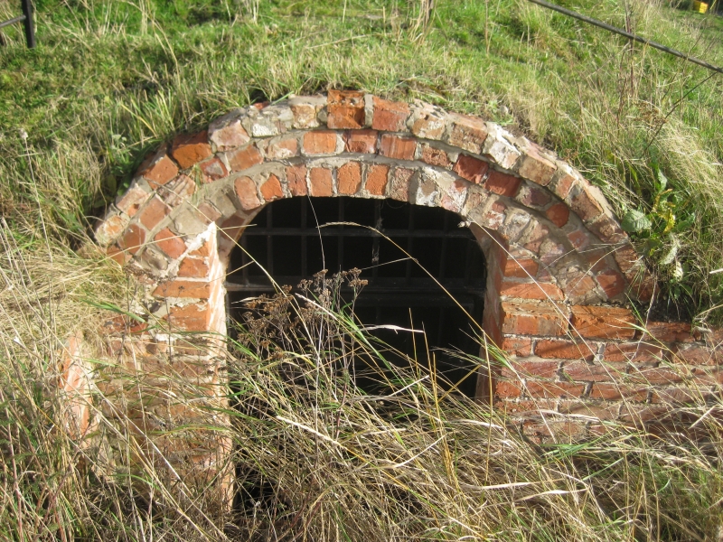
Next to the barrow on its southern side there is an ice house, which is Listed
Grade II. This structure has cut through the ditch surrounding the barrow
mound on this side and is not included in the scheduling. A former sand and
gravel quarry, immediately to the east of the barrow and the ice house, has
also truncated the ditch surrounding the barrow mound and this area is also
not included in the scheduling, although the quarry face is included.
The fence separating the monument from the quarry is excluded from the
scheduling, although the ground beneath it is included.
MAP EXTRACT
The site of the monument is shown on the attached map extract.
Source: Historic England
Bowl barrows, the most numerous form of round barrow, are funerary monuments
dating from the Late Neolithic period to the Late Bronze Age, with most
examples belonging to the period 2400-1500 BC. They were constructed as
earthen or rubble mounds, sometimes ditched, which covered single or multiple
burials. They occur either in isolation or grouped as cemeteries and often
acted as a focus for burials in later periods. Often superficially similar,
although differing widely in size, they exhibit regional variations in form
and a diversity of burial practices. There are over 10,000 surviving bowl
barrows recorded nationally (many more have already been destroyed), occurring
across most of lowland Britain. Often occupying prominent locations, they are
a major historic element in the modern landscape and their considerable
variation of form and longevity as a monument type provide important
information on the diversity of beliefs and social organisations amongst early
prehistoric communities. They are particularly representative of their period
and a substantial proportion of surviving examples are considered worthy of
protection.
Despite later intrusions the bowl barrow 60m south east of Petton parish
church is a well-preserved example of this class of monument. The barrow mound
will retain evidence for its method of construction as well as the burial or
burials within it. These remains will advance our understanding of Bronze Age
society, including the ritual practices and technical abilites of these
people. The accumulated ditch fills will preserve environmental evidence for
the activities which took place at the site during the construction of the
barrow, and its subsequent use. In addition the buried ground surface beneath
the mound will preserve evidence for the prehistoric landscape in which the
barrow was built. The monument now occupies a prominent position in the
landscape.
Source: Historic England
Other nearby scheduled monuments