Approximate Location Map
Large Map »
This site is entirely user-supported. See how you can help.
If Google Street View is available, the image is from the best available vantage point looking, if possible, towards the location of the monument. Where it is not available, the satellite view is shown instead.
Latitude: 53.3896 / 53°23'22"N
Longitude: -3.0115 / 3°0'41"W
OS Eastings: 332828.632427
OS Northings: 388558.199205
OS Grid: SJ328885
Mapcode National: GBR 7YD7.TN
Mapcode Global: WH87D.Q259
Entry Name: Birkenhead Priory
Scheduled Date: 23 April 1979
Last Amended: 18 July 2000
Source: Historic England
Source ID: 1019159
English Heritage Legacy ID: 32571
County: Wirral
Electoral Ward/Division: Birkenhead and Tranmere
Built-Up Area: Birkenhead
Traditional County: Cheshire
Lieutenancy Area (Ceremonial County): Merseyside
Church of England Parish: Birkenhead Christ the King
Church of England Diocese: Chester
The monument includes the ruined and buried remains of part of the 12th
century priory together with the ruins and restored tower of the parish church
of St Mary.
The priory was founded around 1150 by Hamo de Massey of Dunham Massey in
Cheshire. The monks followed the Benedictine rule. It was sited on an isolated
headland in Wirral and bounded by Wallasey Pool on the north side, the Mersey
estuary on the east side and Tranmere Pool on the south side. The monastery
owned lands in what is now Birkenhead and had the use of pasture in Bidston,
Moreton, Claughton, Saughall and Tranmere. They also claimed rights of fishing
and retrieving wreckage in the Mersey. This was a small priory housing only 16
monks at its foundation. However the priory was visited twice by Edward I
during his campaign against the Welsh in 1275 and again in 1277. After the
Dissolution the estate finally passed into the hands of Ralph Worsley of
Lancashire. The buildings fell into ruin with only the chapter house chapel
surviving as a local centre of worship. This was superseded by the building of
the parish church of St Mary in 1821.
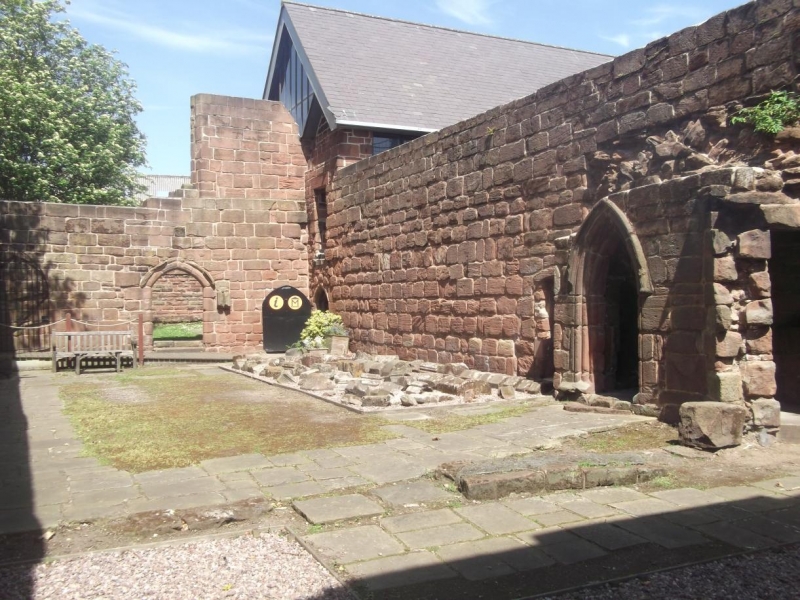
The present ruins include the cloister, surrounded by and linking the chapter
house, scriptorium, the priory church, the western range, the frater range and
the dorter range.
The cloister was started in 1150 and was extended and improved until the 14th
century. The covered alleys have now disappeared but the extent of the
internal garden is still traceable as an earthwork feature. The former chapter
house, which is Listed Grade II*, retains much of its 12th century and later
medieval fabric, despite restoration in the early 20th century; it remains in
ecclesiastical use, and consequently the building is excluded from the
scheduling as it is appropriately managed through its Listing status. The
priory church has been largely demolished on the south eastern side of the
cloister. This replaced an earlier building and was constructed c.1250. Only
two sections of stonework on the west side of the church survive as part
of the ruins but the buried foundations of the bulk of this church will
survive in the area of protection. The west side of the original chancel lies
beneath the present remains of St Mary's Church but the east side of the nave
has been destroyed within the boundary of the shipyard to the south of the
site.
The west range probably housed a guest hall, monk's parlour and prior's
lodgings. It is now a shell and has lost its floor and roof together with the
dividing walls. The frater range, on the northern side of the cloister,
contained the buttery and refectory with a guest room attached to the buttery.
The dorter range to the east of the cloister was built before 1250, housing
the dormitory and latrines for the inmates and included an infirmary. Little
remains of these buildings, and the ground on which they stood was used as a
burial ground for many years.
The parish church of St Mary used to stand to the east of the complex. It was
built in 1821 by Thomas Rickman and made redundant in 1975. Parts have been
demolished as a safety measure and only the refurbished tower and the two
flanking walls with their cast iron window traceries remain. The remains of
the church are included as they are an important element of the later history
of the site.
The ruined priory buildings are Listed Grade I, and the remains of the Church
of St Mary are Listed Grade II.
The former chapter house, the surfaces of paths and parking areas are excluded
from the scheduling, although the ground beneath these features is included.
MAP EXTRACT
The site of the monument is shown on the attached map extract.
Source: Historic England
From the time of St Augustine's mission to re-establish Christianity in AD 597
to the reign of Henry VIII, monasticism formed an important facet of both
religious and secular life in the British Isles. Settlements of religious
communities, including monasteries, were built to house communities of monks,
canons (priests), and sometimes lay-brothers, living a common life of
religious observance under some form of systematic discipline. It is estimated
from documentary evidence that over 700 monasteries were founded in England.
These ranged in size from major communities with several hundred members to
tiny establishments with a handful of brethren. They belonged to a wide
variety of different religious orders, each with its own philosophy. As a
result, they vary considerably in the detail of their appearance and layout,
although all possess the basic elements of church, domestic accommodation for
the community, and work buildings. Monasteries were inextricably woven into
the fabric of medieval society, acting not only as centres of worship,
learning and charity, but also, because of the vast landholdings of some
orders, as centres of immense wealth and political influence. They were
established in all parts of England, some in towns and others in the remotest
of areas. Many monasteries acted as the foci of wide networks including parish
churches, almshouses, hospitals, farming estates and tenant villages.
Benedictine monasticism had its roots in the rule written about AD 530 by St
Benedict of Nursia for his own abbey at Monte Cassino. Benedict had not
intended to establish an order of monasteries and wider adoption of his rule
came only gradually. The first real attempt to form a Benedictine order came
only in 1216. The Benedictine monks, who wore dark robes, came to be known as
`black monks'. These dark robes distinguished them from Cistercian monks who
became known as `white monks' on account of their light coloured robes. Over
150 Benedictine monasteries were founded in England. As members of a highly
successful order many Benedictine houses became extremely wealthy and
influential. Their wealth can frequently be seen in the scale and flamboyance
of their buildings. Benedictine monasteries made a major contribution to many
facets of medieval life and all examples exhibiting significant surviving
archaeological remains are worthy of protection.
Few remains of the original priory at Birkenhead survive but they represent a
core area of the former monastery. They will retain important information
about the development of the complex, its history and functions both in the
standing ruined buildings and in the below ground remains. The survival in its
present location is also remarkable and must be due to the presence of the
1821 parish church on the east side of the site. The site is historically
important because of the 13th century visits by Edward I in order to launch
his campaigns in Wales. These visits show the political importance of the
priory, being situated so close to the Welsh marches at that period, even
though the complex was relatively small.
Source: Historic England
Books and journals
Croasdale, C, Birkenhead Priory, (1994)
Knowles, D , Medieval Religious Houses: England and Wales, (1971), 59
Pevsner, N, Hubbard, E, The Buildings of England: Cheshire, (1971), 81
Source: Historic England
Other nearby scheduled monuments