Approximate Location Map
Large Map »
This site is entirely user-supported. See how you can help.
If Google Street View is available, the image is from the best available vantage point looking, if possible, towards the location of the monument. Where it is not available, the satellite view is shown instead.
Latitude: 53.6835 / 53°41'0"N
Longitude: -0.6697 / 0°40'11"W
OS Eastings: 487954.580611
OS Northings: 421605.570357
OS Grid: SE879216
Mapcode National: GBR RTRV.S9
Mapcode Global: WHGFS.PP80
Entry Name: Countess Close moated site
Scheduled Date: 23 February 1971
Last Amended: 16 April 1999
Source: Historic England
Source ID: 1017289
English Heritage Legacy ID: 32622
County: North Lincolnshire
Civil Parish: Alkborough
Built-Up Area: Alkborough
Traditional County: Lincolnshire
Lieutenancy Area (Ceremonial County): Lincolnshire
Church of England Parish: Alkborough St John the Baptist
Church of England Diocese: Lincoln
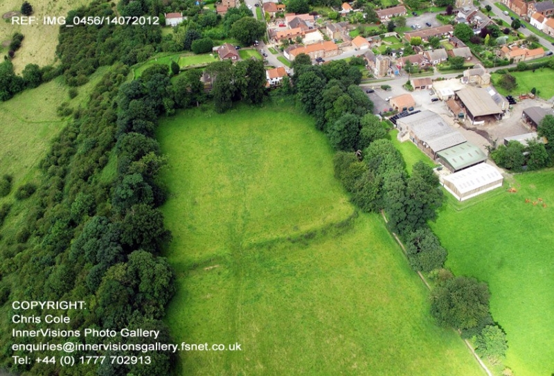
The monument includes the buried and earthwork remains of a fortified medieval
manor house located at the top of the scarp above the River Trent floodplain
on the south western edge of Alkborough.
Antiquarians from Abraham de la Pryme in the 17th century onwards thought that
Countess Close was a Roman fortification. Small scale excavations in 1879
failed to find evidence of Roman occupation, but uncovered arch stones and
pottery now thought to have been medieval. Stray finds of pottery found since
confirm the medieval dating of the monument. Countess Close is thought to owe
its name to a Saxon heiress, Lucy, who was countess in her own right of
Leicester, Lincoln and Chester and is thought to have been the daughter of
William Mallet, recorded as the main land owner in Alkborough by the Domesday
Book. She married Ivo Taillebois, nephew of William the Conqueror, who was
Peterborough Abbey's tenant at Walcott and who was given land in Alkborough by
the abbey sometime before his death in 1104. Countess Lucy went on to remarry
twice, with her manor in Alkborough passing to the son of her second husband
who in turn gave property to Spalding Priory. In 1147 a chapel was built
following the arbitration of a dispute between Spalding Priory and
Peterborough Abbey. It is thought that this chapel was built in or near to
Countess Close.
The monument includes a main enclosure, defined by a bank and external moat
ditch, with an annex or second enclosure on the south western side. The moat
ditches were almost certainly dry moats and never water filled. The whole
monument is aligned with the edge of the 30m high steep scarp above the
floodplain of the Trent. The bank and ditch between the main enclosure and the
annex were levelled in 1965-6, but their position can be seen as soil marks
and the course of the moat ditch is marked by a slight depression. The north
eastern side is the best preserved section of bank and ditch. Here the moat
ditch is up to 1.5m deep and measures up to 15m wide from the top of the
internal bank to the outer lip of the ditch. The internal bank runs
immediately alongside the ditch and stands up to 3m above its base, 1.5m above
the interior of the enclosure. On the north western side, the level of the
interior rises so that there is only a slight bank when viewed from inside the
enclosure. From the outside it appears to be up to 3m high with the moat ditch
continuing with a low external bank separating it from the steep scarp. The
level of the annex is generally about 0.2m-0.3m below that of the main
enclosure. It has a moat ditch on its north western side up to 2.5m deep and
6m-8m wide with a 1m high bank defining its north western side before the edge
of the scarp. On the western side of the annex there is a slightly raised
level area which is considered to have been a building platform for a range of
buildings. In the eastern part of the annex there is a broad depression which
is characteristic of areas used for holding livestock. The main enclosure,
which measures approximately 80m by 90m internally, also has a level raised
area on the western side. This is considered to be the building platform for
the main hall and associated buildings, possibly including the chapel built in
1147. The stonework found in 1879 came from the south western corner of the
main enclosure. On the eastern side the ground is quite stony, which may
indicate further building remains or yard surfaces.
The telegraph pole near Vicarage Lane, all modern fencing and sign posts are
excluded from the scheduling, although the ground beneath is included.
MAP EXTRACT
The site of the monument is shown on the attached map extract.
Source: Historic England
Around 6,000 moated sites are known in England. They consist of wide ditches,
often or seasonally water-filled, partly or completely enclosing one or more
islands of dry ground on which stood domestic or religious buildings. In some
cases the islands were used for horticulture. The majority of moated sites
served as prestigious aristocratic and seigneurial residences with the
provision of a moat intended as a status symbol rather than a practical
military defence. The peak period during which moated sites were built was
between about 1250 and 1350 and by far the greatest concentration lies in
central and eastern parts of England. However, moated sites were built
throughout the medieval period, are widely scattered throughout England and
exhibit a high level of diversity in their forms and sizes. They form a
significant class of medieval monument and are important for the understanding
of the distribution of wealth and status in the countryside. Many examples
provide conditions favourable to the survival of organic remains.
Countess Close includes substantial upstanding medieval earthworks and will
retain additional buried remains including building foundations, rubbish pits,
and evidence of both agricultural and small scale industrial activity. Its
historical association with Countess Lucy implies that it is an early example
of a moated site. The monument's importance is further enhanced by its
proximity to Julian's Bower, a rare survival of a medieval turf maze and the
subject of a separate scheduling.
Source: Historic England
Other
Record Card, North Lincolnshire SMR, 44,
Source: Historic England
Other nearby scheduled monuments