Approximate Location Map
Large Map »
This site is entirely user-supported. See how you can help.
If Google Street View is available, the image is from the best available vantage point looking, if possible, towards the location of the monument. Where it is not available, the satellite view is shown instead.
Latitude: 54.389 / 54°23'20"N
Longitude: -0.9564 / 0°57'23"W
OS Eastings: 467862.941226
OS Northings: 499784.567
OS Grid: SE678997
Mapcode National: GBR PKRP.QF
Mapcode Global: WHF91.8YS5
Entry Name: Blakey Howe round barrow
Scheduled Date: 27 February 1963
Last Amended: 3 July 2000
Source: Historic England
Source ID: 1018983
English Heritage Legacy ID: 32642
County: North Yorkshire
Civil Parish: Farndale East
Traditional County: Yorkshire
Lieutenancy Area (Ceremonial County): North Yorkshire
Church of England Parish: Kirkbymoorside All Saints
Church of England Diocese: York
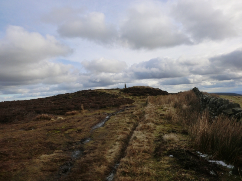
The monument includes buried and earthwork remains of a prehistoric burial
mound, also known as Cockpit Hill, which is topped by an 18th century boundary
stone. It is located 80m NNW of the Lion Inn, marked on the 1:10,000 map as
Blakey House, just to the west of the Castleton to Hutton-le-Hole road. It
survives in an area extensively worked for coal in the post-medieval period,
an activity which has left behind numerous spoil heaps along the ridge.
Referred to as Blakenhow in a Charter of Guisborough Priory in 1200, the round
barrow is prominently sited on a natural rise on the spine of Blakey Ridge and
is intervisible with a number of other prominently located barrows in the
area. Constructed of earth with some stone, it is just over 20m in diameter
and stands 2m high with an old antiquarian excavation hollow 6m in diameter
and up to 1.5m deep in its top. This hollow is thought to have been used for
staging cockfights, explaining the barrow's alternative name. On the rim of
this hollow, on the southern side, there is a 0.25m square and 1.4m high
boundary stone which tapers towards its top. On its west face it is inscribed
with the initials TD above four more weathered characters. This is taken to
refer to Thomas Duncombe who owned the Duncombe Estate in the early 18th
century. It is possible that this stone, which is Listed Grade II, may be a
redressed and reset prehistoric standing stone.
Although there is no ditch visible around the barrow, a 3m margin around the
mound has been included to allow for its likely survival. This is because
excavations of other examples in the region have shown that, even where no
encircling depression is discernible on the modern ground surface, ditches
immediately around the outside of the mound frequently survive as infilled
features, containing additional archaeological deposits. The barrow is
respected by a drystone wall which skirts it to the west and a small roadstone
quarry to the east, neither of which are included in the scheduling.
MAP EXTRACT
The site of the monument is shown on the attached map extract.
It includes a 2 metre boundary around the archaeological features,
considered to be essential for the monument's support and preservation.
Source: Historic England
Round barrows are funerary monuments dating from the Late Neolithic period to
the Late Bronze Age, with most examples belonging to the period 2400-1500 BC.
They were constructed as earthen mounds, sometimes ditched, which covered
single or multiple burials. They occur either in isolation or grouped as
cemeteries and often acted as a focus of burials in later periods. Often
superficially similar, although differing widely in size, they exhibit
regional variations in form and a diversity of burial practices. There are
over 10,000 surviving examples recorded nationally (many more have already
been destroyed), occurring across most of Britain, including the Wessex area
where it is often possible to classify them more closely, for example as bowl
or bell barrows. Often occupying prominent locations, they are a major
historic element in the modern landscape and their considerable variation in
form and longevity as a monument type provide important information on the
diversity of beliefs and social organisations amongst early prehistoric
communities. They are particularly representative of their period and a
substantial proportion of surviving examples are considered worthy of
protection.
Excavations of round barrows in the region have shown that they demonstrate a
wide range of burial rites, from simple scatters of cremated material to
coffin inhumations and cremations contained in urns, typically dating to the
Bronze Age. A common factor is that barrows were normally used for more than
one burial and that the primary burial was frequently on or below the original
ground surface, often with secondary burials located within the body of the
mound. In the Bronze Age, many round barrows are thought to have acted as
territorial markers in addition to their role as burial sites. Blakey Howe,
placed on the spine of Blakey Ridge, is considered to be one such example.
This function has continued, as shown by the inscribed boundary stone, and the
barrow now marks a parish boundary.
Blakey Howe is a relatively well preserved round barrow, despite the
disturbance by antiquarian excavation, and will retain important
archaeological information. The boundary stone, a good 18th century example
possibly reusing a prehistoric standing stone, adds additional interest.
Source: Historic England
Other nearby scheduled monuments