Approximate Location Map
Large Map »
This site is entirely user-supported. See how you can help.
If Google Street View is available, the image is from the best available vantage point looking, if possible, towards the location of the monument. Where it is not available, the satellite view is shown instead.
Latitude: 54.3729 / 54°22'22"N
Longitude: -0.9441 / 0°56'38"W
OS Eastings: 468692.773037
OS Northings: 497998.830001
OS Grid: SE686979
Mapcode National: GBR PKVW.D6
Mapcode Global: WHF97.GCN0
Entry Name: Kettle Howe round cairn
Scheduled Date: 20 June 1967
Last Amended: 3 July 2000
Source: Historic England
Source ID: 1018985
English Heritage Legacy ID: 32644
County: North Yorkshire
Civil Parish: Farndale East
Traditional County: Yorkshire
Lieutenancy Area (Ceremonial County): North Yorkshire
Church of England Parish: Lastingham St Mary
Church of England Diocese: York
The monument includes buried and earthwork remains of a prehistoric burial
mound which is topped by an 18th century boundary stone. It is located 250m
east of the Castleton to Hutton-le-Hole road. It survives in an area
extensively worked for coal in the post-medieval period, an activity which has
left behind numerous spoil heaps.
The round cairn is sited on the northern edge of a flat plateau which forms a
high point on Blakey Ridge. It is prominently located and is intervisible with
Blakey Howe and Little Blakey Howe to the north and with Pike Howe and other
burial mounds to the south. It is up to 8m in diameter and 0.6m high, mainly
constructed of stone. These stones vary considerably in size, most being up to
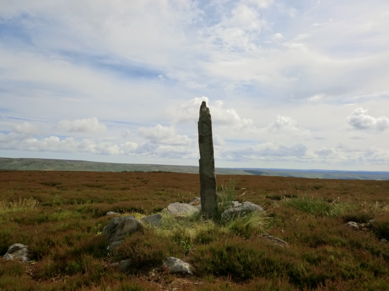
0.2 across, but with several 0.4m to 0.7m across. On top of the cairn, on its
northern side, there is a roughly shaped boundary stone 0.3m by 0.2m, standing
1.5m tall, with its larger faces directed north and south. The initial T is
inscribed on the north face and D on the west face. This is thought to refer
to Thomas Duncombe who owned the Duncombe Estate in the early 18th century.
This stone may be a reused prehistoric standing stone associated with the
round cairn.
Although there is no ditch visible around the cairn, a margin of 3m
surrounding the mound is included to allow for its likely survival. This is
because excavations of other examples in the region have shown that, even
where no encircling depression is discernible on the modern ground surface,
ditches immediately around the outside of the mound frequently survive as
infilled features, containing additional archaeological deposits.
MAP EXTRACT
The site of the monument is shown on the attached map extract.
It includes a 2 metre boundary around the archaeological features,
considered to be essential for the monument's support and preservation.
Source: Historic England
Round cairns are prehistoric funerary monuments dating to the Bronze Age
(c.2000-700 BC). They were constructed as stone mounds covering single or
multiple burials. These burials may be placed within the mound in stone-lined
compartments called cists. In some cases the cairn was surrounded by a ditch.
Often occupying prominent locations, cairns are a major visual element in the
modern landscape. They are a relatively common feature of the uplands and are
the stone equivalent of the earthen round barrows of the lowlands. Their
considerable variation in form and longevity as a monument type provide
important information on the diversity of beliefs and social organisation
amongst early prehistoric communities. They are particularly representative of
their period and a substantial proportion of surviving examples are considered
worthy of protection.
Excavation of round cairns and their earthen equivalents, round barrows, in
the region have shown that they demonstrate a very wide range of burial rites
from simple scatters of cremated material to coffin inhumations and cremations
contained in urns, typically dating to the Bronze Age. A common factor is that
they were normally used for more than one burial and that the primary burial
was frequently on or below the original ground surface, often with secondary
burials located within the body of the mound. In the Bronze Age, many cairns
and barrows are thought to have acted as territorial markers in addition to
their role as burial sites. Kettle Howe, placed on the spine of Blakey Ridge,
is considered to be one such example. This function has continued, as shown by
the inscribed boundary stone, and the barrow now marks a parish boundary.
Kettle Howe is a good, well preserved example of a small round cairn. The
boundary stone, a good 18th century example possibly reusing a prehistoric
standing stone, adds additional interest.
Source: Historic England
Other nearby scheduled monuments