Approximate Location Map
Large Map »
This site is entirely user-supported. See how you can help.
If Google Street View is available, the image is from the best available vantage point looking, if possible, towards the location of the monument. Where it is not available, the satellite view is shown instead.
Latitude: 54.3563 / 54°21'22"N
Longitude: -0.9367 / 0°56'11"W
OS Eastings: 469202.873504
OS Northings: 496162.0645
OS Grid: SE692961
Mapcode National: GBR PLX2.04
Mapcode Global: WHF97.LR5R
Entry Name: Pike Howe round cairn
Scheduled Date: 10 June 1975
Last Amended: 3 July 2000
Source: Historic England
Source ID: 1018986
English Heritage Legacy ID: 32645
County: North Yorkshire
Civil Parish: Rosedale West Side
Traditional County: Yorkshire
Lieutenancy Area (Ceremonial County): North Yorkshire
Church of England Parish: Kirkbymoorside All Saints
Church of England Diocese: York
The monument includes buried and earthwork remains of a prehistoric burial
mound, topped by a more recent stone cairn which is also included in the
scheduling. It is located 230m to the east of the Castleton to Hutton-le-Hole
road, adjacent to a footpath crossing Blakey Ridge.
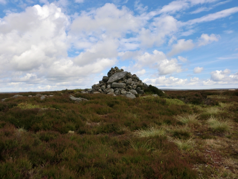
The round cairn is sited on the centre line of Blakey Ridge, which at this
point is a plateau about 600m east-west, gently sloping southwards. It is
intervisible with burial mounds to the north along the ridge, as well as with
the barrow group known as Three Howes to the south east. The cairn, which is
constructed of stone and earth, is 12m in diameter and up to 0.9m high. On its
eastern side there is a 1.4m high modern cairn which includes a flat slab 1m
by 0.6m near its base. Although there is no ditch visible around the cairn,
a 3m margin surrounding the mound is included to allow for its likely
survival. This is because excavations of other examples in the region have
shown that, even where no encircling depression is discernible on the modern
ground surface, ditches immediately around the outside of the mound frequently
survive as infilled features, containing additional archaeological deposits.
MAP EXTRACT
The site of the monument is shown on the attached map extract.
It includes a 2 metre boundary around the archaeological features,
considered to be essential for the monument's support and preservation.
Source: Historic England
Round cairns are prehistoric funerary monuments dating to the Bronze Age
(c.2000-700 BC). They were constructed as stone mounds covering single or
multiple burials. These burials may be placed within the mound in stone-lined
compartments called cists. In some cases the cairn was surrounded by a ditch.
Often occupying prominent locations, cairns are a major visual element in the
modern landscape. They are a relatively common feature of the uplands and are
the stone equivalent of the earthen round barrows of the lowlands. Their
considerable variation in form and longevity as a monument type provide
important information on the diversity of beliefs and social organisation
amongst early prehistoric communities. They are particularly representative of
their period and a substantial proportion of surviving examples are considered
worthy of protection.
Excavations of round cairns and their earthen equivalents, round barrows, in
the region have shown that they demonstrate a very wide range of burial rites
from simple scatters of cremated material to coffin inhumations and cremations
contained in urns, typically dating to the Bronze Age. A common factor is that
they were normally used for more than one burial and that the primary burial
was frequently on or below the original ground surface, often with secondary
burials located within the body of the mound. In the Bronze Age, many cairns
and barrows are thought to have acted as territorial markers in addition to
their role as burial sites. Pike Howe, placed on the centre line of Blakey
Ridge, is considered to be one such example. This function has continued, as
shown by the more recent cairn which marks the boundary between two parishes
and estates.
Pike Howe is a good example of a round cairn which has been little disturbed.
Source: Historic England
Other nearby scheduled monuments