Approximate Location Map
Large Map »
This site is entirely user-supported. See how you can help.
If Google Street View is available, the image is from the best available vantage point looking, if possible, towards the location of the monument. Where it is not available, the satellite view is shown instead.
Latitude: 54.341 / 54°20'27"N
Longitude: -0.8805 / 0°52'49"W
OS Eastings: 472879.6902
OS Northings: 494513.7034
OS Grid: SE728945
Mapcode National: GBR QL97.5N
Mapcode Global: WHF9G.F4YZ
Entry Name: Hollins Mine and Bank Top iron calcining kilns
Scheduled Date: 2 November 1999
Source: Historic England
Source ID: 1018982
English Heritage Legacy ID: 32661
County: North Yorkshire
Civil Parish: Hartoft
Traditional County: Yorkshire
Lieutenancy Area (Ceremonial County): North Yorkshire
Church of England Parish: Lastingham St Mary
Church of England Diocese: York
The monument includes standing, buried and earthwork remains of a mid-19th
century iron mining complex located on the western side of Rosedale,
approximately 1km south of the village of Rosedale Abbey. It includes the Bank
Top iron calcining kilns (which are Listed Grade II), with their associated
tips and other features, the remains of Hollins Mine which was the main source
of the ore for the kilns and the 900m long incline which linked the mine to
the kilns. The monument is a core part of Rosedale's wider iron mining
landscape and further 19th century industrial remains lie beyond the area of
protection.
The iron mines of Rosedale were a fringe area of the important Cleveland iron
ore field, in which the ore mostly occurs as horizontally bedded Jurassic
ironstone, typically as a thick seamed but relatively low grade ore. Apart
from small scale medieval surface workings, Cleveland iron ore was first
exploited in the 1830s, peaked at 6 million tons in 1883, a third of Britain's
output, and declined after World War One to end in 1964. The ore field was
very important economically and helped to make Middlesbrough the centre of the
international iron market in the late 19th century. At first the iron ore was
typically worked by quarrying the outcrops, then by mining via drifts driven
into the face, the thick seams often requiring no extraction of waste rock.
This has left extensive, generally linear areas of remains including working
faces, tramways, engine houses, and relatively small waste tips compared to
other mining sites.
In Rosedale in 1853 magnetite ore, a high grade iron ore, was discovered just
north east of Hollins Farm. This and later discoveries of lower grade
carbonate iron ore resulted in the establishment of a series of iron mines
around the dale linked by branch lines of the North Eastern Railway. Hollins
was the first mine to be established with leases secured in 1856 and 1857 to
exploit the magnetite which formed two troughs up to 22m thick, extending over
400m into the dale side. The area was worked intensively from 1859 by the
Rosedale Mining Company, with 3,000-4,000 tons of ore initially transported to
the railway at Pickering using horses. In January 1861 a narrow gauge incline
started operation, linking the mine to Bank Top and the terminus of the
Rosedale West branch line which opened at the end of March. This improved
transport link allowed the rapid expansion of mining operations with over
200,000 tons being produced in 1862. The deposits of magnetite were quickly
worked out, but mining continued, exploiting larger reserves of lower grade
carbonate ore. To concentrate this ore, lowering its mass and increasing its
value, calcining kilns were constructed at Bank Top. Production at the mines,
including the smaller scale workings to the north, peaked at 560,000 tons in
1873, but a slump in the iron trade and a strike in 1874 saw a rapid decline
in output and the collapse of the Rosedale and Ferryhill Iron Company in March
1879. Mining, by the Carlton Iron Company, resumed at a much lower level in
1881 until 1885 when Hollins Mine became the first of the Victorian Rosedale
mines to close.
The remains of Hollins Mine lies at the eastern end of the monument and is
formed by two large openworkings extending into the dale side. These
correspond to the two deposits of magnetite which were exploited initially. In
the base of these workings there is a series of collapsed drift entrances
which were opened to extract the more extensive deposits of carbonate ore.
Tramways lead out north eastwards from these drift entrances onto a terraced
area with spoil heaps extending downhill to the north east. The tramways
curved around north westwards to meet the foot of the incline to Bank Top.
Between the drifts and the incline there is an area of spoil heaps which
retains the cutting for an earlier alignment of the incline as well as the
base of a ventilation chimney around the top of an airshaft. The incline runs
uphill, across the line of the slope, initially curving west to WNW for 150m
and then continuing straight for 750m to end at Bank Top above and to the west
of the calcining kilns. The incline, which was single tracked, is between 2.2m
and 5.2m wide and along most of its length is formed by an embankment. In
places it has stone built revetments and stone lined culverts. The Rosedale
Chimney Bank road passes over the incline, which at this point is lying in a
cutting, via an embankment. This later embankment is believed to overlay the
surviving remains of a bridge. The incline was powered by a stationary steam
winding engine sited approximately 80m beyond the top end of the incline. The
twin beds for this engine survive as 15m long walls 1.85m wide and 2m apart,
partly obscured by fallen masonry. In the top of each wall there are the
remains of two rows of five pairs of iron rods, originally used to secure the
steam engine to its base. Adjacent to the north there are the ruined remains
of the boiler house represented by turf covered rubble banks in an area 21m by
13m. This originally held three low pressure Collins type boilers, two of
which were transferred to Rosedale East Mines in 1885 with the abandonment of
the incline. On the west side of the boiler house there is a further scatter
of mainly brick masonry which is the remains of the boiler chimney. Centred
70m to the west is an approximately rectangular, water filled reservoir 27m by
25m which supplied the boilers with water. This is defined by low banks up to
1.5m high and fed by a leat which extends north west from the boundary of the
monument for over 700m to reach springs on Shooting House Hill.
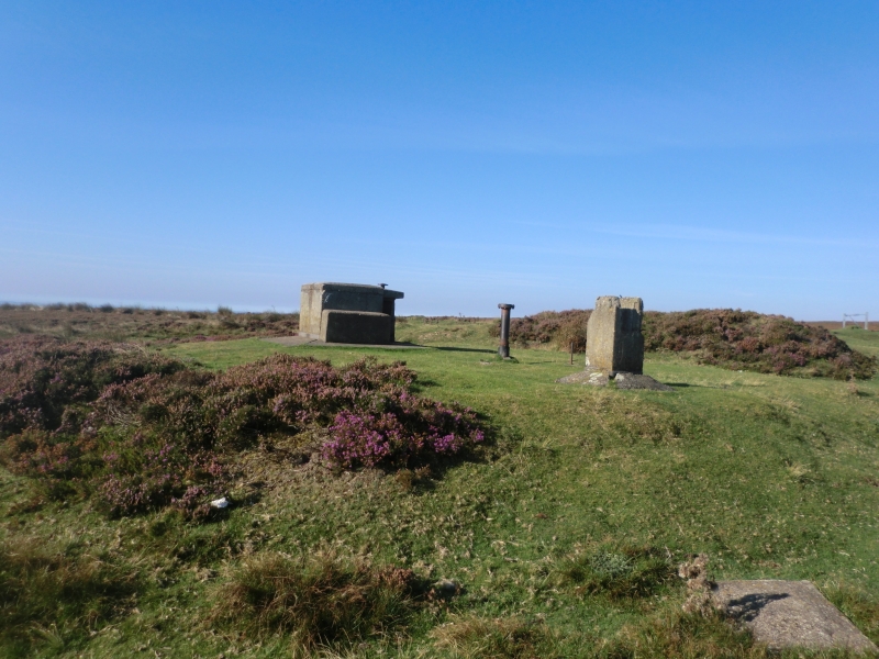
Nearly 200m east of the reservoir are the Bank Top calcining kilns. These form
a massive stone structure including a pair of kilns built into the hillside.
Internally each kiln is roughly elliptical in plan, originally lined with fire
brick, with four arched openings in its eastern wall. The southern kiln was
built first and is the best preserved. It is slightly smaller, the rear wall
being just over 17m long, and its four stone built round headed arches being
slightly narrower than the northern kiln's. The rear wall of the north kiln
has largely collapsed, but it would have been just over 20m long. The kiln's
four semi-circular arches are brick built with a stone facing. The kilns were
loaded with iron ore and coal from above and the calcined ore was drawn out of
the base of the kilns, through the arched openings, and loaded directly into
metal bodied trucks on a siding which ran along the front, east side of the
kilns. Although most sorting of ore from waste rock is thought to have been
conducted at the bottom of the incline, some final sorting also occurred
before loading the kilns resulting in the finger tips of spoil that extend
both to the south and north of the rear of the kilns. The west side of these
spoil tips was constrained by another railway siding which led to a coal depot
shown on the 1893 Ordnance Survey map. The remains of this depot, which is not
thought to have been part of the mine complex, lie beside the road, just
outside the area of protection. Remains of a second coal depot, disused by
1893, are included in the monument. These lie 200m south east of the
reservoir, built into the side of the spoil tips and includes a 64m long coal
bunker with a tramway along its eastern side which heads towards the top of
the calcining kilns. Revetting the opposite side of the spoil tips, 80m to the
east, there is a section of massive stone walling up to 40m long which is
roughly in line with the rear wall of the calcining kilns centred 100m to the
north. This has been interpreted as the remains of a second bank of calcining
kilns which, according to an 1865 poem, was badly designed and collapsed. The
monument also includes the surviving tips of calcine dust that lie to the east
of the calcining kilns.
A number of features are excluded from the scheduling; these are all modern
fences, styles and gates and all road surfaces, although the ground beneath
these features is included.
MAP EXTRACT
The site of the monument is shown on the attached map extract.
It includes a 2 metre boundary around the archaeological features,
considered to be essential for the monument's support and preservation.
Source: Historic England
Iron has been produced in England from at least 500 BC. The iron industry,
spurred on by a succession of technological developments, has played a major
part in the history of the country, its production and overall importance
peaking with the Industrial Revolution. Iron ores occur in a variety of forms
across England, giving rise to several different extraction techniques,
including open casting, seam-based mining similar to coal mining, and
underground quarrying, and resulting in a range of different structures and
features at extraction sites. Ore was originally smelted into iron in small,
relatively low-temperature furnaces known as bloomeries. These were replaced
from the 16th century by blast furnaces which were larger and operated at a
higher temperature to produce molten metal for cast iron. Cast iron is
brittle, and to convert it into malleable wrought iron or steel it needs to be
remelted. This was originally conducted in an open hearth in a finery forge,
but technological developments, especially with steel production, gave rise to
more sophisticated types of furnaces. A comprehensive survey of the iron and
steel industry has been conducted to identify a sample of ten sites of
national importance that represent the industry's chronological range,
technological breadth and regional diversity.
Iron ore occurs in two main chemical forms, as a carbonate and as an oxide.
The carbonate ores require calcining (roasting) to drive off carbon dioxide,
converting the ore into an oxide before it can be smelted to produce iron or
steel. Calcining also improves the ore for smelting by driving off water and
other volatile substances, and by breaking the ore into smaller fragments. The
earliest and simplest method of calcining was to pile ore and fuel into a heap
known as a clamp, and then to set light to it. The sites of clamps can
sometimes be recognised by deposits of gritty red or purple calcine dust, also
known as fines. Although clamps were used into the 20th century in some areas,
they were generally replaced with calcining kilns from the 17th century, as
these were found to require less fuel. Initially similar to lime kilns, they
were typically stone-built structures which were loaded from the top, with the
calcined ore drawn out through an arched opening at the base. In the 19th
century, kiln design developed, employing new materials such as fire-brick and
ironwork. There were two principal forms of kiln. Both operated in a similar
manner, but had different interior shapes. One was rectangular or elliptical
in plan, with an inverted cone-shaped cross section and two or more arched
openings along its base through which the calcined ore was drawn. The second,
known as the Gjers type, was circular in plan, narrowing to both top and
bottom in cross section. Both operated continuously, with ore and fuel loaded
at intervals in the top and the calcined ore drawn out from the bottom.
Calcining frequently took place close to where the ore was smelted, and
sometimes actually at the mine, especially where transportation costs were a
major factor, because calcining both reduced the weight of the ore by between
15 and 50% and increased its value. Because of their ephemeral nature,
evidence of calcining clamps of any date rarely survive. Thus any sites with
confirmed remains in addition to calcine dust are considered to be of national
importance. Kilns are a more common survival, and a representative sample of
better preserved calcining kilns, illustrating the range of different designs,
are considered to merit protection. Those retaining remains of associated
mining and/or smelting complexes are considered to be of particular
importance.
The ironstone mines of the North York Moors and the Cleveland Hills were of
great national economic importance. A sample of the better preserved sites,
including a representative range of extraction techniques and structures, are
considered to merit protection.
Rosedale witnessed an explosion in iron mining in the mid-19th century, its
population increasing from 548 in 1851 to 2839 in 1871. This has left an
extensive industrial landscape across and around Rosedale which is amongst the
best iron mining landscapes known nationally. The monument forms an important
and well preserved core area of this wider landscape. The mining boom started
with the Hollins Mine magnetite deposits. The Bank Top calcining kilns are
also thought to be the earliest of the three sets of kilns within the dale and
are the only ones retaining their associated tips of waste calcine dust. The
incline linking the mine to the kilns forms a striking landscape feature which
also retains remains of its winding house and associated features. The whole
monument forms a well preserved complex which aids our understanding of the
way in which the kilns functioned.
Source: Historic England
Books and journals
Hayes, , Rutter, , 'Research Report' in Rosedale Mines and Railway, , Vol. 9, (1974)
Other
Typescript report, Lane, Paul , Archaeology of the Ironstone Industry of Rosedale, (1989)
Source: Historic England
Other nearby scheduled monuments