Approximate Location Map
Large Map »
This site is entirely user-supported. See how you can help.
If Google Street View is available, the image is from the best available vantage point looking, if possible, towards the location of the monument. Where it is not available, the satellite view is shown instead.
Latitude: 54.0864 / 54°5'10"N
Longitude: -1.0064 / 1°0'23"W
OS Eastings: 465091.602461
OS Northings: 466062.103426
OS Grid: SE650660
Mapcode National: GBR PPD5.XX
Mapcode Global: WHFBK.HKZ5
Entry Name: Sheriff Hutton quadrangular castle and early garden earthworks
Scheduled Date: 30 August 1922
Last Amended: 11 December 2001
Source: Historic England
Source ID: 1019593
English Heritage Legacy ID: 32704
County: North Yorkshire
Civil Parish: Sheriff Hutton
Built-Up Area: Sheriff Hutton
Traditional County: Yorkshire
Lieutenancy Area (Ceremonial County): North Yorkshire
Church of England Parish: Sheriff Hutton St Helen and the Holy Cross
Church of England Diocese: York
The monument includes the standing, buried and earthwork remains of a late
14th century quadrangular castle and associated features including the
earthworks of a 16th century garden. It is prominently located on the southern
side of Sheriff Hutton, overlooking the Vale of York.
John Lord Neville of Raby was granted a licence to build a stone castle in
1382 by Richard II. It is thought that this replaced the earlier earthen
ringwork castle, which lies adjacent to the church 0.5km to the east, and is
the subject of a separate scheduling. From the mid-15th century, Sheriff
Hutton was held by Richard Neville, Earl of Warwick, known as `Warwick the
Kingmaker'. He used Sheriff Hutton, along with Middleham castle, as his
principal bases in the north of England. After his death in 1471 at the Battle
of Barnet, Sheriff Hutton was seized by the crown and granted to Richard Duke
of Gloucester who became Richard III in 1483. From circa 1489 the castle
periodically hosted the Council of the North and in 1525 was granted by
Henry VIII to his illigitimate son Henry Fitzroy, the Duke of Richmond and
Warden-General of the Marches. Used as a seat of provincial government, at
this time the castle had a staff of 142 in addition to the 100 servants in the
Duke's retinue. A survey of the state of the castle found that extensive
repairs were required, but by 1534 John Leyland wrote that there was `no house
in the North so like a princely lodgings'. These two documentary sources
describe how the castle was formed by three courts or wards. The inner court
included the hall, kitchen and the lord's stately lodgings including a chapel.
The middle court was described as being protected by three great towers, the
middle tower forming a gatehouse, but in 1525 this court required extensive
repairs to its walls, a section of which over 20m long had collapsed. The
outer court included a brewhouse, horse mills, stables and barns. A further
series of repairs were made in 1537 when the castle was returned to Henry VIII
following Fitzroy's death. Shortly afterwards, the Council of the North was
moved to York and apart from a further campaign of repairs in 1573-75, the
castle was allowed to decay, with the deliberate removal of roofing lead
towards the end of the century. In 1618-19 James I sold the `ruinous castle of
Sheriff Hutton' to Thomas Lumsden. In 1621 it was bought by Sir Aurthur
Ingram, in whose family it remained until the early 20th century, being used
principally as a source of building materials. The castle is thought to have
been too ruinous to have played any part in the English Civil War and was not
included in the 1649 Parliamentarian survey of castles. There is a 1721
illustration of the north side of the castle and its layout is shown on plans
of the village dated 1765 and 1786. A discussion of the various documentary
and pictorial records of the monument forms part of a 1997 survey report by Ed
Dennison which also describes in detail the surviving standing and earthwork
remains of the monument.
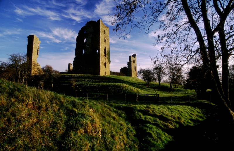
The monument is dominated by the four ruined towers of the castle's inner
court, set at the western end of a natural ridge that stands over 9m above the
land to the west and south. In design the inner court is very similar to
Bolton Castle in Wensleydale which was built in 1379-1396. Parts of the
curtain walls, which linked the four corner towers and include evidence of
the integral building ranges and undercrofts inside them, also survive.
Overall the inner court measures 66m by just over 52m externally, its
long axis orientated NNW to SSE, although the castle is conventionally
described as if it were aligned north-south. Adjacent to the south eastern
tower, forming part of the eastern curtain wall, is the gatehouse which led
out into the middle court. This is thought to have been an early 15th century
addition to the castle and retains a frieze of four heraldic shields dated
after 1402. This gatehouse is one of the features which suggests that the
castle was designed as a high prestige residence with considerations of the
display of wealth and power taking precedence over the needs of defence. The
gatehouse has no provision for a portcullis and could be circumvented by a
ground floor doorway through the southern curtain wall. The south western
tower has the best views over the Vale of York and is thought to have included
the high-status accommodation. It was divided into four floors with barrel-
vaulted basement, ground floor rooms and well lit first and second floors
approximately 6m and 5m high respectively. Each floor had windows in the
southern and western walls, (the castle's external face), and where the
moulding survives, appear to have been typically trefoil headed, often with
twin lights. The other three corner towers are similar in design except that
in place of the two high roofed upper floors there are three less lofty
storeys. There is evidence that ground level chambers within the curtain walls
also had windows facing out of the castle and it is possible that the doorway
through the southern curtain wall was mirrored on the northern and western
walls as well. On the 1765 map of Sheriff Hutton, the inner court was labelled
Far Wards. Adjoining it to the east, there is a second walled enclosure
depicted, which was labelled Fore Wards. This was also approximately
quadrangular, but slightly larger than the inner court, occupying the same
area as the farm buildings for the existing Castle Farm. This court is thought
to have been for lower status accommodation, and probably included servants
quarters and guard barracks as well as some auxiliary rooms such as stores.
Buried evidence for these structures will survive beneath and around the
existing buildings. The outer court is recorded as having a number of
auxiliary buildings such as stables and a brewhouse, and is believed to have
occupied the area between the middle court and the medieval market place to
the east, which now survives as a village green. The area to the north and
east of Castle Farm's farmhouse retains a number of low earthworks, some of
which are interpreted as the buried remains of features in the outer court.
The castle is a Listed Building Grade II*
To the south and west of the castle there are extensive earthwork remains of
an impressive landscaped garden which is believed to have been created for
Henry Fitzroy in the early 16th century. Part of this is a long carriage way
that approaches the castle from the south west, runs along a raised causeway
between two long, parallel, water-filled ornamental canals past the south side
of the castle, to finally approach the east side of the middle court via a
curving trackway up the hillside from the south east. The central part of the
northern canal is thought to have been adapted from an earlier moat ditch
which extends around the western and northern sides of the inner court.
Between the canal and the slope up to the middle court there are two
depressions which are thought to be smaller ornamental ponds, and are possibly
also adapted from the earlier moat.
To the west of the inner court, beyond the moat, there are low earthworks that
are interpreted as the remains of medieval properties fronting onto Finkle
Street which would have been inhabited by villagers. These are thought to have
been cleared for the construction of the castle. Immediately to the south
there is an open area which retains faint ridge and furrow, left by the
medieval system of ploughing, suggesting that the castle also took in part of
the village's open field system. Further ridge and furrow extends to the south
of the southern ornamental canal where it is much more pronounced. This well-
preserved block of the medieval open field system is also included within the
monument and lies in a much larger area which formed a deer park attached to
the castle, using the southern canal as part of its boundary. The area
represents a complete furlong with header banks at both the north and south
ends of the field.
A number of features are excluded from the scheduling. These are: all
buildings and outbuildings forming the modern Castle Farm, excepting any
sections of medieval stonework, all modern fences, walls, stiles, gates,
signposts, water and feeding troughs and the platforms that they stand on,
telegraph poles and all road and path surfaces; however the ground beneath
these features is included. Fence lines defining the boundaries of the
monument lie immediately outside the area of protection.
MAP EXTRACT
The site of the monument is shown on the attached map extract.
Source: Historic England
A quadrangular castle is a strongly fortified residence built of stone, or
sometimes brick, around a square or rectangular courtyard. The outer walls
formed a defensive line, frequently with towers sited on the corners and
occasionally in intermediate positions as well. Some of the very strongly
defended examples have additional external walls. Ditches, normally wet but
sometimes dry, were also found outside the walls. Two main types of
quadrangular castle have been identified. In the southern type, the angle and
intermediate mural towers were most often round in plan and projected markedly
from the enclosing wall. In the northern type, square angle towers, often of
massive proportions, were constructed, these projecting only slightly from the
main wall. Within the castle, accommodation was provided in the towers or in
buildings set against the walls which opened onto the central courtyard. An
important feature of quadrangular castles was that they were planned and built
to an integrated, often symmetrical, design. Once built, therefore, they did
not lend themselves easily to modification. The earliest and finest examples
of this class of castle are found in Wales, dating from 1277, but they also
began to appear in England at the same time. Most examples were built in the
14th century but the tradition extended into the 15th century. Later examples
demonstrate an increasing emphasis on domestic comfort to the detriment of
defence and, indeed, some late examples are virtually defenceless. They
provided residences for the king or leading families and occur in both rural
and urban situations. Quadrangular castles are widely dispersed throughout
England with a slight concentration in Kent and Sussex protecting a vulnerable
coastline and routes to London. Other concentrations are found in the north
near the Scottish border and also in the west on the Welsh border. They are
rare nationally with only 64 recorded examples of which 44 are of southern
type and 20 are of northern type. Considerable diversity of form is exhibited
with no two examples being exactly alike. With other types of castle, they are
major medieval monument types which, belonging to the highest levels of
society, frequently acted as major administrative centres and formed the foci
for developing settlement patterns. Castles generally provide an emotive and
evocative link to the past and can provide a valuable educational resource,
both with respect to medieval warfare and defence, and to wider aspects of
medieval society. All examples retaining significant remains of medieval date
are considered to be of national importance.
Gardens have a long history in England. The earliest recognised examples are
associated with Roman villas, while during the Anglo-Saxon and medieval
periods, herb gardens were planted, particularly in monasteries, for medicinal
purposes. The major development in gardening took place in the late medieval
and early post-medieval periods when the idea of the garden as a `pleasure
ground' developed. Gardens of medieval and early post-medieval date take a
variety of forms. Some involved significant water-management works to create
elaborate water gardens which could include a series of ponds and even
ornamental canal systems. At other sites, flower gardens were favoured, with
planting in elaborately shaped and often geometrically laid out beds. Planting
arrangements were often complemented by urns, statues and other garden
furniture. Such sites were often provided with raised walkways or prospect
mounds which provided vantage points from which the garden design and layout
could be seen and fully appreciated. Whilst gardens were probably a common
accompaniment to high-status residences of 16th century and later date,
continued occupation of houses and related use and re-modelling of gardens in
response to changing fashions means that early remains rarely survive
undisturbed. Gardens provide a valuable insight into contemporary aesthetics
and views about how the landscape could be modified to enhance the
surroundings of a residence and symbolise the social hierarchy. Their design
often mirrors elements of the design of the associated residence, particularly
following the symmetry of the buildings. Gardens were probably not uncommon in
the medieval and post-medieval period, but the exact original number is
unknown. Fewer than 500 surviving examples of all types have now been
identified. In view of the rarity of surviving examples, great variety of
form, and importance for understanding high-status residences and their
occupants, all examples of early date retaining well-preserved earthworks or
significant buried remains will be identified to be nationally important.
Medieval villages were supported by a communal system of agriculture based on
large, unenclosed open arable fields. These large fields were divided into
strips which were allocated to individual tenants. The cultivation of these
strips with heavy ploughs pulled by oxen-teams produced long wide ridges and
the resultant `ridge and furrow' where it survives, is the most obvious
physical indication of the open field system. Individual strips were laid out
in groups known as furlongs defined by terminal headlands at the plough
turning points and lateral grass baulks. Furlongs were in turn grouped into
large open fields. Well-preserved ridge and furrow, especially in its original
context adjacent to village earthworks, is both an important source of
information about medieval agrarian life and a distinctive contribution to the
character of the historic landscape.
Sheriff Hutton Castle has an important place in English history with its
associations with Warwick the Kingmaker and Richard III, and its use as a seat
of provincial government via the Council of the North up until 1537. Its
standing ruins still form a prominent landmark and the associated surrounding
earthworks, especially those of the early gardens, add significantly to the
monument's national importance.
Source: Historic England
Other
Typescipt report, Dennison, E , Archaeological & Architectural Survey, Sheriff Hutton Castle, (1997)
Source: Historic England
Other nearby scheduled monuments