Approximate Location Map
Large Map »
This site is entirely user-supported. See how you can help.
If Google Street View is available, the image is from the best available vantage point looking, if possible, towards the location of the monument. Where it is not available, the satellite view is shown instead.
Latitude: 54.6225 / 54°37'20"N
Longitude: -1.3855 / 1°23'7"W
OS Eastings: 439771.997737
OS Northings: 525429.32874
OS Grid: NZ397254
Mapcode National: GBR LGRZ.TR
Mapcode Global: WHD6Q.P2FP
Entry Name: St Thomas a Becket's Church
Scheduled Date: 5 May 1948
Last Amended: 18 July 2000
Source: Historic England
Source ID: 1017321
English Heritage Legacy ID: 32732
County: Stockton-on-Tees
Civil Parish: Grindon
Traditional County: Durham
Lieutenancy Area (Ceremonial County): County Durham
Church of England Parish: Stockton Country Parish
Church of England Diocese: Durham
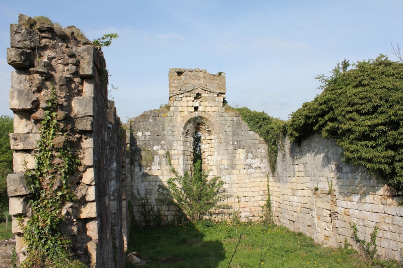
The monument includes the remains of a church and associated graveyard,
situated within the small settlement at Grindon.
The church at Grindon was originally built during the 12th century and
substantially rebuilt by Bishop Pudsey in 1190. It was dedicated to St Thomas
a Becket who was canonized in 1172. The visible remains include parts of the
nave, chancel and south chapel. The nave is rectangular and 15m east to west
by 6.5m north to south within walls of limestone blocks on average 1m thick.
The north and south walls stand to a maximum height of 5m and the west gable
stands to its full height of 7.2m. The main doorway into the church is visible
in the western end of the south wall of the nave. The doorway is a
particularly fine example, with a semi-circular arch supported on columns. A
second doorway of square-headed form in the north wall of the nave has been
blocked. There are two original lancet windows in the south wall and a single
lancet window in the north wall of the nave. There is a later window at the
eastern end of the south wall. A large window, the remains of which include
part of the sill and one jamb, are visible at the eastern end of the north
wall. There is a single lancet window, centrally placed in the western gable,
and the remains of a bellcote.
The remains of the chancel survive to the east end of the nave and are
considered to be slightly earlier in date. The chancel is visible as the lower
courses of walls of rubble masonry, except the north wall which stands to 2.2m
high and retains the sill of a window. The church was altered during the 14th
century when a chapel, known as the Fulthorpe porch, was added to the south
side of the chancel. The chapel, rectangular in shape, measures 5m by 3.4m
within walls which stand up to 2.2m high. It has the remains of windows in the
west and south walls, and parts of a piscina with a broken bowl lie adjacent
to the eastern side of the south window. During the late 18th century the
church was extensively repaired. At this time, the small porch around the
south doorway was constructed; this is visible as rubble walls standing to a
maximum height of 1.1m. The lead roof was replaced with slate, parts of the
chancel were refaced in brick and the interior of the nave was panelled with
wood; the holes facilitating the wooden panelling are clearly visible. In
addition to these alterations, a brick fireplace was inserted in the south
wall of the nave in order to heat the `Wynyard Pew'.
The church, which is Listed Grade I, remained in use until 1848 when it was
abandoned and superseded by the opening of the church of the Holy Trinity
at Thorpe Thewles. Surrounding the church on all sides there are the remains
of an associated graveyard 70m east to west by 55m north to south within a
broad bank up to 1.5m high and spread to 5m. The graveyard remained in use
until the church was abandoned. Vegetation cover has obscured the graves and
their headstones with the exception of a large slab immediately outside the
west end of the church. Until at least 1928 a stone coffin and a medieval
grave slab, the latter engraved with the name `Roger de Fulthorpe,' were
visible in the churchyard to the south east of the church. It is thought that
the latter had originally been placed in the `Fulthorpe Chapel'.
All fences which cross the monument and the wooden stile are excluded from the
scheduling, although the ground beneath these features is included.
MAP EXTRACT
The site of the monument is shown on the attached map extract.
It includes a 2 metre boundary around the archaeological features,
considered to be essential for the monument's support and preservation.
Source: Historic England
A parish church is a building, usually of roughly rectangular outline and
containing a range of furnishings and fittings appropriate to its use for
Christian worship by a secular community, whose members gather in it on
Sundays and on the occasion of religious festivals. Children are initiated
into the Christian religion at the church's font and the dead are buried in
its churchyard. Parish churches were designed for congregational worship and
are generally divided into two main parts: the nave, which provides
accommodation for the laity, and the chancel, which is the main domain of the
priest and contains the principal altar. Either or both parts are sometimes
provided with aisles, giving additional accommodation or spaces for additional
altars. Most parish churches also possess towers, generally at the west
end, but central towers at the crossing of nave and chancel are not uncommon
and some churches have a free-standing or irregularly sited tower. Many parish
churches also possess transepts at the crossing of chancel and nave, and south
or north porches are also common. The main periods of parish church foundation
were in the 10th to 11th and 19th centuries. Most medieval churches were
rebuilt and modified on a number of occasions and hence the visible fabric of
the church will be of several different dates, with in some cases little
fabric of the first church being still easily visible.
Parish churches are found throughout England. Their distribution reflects the
density of population at the time they were founded. In regions of dispersed
settlement parishes were often large and churches less numerous. The densest
clusters of parish churches were found in thriving medieval towns. A survey of
1625 reported the existence of nearly 9000 parish churches in England. New
churches built in the 18th, 19th and 20th centuries increased numbers to
around 18,000 of which 17,000 remain in ecclesiastical use. Parish churches
have always been major features of the landscape and a major focus of life for
their parishioners. They provide important insights into medieval and later
population levels or economic cycles, religious activity, artistic endeavour
and technical achievement. A significant number of surviving examples are
identified to be nationally important.
Despite some structural instability, St Thomas a Becket's Church survives
reasonably well. Important parts of the original medieval church remain intact
and it retains architectural features considered to be of high architectural
merit. Taken together with the remains of its graveyard, it will contribute to
our knowledge and understanding of medieval life and society.
Source: Historic England
Other
0652,
Source: Historic England
Other nearby scheduled monuments