Approximate Location Map
Large Map »
This site is entirely user-supported. See how you can help.
If Google Street View is available, the image is from the best available vantage point looking, if possible, towards the location of the monument. Where it is not available, the satellite view is shown instead.
Latitude: 50.7103 / 50°42'37"N
Longitude: -3.4579 / 3°27'28"W
OS Eastings: 297158.895738
OS Northings: 91091.03655
OS Grid: SX971910
Mapcode National: GBR P3.1TYV
Mapcode Global: FRA 37N6.DP3
Entry Name: Clyst St Mary Bridge and causeway
Scheduled Date: 30 October 1928
Last Amended: 6 July 2001
Source: Historic England
Source ID: 1020209
English Heritage Legacy ID: 33035
County: Devon
Civil Parish: Clyst St. Mary
Built-Up Area: Clyst St Mary
Traditional County: Devon
Lieutenancy Area (Ceremonial County): Devon
Church of England Parish: Sowton St Michael and All Angels
Church of England Diocese: Exeter
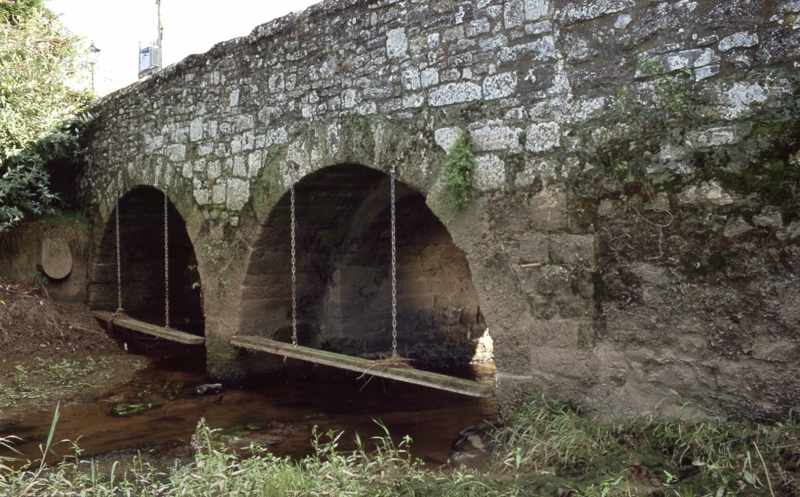
The monument includes Clyst St Mary Bridge and causeway. The bridge, which is
first recorded in the early decades of the 13th century, comprises several
arches linked by a walled causeway which once carried the road from Sidmouth
to Exeter across the River Clyst and its flood plain. The bridge stands just
to the west of the village of Clyst St Mary (formerly Bishop's Clyst) about
5km east of Exeter at a crossing point of the river which may have been in use
during the Roman period.
The stone-built bridge is considered to be the oldest surviving medieval
bridge in Devon outside the city of Exeter with an earliest documentary
reference of 1238 (as `pontem de Clist'). The bridge has been shown to display
at least four episodes of construction ranging from the medieval to the post-
medieval periods. Earlier commentators have suggested that the two low
segmental arches spanning the River Clyst itself at the western end of the
bridge represent the most ancient part of the structure, possibly that
referred to in 1238. These arches are 3.4m wide and they would have carried a
roadway 2.8m in width. Each vault is supported by four chamfered ribs
springing from a level 1.16m above a plinth.
Construction is of trap (a volcanic basalt) and sandstone ashlar; the ribs are
entirely of sandstone. Significantly, there is no Heavitree stone in their
construction. Major quarrying of the distinctive red breccia known as
Heavitree stone took place in nearby areas, including the parish of Heavitree
from whence the stone derived its name, from the mid-14th century onwards. Its
absence in the western bridge arches would support a suggested 13th-early 14th
century date for construction; quarries of volcanic trap lie at much greater
distance and Heavitree stone would almost certainly have been used had it been
available to the early bridge builders. The absence of Heavitree stone may
likewise be cited to suggest a similar early date for the single arch at the
centre of the causeway and the two arches at the eastern end of the bridge
which carry it across the mill leat. These three arches are sufficiently
similar in construction to suggest that they were built at the same time
although they are clearly of a different character to the western arches and
may be the product of a recorded substantial improvement to the bridge
which was made in 1310. These three spans at the centre and east of the bridge
have a chamfered plinth at the base and are wider than those at the west thus
allowing for an increased road width, 3.94m wide in the case of the central
arch, 3.35m wide over the two eastern arches which cross the mill leat. The
mill, which is known to have been in existence by 1374, lies 250m upstream of
the bridge.
The revetment walls and buttresses of the causeway appear to be substantially
of one build. In this case extensive use has been made of Heavitree stone
which suggests a mid-14th century or later date for their construction. An
order to undertake major repairs in 1603 is believed to relate to the causeway
rather than the arches.
All five medieval arches were however widened after the mid-19th century by
the addition of semi-circular arches of breccia on both the north and south
sides.
Clyst St Mary Bridge was reportedly the site of a minor battle of the Wars of
the Roses in 1455 but it also featured in the Western Prayer Book Rebellion of
1549 when it was barricaded against the King's forces led by Sir Peter Carew.
This followed an incident in which an elderly lady parishioner of the village
was upbraided by Sir Walter Raleigh (father of the famous explorer) for openly
displaying her Catholic rosary in contravention of the new liturgy. Further
acts of rebellion led to an army being dispatched from London and on Sunday
4th August 1549 the village was captured and burnt with the rebels falling
back onto the west bank of the River Clyst but continuing to defend the narrow
bridge. Unable to cross the bridge, royalist troops forded the river further
upstream and attacked the bridge rebels from behind. A battle ensued at Clyst
Heath which led to a victory for the King's army who then marched into Exeter
to find that all the surviving insurgents had dispersed.
Excluded from the scheduling are the posts across the eastern end of the
bridge carriageway which prevent vehicular access, and the modern surfacing of
the carriageway; the ground and bridge fabric beneath these features is,
however, included.
MAP EXTRACT
The site of the monument is shown on the attached map extract.
Source: Historic England
Multi span bridges are structures of two or more arches supported on piers.
They were constructed throughout the medieval period for the use of
pedestrians and packhorse or vehicular traffic, crossing rivers or streams,
often replacing or supplementing earlier fords. During the early medieval
period timber was used, but from the 12th century stone (and later brick)
bridges became more common, with the piers sometimes supported by a
timber raft. Most stone or brick bridges were constructed with pointed arches,
although semi-circular and segmental examples are also known. A common
medieval feature is the presence of stone ashlar ribs underneath the arch. The
bridge abutments and revetting of the river banks also form part of the
bridge. Where medieval bridges have been altered in later centuries, original
features are sometimes concealed behind later stonework, including remains of
earlier timber bridges. The roadway was often originally cobbled or gravelled.
The building and maintenance of bridges was frequently carried out by the
church and by guilds, although landowners were also required to maintain
bridges. From the mid-13th century the right to collect tolls, known as
pontage, was granted to many bridges, usually for repairs; for this purpose
many urban bridges had houses or chapels on them, and some were fortified with
a defensive gateway. Medieval multi span bridges must have been numerous
throughout England, but most have been rebuilt or replaced and less than 200
examples are now known to survive. As a rare monument type largely unaltered,
surviving examples and examples that retain significant medieval and post-
medieval fabric are considered to be of national importance.
Clyst St Mary Bridge survives particularly well without any major modern
refurbishment or strengthening. Its fabric preserves medieval masonry and
features in all of its five arches and its causeway wall provides a coherent
and ancient linkage between the separate arches as well as contributing to the
bridge's aesthetic qualities. The periods of construction of the bridge have
been studied in detail and published in county archaeological journals, while
the bridge is mentioned in several historical documents relating to the
Western Prayer Book Rebellion of 1549. The monument acts as a visible reminder
of significant events in local history as well as displaying clearly visible
and recorded features of 13th-14th century medieval bridge construction
techniques.
Source: Historic England
Books and journals
Axford, J, Clyst St Mary, (2000), 85-93
Gover, J E B et al, The Place Names of Devon, (1932), 586
Henderson, C, Jervoise, E , Old Devon Bridges, (1938), 68-69
Whitaker, R, Clyst St Mary, (1954)
Brown, S W, 'Proceedings of the Devon Archaeological Society' in The Medieval Bridge and St Gabriel's Chapel, Bishop's Clyst, , Vol. 40, (1982), 163-69
Source: Historic England
Other nearby scheduled monuments