Approximate Location Map
Large Map »
This site is entirely user-supported. See how you can help.
If Google Street View is available, the image is from the best available vantage point looking, if possible, towards the location of the monument. Where it is not available, the satellite view is shown instead.
Latitude: 50.957 / 50°57'25"N
Longitude: -4.1669 / 4°10'0"W
OS Eastings: 247907.634172
OS Northings: 119739.546964
OS Grid: SS479197
Mapcode National: GBR KL.N26N
Mapcode Global: FRA 265L.0GR
Entry Name: Rothern Bridge
Scheduled Date: 26 November 1928
Last Amended: 24 April 2002
Source: Historic England
Source ID: 1020702
English Heritage Legacy ID: 34444
County: Devon
Civil Parish: Great Torrington
Traditional County: Devon
Lieutenancy Area (Ceremonial County): Devon
Church of England Parish: Great Torrington St Michael
Church of England Diocese: Exeter
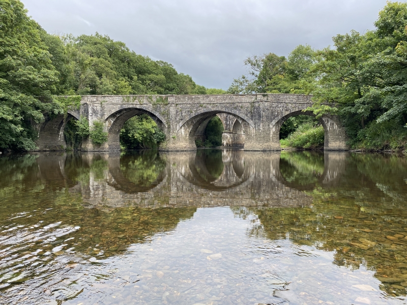
The monument includes a four arched stone road bridge spanning the River
Torridge near Torrington. The earliest surviving fabric of the bridge is
probably early 15th century. The original elements of the bridge comprise
narrow arches rising sharply from piers to a slight point. The road
carried on these arches would have been in the order of 2.75m to 3m wide.
The bridge was widened in the early part of the 19th century by adding new
arches springing from the cutwaters and this increased the road width to
4.7m. The parapet denoting the edge of the roadway measures 0.75m high by
0.4m wide and is of rubble construction with a dressed stone coping. The
bridge was rendered redundant in 1928 when the nearby Rolle Bridge was
constructed.
The bridge is Listed Grade II.
The modern road surface is excluded from the scheduling, although the
ground beneath it is included.
MAP EXTRACT
The site of the monument is shown on the attached map extract.
It includes a 2 metre boundary around the archaeological features,
considered to be essential for the monument's support and preservation.
Source: Historic England
Multi-span bridges are structures of two or more arches supported on
piers. They were constructed throughout the medieval period for the use
of pedestrians and packhorse or vehicular traffic, crossing rivers or
streams, often replacing or supplementing earlier fords. During the early
medieval period timber was used, but from the 12th century stone (and
later brick) bridges became more common, with the piers sometimes
supported by a timber raft. Most stone or brick bridges were constructed
with pointed arches, although semicircular and segmental examples are also
known. A common medieval feature is the presence of stone ashlar ribs
underneath the arch. The bridge abutments and revetting of the river banks
also form part of the bridge. Where medieval bridges have been altered in
later centuries, original features are sometimes concealed behind later
stonework, including remains of earlier timber bridges. The roadway was
often originally cobbled or gravelled. The building and maintenance of
bridges was frequently carried out by the church and by guilds, although
landowners were also required to maintain bridges. From the mid-13th
century the right to collect tolls, known as pontage, was granted to many
bridges, usually for repairs; for this purpose many urban bridges had
houses or chapels on them, and some were fortified with a defensive
gateway. Medieval multi-span bridges must have been numerous throughout
England, but most have been rebuilt or replaced and less than 200 examples
are now known to survive. As a rare monument type largely unaltered,
surviving examples and examples that retain significant medieval and post-
medieval fabric are considered to be of national importance.
Rothern Bridge survives very well and although still used very occasionally by
some vehicular traffic, it is now primarily a focus for visitors.
Architectural and archaeological information concerning the construction and
development of this bridge survives within its fabric.
Source: Historic England
Other
Devon County Sites and Monuments Register, SS41NE9, (1997)
Source: Historic England
Other nearby scheduled monuments