Approximate Location Map
Large Map »
This site is entirely user-supported. See how you can help.
If Google Street View is available, the image is from the best available vantage point looking, if possible, towards the location of the monument. Where it is not available, the satellite view is shown instead.
Latitude: 54.3692 / 54°22'9"N
Longitude: -0.5136 / 0°30'48"W
OS Eastings: 496664.47867
OS Northings: 498099.207178
OS Grid: SE966980
Mapcode National: GBR SKVX.LJ
Mapcode Global: WHGBL.2FPT
Entry Name: Round barrow known as one of the Three Howes, 780m WNW of Teydale Farm
Scheduled Date: 25 November 1969
Last Amended: 19 February 2001
Source: Historic England
Source ID: 1019764
English Heritage Legacy ID: 34572
County: North Yorkshire
Civil Parish: Stainton Dale
Traditional County: Yorkshire
Lieutenancy Area (Ceremonial County): North Yorkshire
Church of England Parish: Hackness with Harwood Dale
Church of England Diocese: York
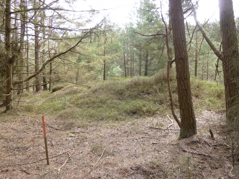
The monument includes a round barrow which occupies a prominent ridge top
position in Harwood Dale Forest. It is situated on Middle Jurassic sandstone
towards the eastern edge of the North York Moors.
The barrow has an earth and stone mound which stands up to 1.2m high and
measures 13m in diameter. The mound was originally surrounded by a kerb of
stones which supported it and defined the barrow. However, over the years
these have been taken away or become buried by soil slipping from the mound so
that now only one is visible on the northern perimeter of the mound. The
centre of the mound has been hollowed out by partial excavation in the past.
The barrow is one in a line of three and lies in an area where there are many
prehistoric monuments, including further barrows as well as field systems and
clearance cairns.
MAP EXTRACT
The site of the monument is shown on the attached map extract.
It includes a 2 metre boundary around the archaeological features,
considered to be essential for the monument's support and preservation.
Source: Historic England
Round barrows are funerary monuments dating from the Late Neolithic period to
the Late Bronze Age, with most examples belonging to the period 2400-1500 BC.
They were constructed as earthen mounds, sometimes ditched, which covered
single or multiple burials. They occur either in isolation or grouped as
cemeteries and often acted as a focus of burials in later periods. Often
superficially similar, although differing widely in size, they exhibit
regional variations in form and a diversity of burial practices. There are
over 10,000 surviving examples recorded nationally (many more have already
been destroyed), occurring across most of Britain, including the Wessex area
where it is often possible to classify them more closely, for example as bowl
or bell barrows. Often occupying prominent locations, they are a major
historic element in the modern landscape and their considerable variation in
form and longevity as a monument type provide important information on the
diversity of beliefs and social organisations amongst early prehistoric
communities. They are particularly representative of their period and a
substantial proportion of surviving examples are considered worthy of
protection.
Despite limited disturbance, the round barrow known as one of the Three Howes,
780m WNW of Teydale Farm has survived well. Significant information about the
original form of the barrow and the burials placed within it will be
preserved. Evidence for earlier land use and the contemporary environment will
also survive beneath the barrow mound. The barrow is one in a line of three.
Such clusters provide important insight into the development of ritual and
funerary practice during the Bronze Age. It is situated within an area which
also includes other groups of burial monuments as well as field systems and
clearance cairns. Associated groups of monuments such as these offer important
scope for the study of the distribution of prehistoric activity across the
landscape.
Source: Historic England
Other
Craster, OE, AM7, (1969)
Title: 2nd Edition 25" Ordnance Survey sheet 62/6
Source Date: 1928
Author:
Publisher:
Surveyor:
Title: Forestry Commission Areas North York Moors Archaeological Survey
Source Date: 1992
Author:
Publisher:
Surveyor:
Site 5.11
Source: Historic England
Other nearby scheduled monuments