Approximate Location Map
Large Map »
This site is entirely user-supported. See how you can help.
If Google Street View is available, the image is from the best available vantage point looking, if possible, towards the location of the monument. Where it is not available, the satellite view is shown instead.
Latitude: 55.1665 / 55°9'59"N
Longitude: -1.6871 / 1°41'13"W
OS Eastings: 420031.791659
OS Northings: 585847.191645
OS Grid: NZ200858
Mapcode National: GBR J8NP.KR
Mapcode Global: WHC2R.1DXL
Entry Name: Morpeth Old Bridge
Scheduled Date: 2 February 1961
Last Amended: 28 January 2003
Source: Historic England
Source ID: 1020744
English Heritage Legacy ID: 35421
County: Northumberland
Civil Parish: Morpeth
Built-Up Area: Morpeth
Traditional County: Northumberland
Lieutenancy Area (Ceremonial County): Northumberland
Church of England Parish: Morpeth
Church of England Diocese: Newcastle
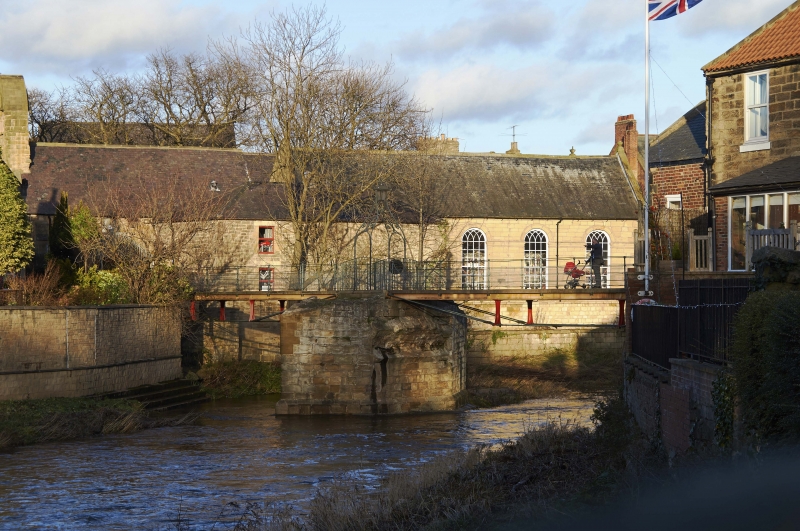
The monument includes the above and below ground remains of Morpeth Old
Bridge, a medieval multi-span bridge of 13th century date, which spanned
the River Wansbeck in Morpeth. The bridge was in use until 1835 when it
was partially demolished and replaced by a new bridge downstream. The
abutments and central pier remain standing to about 4m high and are
surmounted by a 19th century footbridge. The bridge is Listed Grade II.
The bridge, built of squared sandstone, had two segmental arches supported
on a central stone pier; the timber foundations of the latter were
revealed during low water levels in 1972. The northern arch had a span of
15.6m while the southern arch had a span of 17.4m. The north and south
abutments each retain the springing of an arch, and the central pier shows
the springing of the southern arch; on the north face the pier has been
cut back and partly reconstructed. To counteract the abrasive action
around the bridge foundations, the river bed beneath the northern arch is
paved with stone blocks which overlie a timber grid. Some of these timbers
were visible during a survey in 1993. The addition of upstream and
downstream cutwaters, or triangular projections, to the central pier aids
the flow of water and helps counteract the abrasive action of the river.
The cutwaters were carried up to parapet level and would have formed
niches into which pedestrians could retreat. The total length of the
bridge, inclusive of its abutments, is 38m and it was about 4m wide.
The bridge is first documented in the Chartulary of Newminster in the 13th
century, and the bridge and its chapel are recorded in 1294. The bridge
was managed by a chaplain who was also called the keeper.
A number of features are excluded from the scheduling. These are: the
stone steps, modern wall, concrete paving, drain cover, modern stone
structure, and pieces of sculpted stone beneath the north end of the
bridge, the concrete steps along the west side of the riverbank, a brick
outhouse, brick walls and stone capstones at the southern abutment, all
walls above pavement level, and the 19th century pedestrian footbridge,
although the ground beneath all these features is included.
MAP EXTRACT
The site of the monument is shown on the attached map extract.
Source: Historic England
Multi-span bridges are structures of two or more arches supported on
piers. They were constructed throughout the medieval period for the use
of pedestrians and packhorse or vehicular traffic, crossing rivers or
streams, often replacing or supplementing earlier fords. During the early
medieval period timber was used, but from the 12th century stone (and
later brick) bridges became more common, with the piers sometimes
supported by a timber raft. Most stone or brick bridges were constructed
with pointed arches, although semicircular and segmental examples are also
known. A common medieval feature is the presence of stone ashlar ribs
underneath the arch. The bridge abutments and revetting of the river banks
also form part of the bridge. Where medieval bridges have been altered in
later centuries, original features are sometimes concealed behind later
stonework, including remains of earlier timber bridges. The roadway was
often originally cobbled or gravelled. The building and maintenance of
bridges was frequently carried out by the church and by guilds, although
landowners were also required to maintain bridges. From the mid-13th
century the right to collect tolls, known as pontage, was granted to many
bridges, usually for repairs; for this purpose many urban bridges had
houses or chapels on them, and some were fortified with a defensive
gateway. Medieval multi-span bridges must have been numerous throughout
England, but most have been rebuilt or replaced and less than 200 examples
are now known to survive. As a rare monument type largely unaltered,
surviving examples and examples that retain significant medieval and post-
medieval fabric are considered to be of national importance.
Although the two segmental arches were removed in 1835, the central pier
and the two abutments of the 13th century Morpeth Old Bridge remain in
situ. The surviving remains will provide evidence of bridge construction
and the way in which rivers were crossed in the medieval period. The
crossing of the River Wansbeck was of great strategic importance and was
defended by Morpeth Castle to the south. The Morpeth Old Bridge's
importance is enhanced by its association with a chantry chapel at the
north end of the bridge, and in particular by the survival of a timber
substructure revealed during a survey in 1972.
Source: Historic England
Books and journals
Ryder, P, Sermon, R, Historic Bridges in Northumberland, (1993)
Other
11535,
Source: Historic England
Other nearby scheduled monuments