Approximate Location Map
Large Map »
This site is entirely user-supported. See how you can help.
If Google Street View is available, the image is from the best available vantage point looking, if possible, towards the location of the monument. Where it is not available, the satellite view is shown instead.
Latitude: 54.4148 / 54°24'53"N
Longitude: -0.7238 / 0°43'25"W
OS Eastings: 482918.528891
OS Northings: 502900.683969
OS Grid: NZ829029
Mapcode National: GBR RKDD.35
Mapcode Global: WHF94.V9JC
Entry Name: Allan Tofts cairnfield, field system, burial cairns and prehistoric rock art, immediately south of Morton Close
Scheduled Date: 15 April 2004
Source: Historic England
Source ID: 1021301
English Heritage Legacy ID: 35915
County: North Yorkshire
Civil Parish: Goathland
Traditional County: Yorkshire
Lieutenancy Area (Ceremonial County): North Yorkshire
Church of England Parish: Goathland St Mary
Church of England Diocese: York
The monument includes the earthwork and buried remains of a cairnfield
which is situated on Middle Jurassic sandstone on the North York Moors. It
lies at the north western edge of Goathland Moor, in the angle between the
steep slopes of Allan Bank and Water Ark Scar and overlooking the valleys
of the Murk Esk and Eller Beck.
Within the cairnfield and associated with it are an irregular aggregate
field system, four round burial cairns and four cup or cup and ring marked
stones. Also included are a linear boundary, thought to be of medieval
date, and numerous tracks and hollow ways dating to the medieval and
post-medieval periods. All these additional archaeological features are
included in the scheduling.
The cairnfield includes a large number of cairns which are scattered over
a wide area from the 150m contour to above the 200m contour. The cairns
are distributed in several concentrations on a series of terraces which
are either level or slope gently in a westerly or southerly direction.
About 150 cairns have been mapped and appear on the early editions of the
Ordnance Survey maps, but more recent fieldwork has shown that there were
at least 220 cairns originally, most of which survive as earthworks. These
are visible as well-defined sub-circular mounds constructed from small and
medium sized stones, which stand up to 0.6m high. Some are built around
large erratic boulders. In the northern and eastern parts of the
cairnfield, the cairns range from 1.5m to 5m in diameter, but in the
central and western parts, they are generally larger and measure 3m to 6m
in diameter, with a few up to 8m in diameter. The majority are field
clearance cairns which are the result of clearing the ground to prepare
for agriculture, but some of the larger cairns, particularly at the
western edge of the cairnfield, are thought to have been used as burial
mounds. These latter cairns often have a hollow in the centre which has
been produced by previous investigation. There are, in addition, four
round funerary cairns which are larger and situated in more prominent
positions than others within the cairnfield. These have well-defined stony
mounds which measure 8m-12m in diameter and stand 0.5m-0.9m high. Partial
excavation in the past has also left a central depression on top of each
mound. One cairn, at NGR NZ82660271, is disguised by a post-medieval sheep
bield, known as Redmond's Bield, which has been constructed over the top
of the mound on its north eastern and north western edges. Two cairns, at
NGRs NZ83080296 and NZ83120306, have uneven surfaces with boulders
exposed within the matrix of the mound. The fourth cairn lies at NGR
NZ82960272.
Superimposed upon the cairnfield and curving around the south western and
southern slopes of the monument, largely between the 170m and 190m
contours, are the remains of a prehistoric field system. This survives as
fragmentary boundaries around a number of irregularly shaped, contiguous
enclosures or cultivation plots which measure approximately 30m to 60m
across. The boundaries are visible as banks of earth and stone, 2m-3m wide
and 0.4m-0.7m high, which occasionally incorporate cairns, boulders and
orthostats, or earthfast stones. Five such orthostats were marked on the
1913 edition of the Ordnance Survey map, but only one of these is still
visible, although there are at least another four isolated orthostats
within the cairnfield.
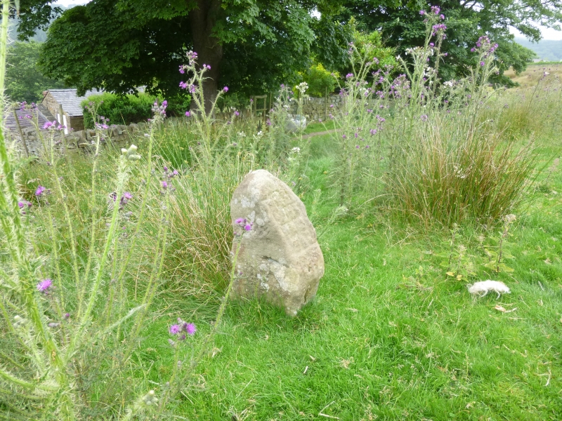
Four examples of prehistoric rock art lie within the cairnfield, located
on small boulders which are natural outcrops. The first site is at NGR
NZ82950274, which lies about 17m to the north of one of the funerary
cairns. The boulder measures approximately 1m across and its surface,
which is almost level with the ground surface, is decorated with three
large cup marks, each of which is surrounded by a ring. There are also
several shallow grooves connecting the rings and two smaller cup marks.
The second site is at NGR NZ83170283. The boulder measures approximately
0.7m by 0.6m and is decorated with three cup marks, each surrounded by a
ring, with two of the rings adjoining. The third site is the smallest of
the four and is at NGR NZ82930301. The boulder measures approximately 0.8m
by 0.6m and has four small cup marks, arranged in a Y-shaped pattern. The
fourth site is the largest and has the most complex area of decoration. It
lies at NGR NZ82650281, about 80m north of one of the funerary cairns. The
boulder is approximately triangular in plan, with sides of 0.8m-1m, and
stands up to 0.3m high. There are two decorated faces. On the north east
face, and extending onto the upper surface there are at least 14 cup
marks, arranged in lines, which are crossed and linked by a number of
shallow grooves, including one which forms a curve. Below the cup marks
there is a pattern of shallow grooves which cross each other. On the
western face there is a shallow groove running approximately horizontally,
with five further grooves crossing it and at least two cup marks. Some of
the decoration is partly obscured by peat and vegetation at the edges of
the boulder.
The prehistoric features within the cairnfield and field system continued
to have an impact on the use of the landscape into the medieval and
post-medieval periods. Running through the cairnfield in a north to south
direction there is a linear boundary which is different in character from
the prehistoric field boundaries. This boundary is about 440m long and
survives as an irregular bank of cleared stone and boulders which is 3m
wide and 0.4m-0.6m high. The bank incorporates some of the prehistoric
clearance cairns and occasionally orthostats, or earthfast stones. In
places it splits into two, or has fragments of parallel banks 10m-20m away
which form narrow irregular enclosures. There are also traces of banks on
either side running approximately perpendicular to it. These adjoining and
parallel banks are considered to be components of the earlier, prehistoric
field system, which have been included within a later boundary. It is
known that the modern pattern of fields in the area around the monument
originated with enclosures dating from the 13th century, including those
to the immediate east of the monument, and this boundary is considered
also to belong to the medieval period, although it incorporates elements
of the prehistoric field system. Since at least the post-medieval period
the area has been used for grazing sheep and there are several sheep
bields which have been constructed within the monument; some of these are
also likely to have incorporated fragments of the prehistoric field
system.
Throughout the monument there are numerous paths, tracks and hollow ways
which are evidence for the continued use of this area for grazing during
the medieval and post-medieval periods. The most substantial of these are
hollow ways which run down the steeper slopes at the edges of the
monument, towards farmsteads to the north, west, south west and south
east; they are considered to be medieval and contemporary with the
earliest farmsteads, but some may have had a prehistoric origin. On the
northern fringes of the monument, the hollow ways run approximately east
to west before turning to the north west to run down the steeper slope,
and here there are up to eight different parallel routes which are up to
2m deep. These are thought originally to have been part of a route between
a former medieval grange of Malton Priory, on the site of the modern
farmstead of Morton Close, and the Whitby to Pickering road. The monument
is surrounded by many more remains from the prehistoric period, which
include further cairnfields as well as ritual and funerary monuments.
A number of features are excluded from the scheduling. These are: the
surfaces of the modern access tracks at the eastern side of the monument,
the walls of the sheep bields at NGRs NZ82970303, NZ83000291 (Boggle
Bield) and NZ82850277, the corrugated iron shed at NGR NZ83000330 and the
walls of the ruined sheep fold at NGR NZ83230270; however, the ground
beneath all these features is included in the scheduling.
MAP EXTRACT
The site of the monument is shown on the attached map extract.
Source: Historic England
Cairnfields are concentrations of cairns sited in close proximity to one
another. They often consist largely of clearance cairns, built with stone
cleared from the surrounding landsurface to improve its use for agriculture,
and on occasion their distribution pattern can be seen to define field plots.
However, funerary cairns are also frequently incorporated, although without
excavation it may be impossible to determine which cairns contain burials.
Clearance cairns were constructed from the Neolithic period (from c.3400 BC),
although the majority of examples appear to be the result of field clearance
which began during the earlier Bronze Age and continued into the later Bronze
Age (2000-700 BC). The considerable longevity and variation in the size,
content and associations of cairnfields provide important information on the
development of land use and agricultural practices. Cairnfields also retain
information on the diversity of beliefs and social organisation during the
prehistoric period.
Round cairns are prehistoric funerary monuments dating to the Bronze Age
(c.2000-700 BC). They were constructed as stone mounds covering single or
multiple burials. These burials may be placed within the mound in
stone-lined compartments called cists. In some cases the cairn was
surrounded by a ditch. Often occupying prominent locations, cairns are a
major visual element in the modern landscape. They are a relatively common
feature of the uplands and are the stone equivalent of the earthen round
barrows of the lowlands. Their considerable variation in form and
longevity as a monument type provide important information on the
diversity of beliefs and social organisation amongst early prehistoric
communities. They are particularly representative of their period and a
substantial proportion of surviving examples are considered worthy of
protection.
Regular aggregate field systems date from the Bronze Age (2000-700 BC) to
the end of the fifth century AD. They usually cover areas of up to 100ha
and comprise a discrete block of fields orientated in roughly the same
direction, with the field boundaries laid out along two axes set at right
angles to one another. Individual fields generally fall within the
0.1ha-3.2ha range and can be square, rectangular, long and narrow,
triangular or polygonal in shape. The field boundaries can take various
forms (including drystone walls or reaves, orthostats, earth and rubble
banks, pit alignments, ditches, fences and lynchets) and follow straight
or sinuous courses. Component features common to most systems include
entrances and trackways, and the settlements or farmsteads from which
people utilised the fields over the years have been identified in some
cases. These are usually situated close to or within the field system.
The development of field systems is seen as a response to the competition
for land which began during the later prehistoric period. The majority are
thought to have been used mainly for crop production, evidenced by the
common occurrence of lynchets resulting from frequent ploughing, although
rotation may also have been practised in a mixed farming economy. Regular
aggregate field systems occur widely and have been recorded in south
western and south eastern England, East Anglia, Cheshire, Cumbria,
Nottinghamshire, North and South Yorkshire and Durham. They represent a
coherent economic unit often utilised for long periods of time and can
thus provide important information about developments in agricultural
practices in a particular location and broader patterns of social,
cultural and environmental change over several centuries. Those which
survive well and/or which can be positively linked to associated
settlements are considered to merit protection.
Prehistoric rock art is found on natural rock outcrops in many areas of
upland Britain. It is especially common in the north of England in
Northumberland, Durham and North and West Yorkshire. The most common form
of decoration is the `cup and ring' marking, where expanses of small
cup-like hollows are pecked into the surface of the rock. These cups may
be surrounded by one or more `rings'. Single pecked lines extending from
the cup through the rings may also exist, providing the design with a
`tail'. Pecked lines or grooves can also exist in isolation from cup and
ring decoration. Other shapes and patterns also occur, but are less
frequent. Carvings may occur singly, in small groups, or may cover
extensive areas of rock surface. They date to the Late Neolithic and
Bronze Age periods (2800-c.500 BC) and provide one of our most important
insights into prehistoric `art'. The exact meaning of the designs remains
unknown, but they may be interpreted as sacred or religious symbols.
Frequently they are found close to contemporary burial monuments and the
symbols are also found on portable stones placed directly next to burials
or incorporated into burial mounds. Around 800 examples of prehistoric
rock art have been recorded in England. This is unlikely to be a realistic
reflection of the number carved in prehistory. Many will have been
overgrown or destroyed in activities such as quarrying. All positively
identified prehistoric rock art sites exhibiting a significant group of
designs normally will be identified as nationally important.
Allan Tofts cairnfield, field system, burial cairns and prehistoric rock
art survive in an excellent state of preservation. Valuable evidence for
the nature of Bronze and Iron Age agriculture, the contemporary
environment and earlier land use will be preserved between and beneath the
cairns and field banks. Despite a little weathering of some of the
designs, the prehistoric rock art has survived very well and has not been
disturbed. On the North York Moors cup and cup and ring marked stones are
found largely within round barrows. These cup marked rocks lie in one of
only a few open moorland situations to have decorated in situ boulders.
The diversity and complexity of their designs is only matched on the North
York Moors by the concentration of decorated rocks on Fylingdales Moor to
the east. The relationships between features of different date will add
greatly to our understanding of the sequence of development and change,
and continuity of land use during the prehistoric period. The associations
between the cairnfield, field system, burial cairns and rock art will
provide evidence for the relationships between agricultural, social and
ritual practice. The monument is situated within a landscape where there
are many other prehistoric monuments. Associations such as this contribute
to our understanding of the distribution of prehistoric activity across
the landscape.
Source: Historic England
Books and journals
Beckensall, S, British Prehistoric Rock Art, (1999), 64-68
Hollings, A, A History of Goathland, (1971), 23-29
Other
12230,
7721,
Title: 1st Edition Ordnance Survey 6" sheet 45
Source Date: 1853
Author:
Publisher:
Surveyor:
Title: 2nd Edition Ordnance Survey 25" sheet 45/12
Source Date: 1913
Author:
Publisher:
Surveyor:
Source: Historic England
Other nearby scheduled monuments