Approximate Location Map
Large Map »
This site is entirely user-supported. See how you can help.
If Google Street View is available, the image is from the best available vantage point looking, if possible, towards the location of the monument. Where it is not available, the satellite view is shown instead.
Latitude: 50.1336 / 50°8'0"N
Longitude: -5.2304 / 5°13'49"W
OS Eastings: 169238.155515
OS Northings: 30942.425356
OS Grid: SW692309
Mapcode National: GBR Z3.LP52
Mapcode Global: VH12Y.9W7Z
Entry Name: Round cairn with later shelter and beacon known as Beacon Hut, 430m NNW of Wheal Lovell Farm
Scheduled Date: 22 March 1932
Source: Historic England
Source ID: 1006658
English Heritage Legacy ID: CO 182
County: Cornwall
Civil Parish: Wendron
Traditional County: Cornwall
Lieutenancy Area (Ceremonial County): Cornwall
Church of England Parish: Wendron
Church of England Diocese: Truro
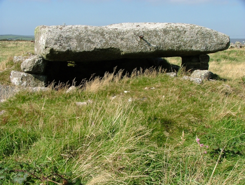
The monument includes a round cairn with a later shelter and beacon, situated close to the summit of a prominent ridge forming the watershed between the Helford and Cobe Rivers. The round cairn survives as a circular stony mound measuring up to 12.8m in diameter and 2.7m high. On the southern side of the cairn is a square chamber measuring approximately 2m wide and 1.9m high, defined by granite slabs and coursed walling and roofed with a massive capstone. This has three iron bars on top and holes which are the result of late 17th or early 18th century stone splitting techniques. On the north east side of the chamber is a recess measuring approximately 0.5m square, interpreted as a possible hearth.
First recorded on the Ordnance Survey map of 1907 as a 'cromlech', this monument has been variously described as an Iron Age dwelling and a megalithic tomb, but the use of coursed walling would be unusual in a megalithic structure. Daniel believes it had prehistoric origins but has been modified with a shelter for a beacon used during the Spanish Armada, the beacon itself being raised on the iron supports on top of the capstone.
Sources: HER:-
PastScape Monument No:-425935
Source: Historic England
Round cairns are prehistoric funerary monuments dating to the Bronze Age (c.2000-700 BC). They were constructed as earthen or rubble mounds, the latter predominating in areas of upland Britain where such raw materials were locally available in abundance. Round cairns may cover single or multiple burials and are sometimes surrounded by an outer ditch. Often occupying prominent locations, they are a major visual element in the modern landscape. Their considerable variation in form and longevity as a monument type provide important information on the diversity of beliefs and social organisation amongst early prehistoric communities. They are particularly representative of their period.
Shelters are small buildings which provided temporary accommodation for a variety of workers. Some were occupied seasonally and formed habitation for months at a time, whilst others were only used during work hours as shelters from inclement weather. Some probably had more than a single function, with parts of the structure being utilised for storage. Most were built of drystone walling and had a visible doorway, whilst some have fireplaces, cupboards and benches. Many shelters were constructed on virgin sites, but a significant number were built within earlier ruined structures such as prehistoric stone hut circles and medieval long houses. The function of each shelter can generally be ascertained by its proximity to other archaeological features. Shelters found within or close to mines or quarries are generally considered to have been built and occupied by those workers. In some circumstances a single building may have been used at different times by more than one group of workers including herdsmen.
Beacons were extensively used during the medieval period. Their use was formalised by 1325 and although some were used later, for example at the time of Monmouth's Rebellion in 1685 or during the Napoleonic wars, the system was in decay by the mid-17th century. Beacons were initially bonfires of wood or furze, but later barrels of pitch or iron fire baskets mounted on poles were used. The poles were occasionally set on earthen mounds. Access to the fire basket was by way of rungs set in the pole, or by a stone ladder set against the beacon. The round cairn with later shelter and beacon known as Beacon Hut, 430m NNW of Wheal Lovell Farm is an unusual combination of features which seem to indicate its adaptive re-use over a prolonged period. It will contain archaeological and environmental evidence relating to its construction, function, funerary practices, territorial significance, agricultural practices, social and political importance, economic importance and overall landscape context.
Source: Historic England
Other nearby scheduled monuments