Approximate Location Map
Large Map »
This site is entirely user-supported. See how you can help.
If Google Street View is available, the image is from the best available vantage point looking, if possible, towards the location of the monument. Where it is not available, the satellite view is shown instead.
Latitude: 51.368 / 51°22'4"N
Longitude: 0.2109 / 0°12'39"E
OS Eastings: 554001.836638
OS Northings: 165534.612804
OS Grid: TQ540655
Mapcode National: GBR TT.PVD
Mapcode Global: VHHP6.LWW5
Entry Name: Eynsford Bridge
Scheduled Date: 30 April 1935
Source: Historic England
Source ID: 1005170
English Heritage Legacy ID: KE 52
County: Kent
Civil Parish: Eynsford
Built-Up Area: Eynsford
Traditional County: Kent
Lieutenancy Area (Ceremonial County): Kent
Church of England Parish: Eynsford St Martin
Church of England Diocese: Rochester
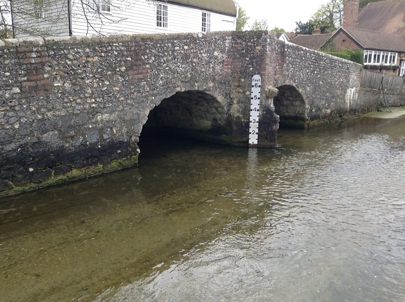
Eynsford Bridge, 83m north-west of the Church of St Martin.
Source: Historic England
This record was the subject of a minor enhancement on 18 December 2014. The record has been generated from an "old county number" (OCN) scheduling record. These are monuments that were not reviewed under the Monuments Protection Programme and are some of our oldest designation records.
The monument includes a multi-span stone bridge, dating from at least the 17th century, spanning the River Darent at Eynsford. It carries the road known as Riverside over the Darent.
The bridge includes two round-headed arches built of Kentish ragstone. Between the arches is a pointed cutwater on the upstream (southern) side and a rectangular recess, forming a pedestrian refuge, on the downstream (northern) side. The parapet is a later alteration and is built of flint and red brick. On the southern side of the bridge is a weathered medieval figure, probably an angel, with hands upraised.
Eynsford Bridge is Grade II listed.
Source: Historic England
Multi-span bridges are structures of two or more arches supported on piers. They were constructed throughout the medieval and post-medieval periods for the use of pedestrians and packhorse or vehicular traffic, crossing rivers or streams, often replacing or supplementing earlier fords. During the early medieval period timber was used, but from the 12th century stone (and later brick) bridges became more common, with the piers sometimes supported by a timber raft. Most stone or brick bridges were constructed with pointed arches, although semicircular and segmental examples are also known. A common feature is the presence of stone ashlar ribs underneath the arch. The bridge abutments and revetting of the river banks also form part of the bridge. Where bridges have been altered in later centuries, original features are sometimes concealed behind later stonework, including remains of earlier timber bridges.
Despite some later alterations, Eynsford Bridge is a well preserved example of a multi-span bridge dating from at least the 17th century. Deposits buried underneath the bridge will preserve valuable artefactual, ecofactual and environmental evidence, providing information about the human and natural history of the site prior to the construction of the bridge.
Source: Historic England
Other
Kent HER TQ56NW82. NMR TQ56NW82. PastScape 410204. LBS 414329.
Source: Historic England
Other nearby scheduled monuments