Approximate Location Map
Large Map »
This site is entirely user-supported. See how you can help.
If Google Street View is available, the image is from the best available vantage point looking, if possible, towards the location of the monument. Where it is not available, the satellite view is shown instead.
Latitude: 52.4295 / 52°25'46"N
Longitude: -2.8317 / 2°49'54"W
OS Eastings: 343544.982986
OS Northings: 281607.540579
OS Grid: SO435816
Mapcode National: GBR BF.N1JQ
Mapcode Global: VH76D.V6VC
Entry Name: Stokesay Castle
Scheduled Date: 18 November 1960
Last Amended: 2 September 2014
Source: Historic England
Source ID: 1003011
English Heritage Legacy ID: SA 8
County: Shropshire
Civil Parish: Craven Arms
Traditional County: Shropshire
Lieutenancy Area (Ceremonial County): Shropshire
Church of England Parish: Stokesay
Church of England Diocese: Hereford
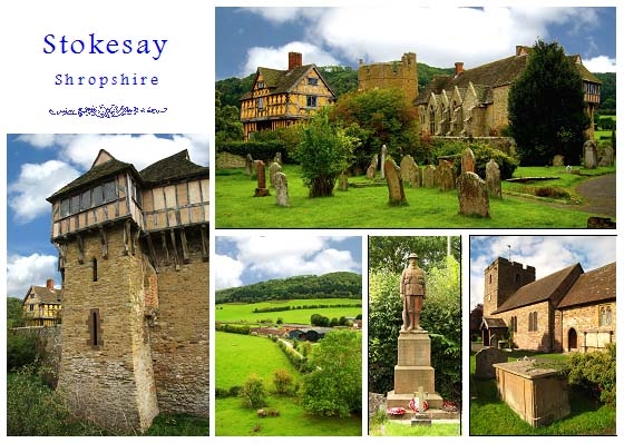
The monument includes a C13 fortified manor house with C17 gatehouse within a moated site, and associated gardens and water management system.
Source: Historic England
PRINCIPAL ELEMENTS
The monument includes a C13 fortified manor house with C17 gatehouse within a moated site, and associated gardens and water management system.
DESCRIPTION
The monument, which falls into two separate areas of protection, includes the fortified manor house, earthwork and buried remains of Stokesay Castle and part of its associated gardens. It is situated in the Welsh Marches, the England-Wales borderlands, in a valley bottom, to the west of the River Onny as it passes through Wenlock Edge. A roughly oval-shaped moat (now dry), with the remains of a perimeter wall which originally rose up to 10m above the bottom of the moat, encloses an area measuring approximately 50m NNE to SSW and 40m WNW to ESE, covering an area of approximately 0.17 hectares. The moat is circa 8m wide and up to 2m deep.
The moated island is raised above the surrounding ground level. At its NE corner stands a C17 timber-framed and elaborately decorated gatehouse. The original gatehouse was probably of stone; however, the current mid-C17 building is timber-framed with elaborately carved brackets and lozenge patterns, typical of houses in Ludlow of this period. At ground level the building has upright timbers infilled with plaster, and the upper floors are jettied out with square panels containing lozenges. There is a gable above the gate-passage which has a central window with a row of five stars beneath it, and a pattern of quarter circles above. Tree-ring analysis of the Gatehouse timbers date the construction to 1639-41.
At its western side stands an older range of buildings dating to the C13, built of sandstone rubble and timber-frame, with a stone tile roof. It includes a four-bay, open-hearthed great hall with an extraordinary roof which is a hybrid mixture of raised crucks, aisled end trusses and an unusual example of collar-purlins without crown posts. At its north end is a late-C13 timber stair which gives access to the upper floors of the north tower, with a jettied timber first floor of the C17. At the south end of the hall range is a cross wing housing the solar block, with the first-floor solar reached by an external stair; both ground and first floors have C17 interiors. To the south stands a stone tower, polygonal in plan, of three storeys, with crenellations. The kitchen, service range and other ancillary buildings would have filled the courtyard; these survive as buried features. The remains of a designed landscape and garden features include an artificial lake to the SW.
A complex system of ponds, dams, sluices and culverts is associated with the Castle. A leat takes water from the River Onny above the weir at Stokesay Bridge to a mill SE of the Castle. Earthworks between the Castle and the mill may represent a second mill-pond, fed from an independent source. A causeway S of the castle held back a pond, fed by a stream from the NW, which almost certainly supplied the castle moat, and which may also have served as a fishpond. Culverts under the causeway were controlled by sluices. Some of the works must be medieval in origin; the system is unlikely to be later than the first half of the C17.
EXCLUSIONS
All modern tracks, modern buildings and fence posts are excluded from the scheduling, but the ground beneath these is included.
Source: Historic England
The moated site, designed landscape and associated water features at Stokesay Castle, and the standing buildings within the moated site, together with the buried archaeological remains of those demolished parts of the complex, are scheduled for the following principal reasons:
* Survival: a well-preserved group of buildings and archaeological remains which represent the growth and development of this site from a moated medieval manor house to a fashionable C17 residence with ornamental gardens; as such they exhibit considerable longevity as monument types;
* Potential: buried archaeological evidence for the layout and types of structures that formerly occupied the rest of the courtyard will survive beneath the ground surface, whilst the moat ditches and the ponds will retain artefactual and environmental information relating to the occupation of the site; and the remains of the wider water management system will retain valuable evidence of its construction and the way in which it functioned;
* Historic interest: the post-medieval creation of an ornamental garden reflects the status and wealth of the Craven family and will provide a valuable insight into garden design at that time.
Source: Historic England
Books and journals
Pevsner N, , Newman, J, The Buildings of England: Shropshire, (2006), 609-14
Summerson, H, Stokesay Castle - English Heritage Guidebook, (2009)
Other
English Heritage: NMR Complete Monument Report 109049: Stokesay Castle ,
English Heritage: NMR Complete Monument Report 1521844: Stokesay Castle Gatehouse ,
Shropshire Historic Environment Record 00159: Stokesay Castle,
Shropshire Historic Environment Record 08250: Water management features at Stokesay Castle,
Shropshire Historic Environment Record 14855: Gatehouse at Stokesay Castle,
Source: Historic England
Other nearby scheduled monuments