Approximate Location Map
Large Map »
This site is entirely user-supported. See how you can help.
If Google Street View is available, the image is from the best available vantage point looking, if possible, towards the location of the monument. Where it is not available, the satellite view is shown instead.
Latitude: 54.8354 / 54°50'7"N
Longitude: -5.11 / 5°6'35"W
OS Eastings: 200371
OS Northings: 553384
OS Grid: NX003533
Mapcode National: GBR FHRX.XT2
Mapcode Global: WH1RF.GQXH
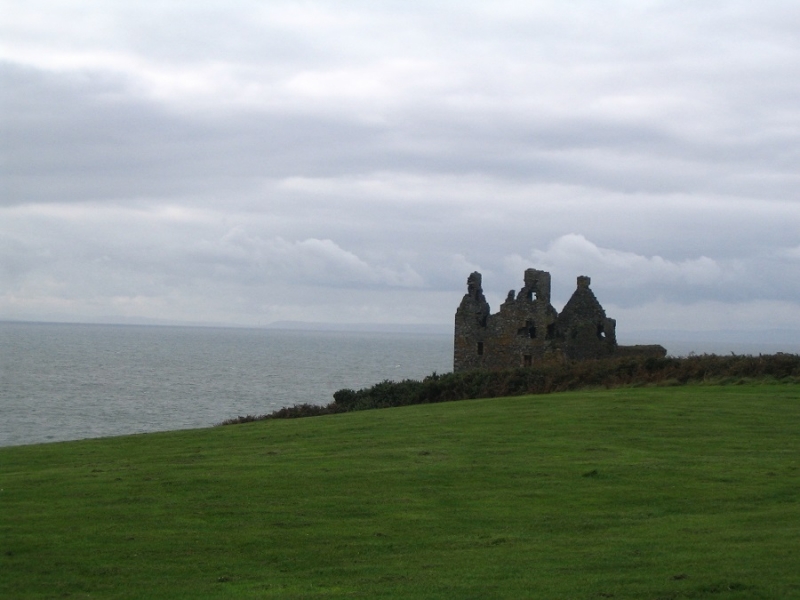
Entry Name: Dunskey Castle
Scheduled Date: 9 November 1938
Source: Historic Environment Scotland
Source ID: SM2017
Schedule Class: Cultural
Category: Secular: castle
Location: Portpatrick
County: Dumfries and Galloway
Electoral Ward: Stranraer and the Rhins
Traditional County: Wigtownshire
Halliman Skerries Beacon was built in 1844-1845 by the Northern Lighthouse Board to plans by the board's engineer, Alan Stevenson. This unlit beacon marks Halliman Skerries, a partially submerged group of rocky outcrops located around 1km north from the coast at Covesea, on the Moray Firth.
Halliman Skerries Beacon stands on bedrock and is an iron structure 14m in height, constructed of six columns of cast iron with horizontal bracing. The columns are surmounted by a cylindrical open iron cage with a cross on top. This served as a place of refuge for shipwrecked mariners. An iron platform and ladder within the columned structure provided access from ground level to the cage.
Historical development
The New Statistical Account (Drainie, County of Elgin, NSA, Vol.xiii, 1845) describes the threat posed by Halliman Skerries to shipping: 'on this fatal reef, more than forty vessels are known to have been wrecked within these fifty years past, and many no doubt have shared the same disastrous fate, that never have been known or heard of'.
The loss of 16 vessels in a storm in the Moray Firth in November 1826 led to representations to the Northern Lighthouse Board for establishment of lighthouses at nearby Covesea Skerries and Tarbat Ness (on the Black Isle) to mark the wide entrance to the Firth (Paxton and Shipway 2007a, 137-8). Robert Stevenson's lighthouse at Tarbat Ness became operational in 1830. The coast between Inverness to Kinnaird's Head remained without a light. Meanwhile, calls for a light at Covesea continued, including a request by the Magistrates and Town Council of Inverness in 1834 (Caledonian Mercury 2 August 1834).
In response to a petition from the Provost, Magistrates and Council of Wick, the Northern Lighthouse Board announced its intention to construct a lighthouse at Covesea and a beacon on the skerries in January 1842 (Scotsman 19 January 1842). The iron for the beacon was manufactured by the foundry of the Shotts Iron Company, Leith and landed at Stotfield Harbour, Lossiemouth before being transported out to the skerries in boats (Scotsman 28 August 1844).
The completion of the beacon and lighthouse were announced by Northern Lighthouse Board in a Notice To Mariners (Lloyds List 14 April 1846).
Source: Historic Environment Scotland
Bibliography
No Bibliography entries for this designation
Source: Historic Environment Scotland
Other nearby scheduled monuments