Approximate Location Map
Large Map »
This site is entirely user-supported. See how you can help.
If Google Street View is available, the image is from the best available vantage point looking, if possible, towards the location of the monument. Where it is not available, the satellite view is shown instead.
Latitude: 56.2263 / 56°13'34"N
Longitude: -4.0347 / 4°2'5"W
OS Eastings: 273944
OS Northings: 705616
OS Grid: NN739056
Mapcode National: GBR 17.CRK3
Mapcode Global: WH4NK.ZRVP
Entry Name: The Judge's Cairn, cairn 550m NW of Dalbrack
Scheduled Date: 2 March 1998
Source: Historic Environment Scotland
Source ID: SM6988
Schedule Class: Cultural
Category: Prehistoric ritual and funerary: cairn (type uncertain)
Location: Dunblane and Lecropt
County: Stirling
Electoral Ward: Trossachs and Teith
Traditional County: Perthshire
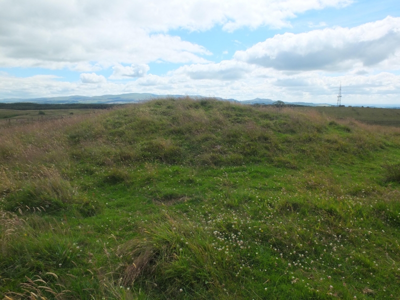
The monument comprises the remains of a burial cairn of prehistoric date, surviving as a turf-covered stony mound.
The monument lies on the crest of a ridge overlooking the valley of the Ardoch Burn, from which it appears as a prominent landscape feature, at around 190m OD.
It comprises the remains of an oval cairn some 22m N-S by about 18m transversely, rising to a height of about 1.8m. Robbing has removed some of the stone on the S and may partially account for its apparent oval shape. Burials and related ritual deposits may be expected to survive within, under and around the cairn.
The area to be scheduled encompasses the visible remains and an area around them in which traces of associated activity may be expected to survive. It is circular with a diameter of 50m as marked in red on the accompanying map.
Source: Historic Environment Scotland
The monument is of national importance because of its potential to contribute to our understanding of prehistoric ritual and funerary practices.
Source: Historic Environment Scotland
Bibliography
RCAHMS records the monument as NN 70 NW 1.
Source: Historic Environment Scotland
Other nearby scheduled monuments