Approximate Location Map
Large Map »
This site is entirely user-supported. See how you can help.
If Google Street View is available, the image is from the best available vantage point looking, if possible, towards the location of the monument. Where it is not available, the satellite view is shown instead.
Latitude: 56.4546 / 56°27'16"N
Longitude: -5.4375 / 5°26'15"W
OS Eastings: 188273
OS Northings: 734453
OS Grid: NM882344
Mapcode National: GBR DCYN.J3V
Mapcode Global: WH0GD.F1X6
Entry Name: Dunstaffnage Castle
Scheduled Date: 28 April 1920
Last Amended: 23 November 1999
Source: Historic Environment Scotland
Source ID: SM90120
Schedule Class: Cultural
Category: Secular: castle
Location: Kilmore and Kilbride
County: Argyll and Bute
Electoral Ward: Oban North and Lorn
Traditional County: Argyllshire
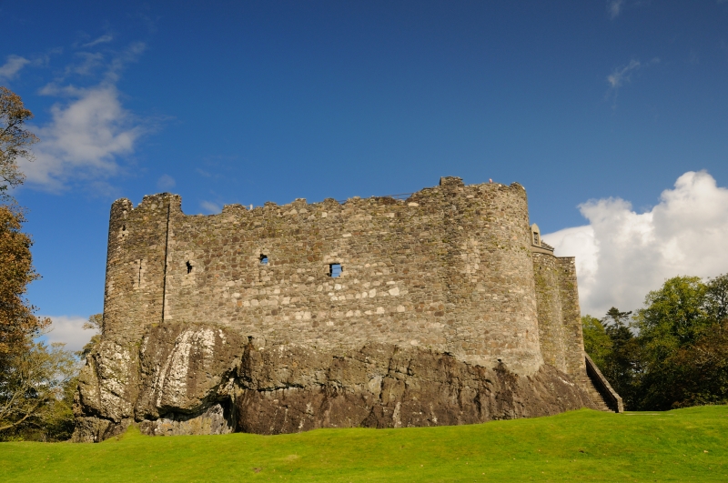
This monument is a castle, whose visible remains date back to the 13th Century, and the remains of associated structures. It is already scheduled and in state care, but this rescheduling is necessary to ensure that the most important area of archaeological and historical remains is adequately protected in the light of imperfections in earlier scheduling documentation.
The castle is built on a rock some 6m to 9m in height. The curtain walls follow the shape of the rock giving an irregular quadrilateral plan. At each corner are slightly expressed round corner towers. The east or gate tower was remodelled in the late 15th and 16th Centuries to produce what is effectively a tower house over the entrance.
The north and west towers also contained accommodation but the only surviving range within the courtyard dates from the late 16th Century. Beyond the walls of the castle stand the remains of the 18th-century stables and a cottage which now houses a shop and works accommodation.
The history of Dunstaffnage rises out of tradition. It is said that the Stone of Destiny was kept at Dunstaffnage until Kenneth MacAlpin had it moved to Scone. The castle as it stands today, though, was founded by the MacDougalls in the second quarter of the 13th Century. Following the Battle of the Pass of Brander, Robert the Bruce besieged and took the castle.
The MacDougall lands were forfeited and passed, largely, to the Campbells. David II returned part of the Lordship of Lorn to the MacDougalls before it passed through marriage to John Stewart of Innermeath in 1388. Little is heard of the castle until the Lordship passed to the Earl of Argyll in 1469. The Earls entrusted custody of the castle to a Captain, a post which has become hereditary.
During the 16th and 17th Centuries the castle was used by the Crown and the Earls of Argyll as a base for campaigns in the Western Isles. It was garrisoned in the Civil Wars, throughout the Commonwealth occupation, and was burnt by the Marquess of Atholl following the Marquess of Argyll's rising in 1685. It was again garrisoned by government troops during both major Jacobite risings and remained a residence for the Captains until the gate house was gutted by fire in 1810. The gate house was restored by the Duke of Argyll in 1903-4.
The area to be scheduled includes all the features described above and an area around them which is likely to retain archaeological evidence relating to their construction and use. It is defined to the east by the stone boundary wall, to the NW by a line 20m out from the NW wall of the castle and to the SW by a line 50m out from the SW wall of the castle. The area measures approximately 140m SW-NE at its greatest extent by 140m and is marked in red on the accompanying map extract.
Source: Historic Environment Scotland
The monument is of national importance because it is a well preserved 13th-century castle. It has a long history as an outpost of Royal authority in Argyll, either as a Royal castle or through the Earls of Argyll. It has seen continuous and varied use up until the start of the nineteenth century. Its archaeology has the potential to add greatly to our knowledge of a long period of the history of Argyll. Its importance is reflected in its status as a property in state care.
Source: Historic Environment Scotland
Bibliography
RCAHMS records the monument as NM 83 SE 2.
Historic Environment Scotland Properties
Dunstaffnage Castle & Chapel
https://www.historicenvironment.scot/visit-a-place/places/dunstaffnage-castle-and-chapel
Find out more
Related Designations
Dunstaffnage Castle ChapelSM90121
Designation TypeScheduled MonumentStatusDesignated
Source: Historic Environment Scotland
Other nearby scheduled monuments